
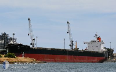
TWINKLE ISLAND
Bulk Carrier
Current Trip
| Time Travelled | 5 days |
|---|---|
| Remaining Time | --- |
| Distance Travelled | 1395.04 nm |
| Remaining Distance | --- |
| AVG Speed | 10.4 Knots |
| MAX Speed | 14.8 Knots |
| AVG Wind | 4.1 knots |
| MAX Wind | 10 knots |
| MIN Temp | 26°C / 78.8°F |
| MAX Temp | 30.5°C / 86.9°F |
| Draught | 7.6 m |
| Position Received | 2 d ago |
Current Position
| Longitude | 103.47649° |
|---|---|
| Latitude | 1.22021° |
| Status | Under way using engine |
| Speed | 13 Knots |
| Course | 277.5° |
| Area | Singapore Strait |
| Station | T-AIS |
| Position Received | 2 d ago |
Info
Information
The current position of TWINKLE ISLAND is in Singapore Strait with coordinates 1.22021° / 103.47649° as reported on 2024-05-07 20:41 by AIS to our vessel tracker app. The vessel's current speed is 13 Knots and is heading at the port of TERNEUZEN. The estimated time of arrival as calculated by MyShipTracking vessel tracking app is 2024-05-07 05:30 LT
The vessel TWINKLE ISLAND (IMO: 9512367, MMSI: 538004652) is a Bulk Carrier that was built in 2012 ( 12 years old ). It's sailing under the flag of [MH] Marshall Is.
In this page you can find informations about the vessels current position, last detected port calls, and current voyage information. If the vessels is not in coverage by AIS you will find the latest position.
The current position of TWINKLE ISLAND is detected by our AIS receivers and we are not responsible for the reliability of the data. The last position was recorded while the vessel was in Coverage by the Ais receivers of our vessel tracking app.
The current draught of TWINKLE ISLAND as reported by AIS is 7.6 meters
Weather
| Temperature | 29°C / 84.2°F |
|---|---|
| Wind Speed | 4 knots |
| Direction | 104° ESE |
| Pressure | 1009.6 hPa |
| Humidity | 76.8 % |
| Cloud Coverage | 98 % |
Featured Company
Last Port Calls
| Port | Arrival | Departure | Time In Port |
|---|---|---|---|
| 2024-04-30 10:01 | 2024-05-04 23:32 | 4 d | |
| 2024-03-19 15:53 |
Last Trips
| Origin | Departure | Destination | Arrival | Distance | |
|---|---|---|---|---|---|
| 2024-03-19 12:53 | 2024-04-30 17:01 | 10347.02 nm |
Events
| Time | Event | Details | Position / Dest | Info |
|---|---|---|---|---|
| 2024-05-07 20:48 | Status Changed | Default Under way using engine |
1.22395 / 103.45043
FOR ORDER
|
Speed: 13 kn Course: 277.5° |
| 2024-05-07 20:41 | OUT of Coverage |
1.22021 / 103.47649
Singapore Strait
|
Speed: 13 kn Course: 277.5° |
|
| 2024-05-07 20:08 | Change Sea Area | Malaysian part of the Singapore Strait Indonesian part of the Singapore Strait |
1.19776 / 103.59110
Singapore Strait
|
Speed: 12.3 kn Course: 281.5° |
| 2024-05-07 19:23 | Change Sea Area | Indonesian part of the Singapore Strait Singaporean part of the Singapore Strait |
1.13980 / 103.72158
Singapore Strait
|
Speed: 10.7 kn Course: 283.1° |
| 2024-05-07 17:13 | START Moving | 2.43 nm, North East of SINGAPORE |
1.27428 / 103.89144
FOR ORDER
|
Speed: 4.9 kn Course: 122° |
| 2024-05-07 17:07 | Status Changed | Under way using engine At anchor |
1.27719 / 103.89066
FOR ORDER
|
Speed: 0.3 kn Course: 219° |
| 2024-05-07 12:41 | Draught Changed | 7.6 7.1 |
1.27633 / 103.88797
FOR ORDER
|
Speed: Course: 58° |
| 2024-05-07 11:04 | Destination Changed | FOR ORDER SGSIN |
1.27657 / 103.88783
FOR ORDER
|
Speed: Course: 68° |
| 2024-05-07 06:46 | Status Changed | At anchor Under way using engine |
1.27821 / 103.89123
SGSIN
|
Speed: 0.4 kn Course: 235° |
| 2024-05-07 06:25 | STOP Moving | 2.44 nm, North East of SINGAPORE |
1.27602 / 103.89073
SGSIN
|
Speed: 0.3 kn Course: 186° |