
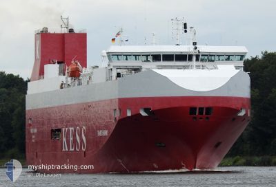
THAMES HIGHWAY
Vehicles Carrier
Current Trip
| Time Travelled | 1 day |
|---|---|
| Remaining Time | --- |
| Distance Travelled | 446.74 nm |
| Remaining Distance | 110.76 nm |
| AVG Speed | 13.2 Knots |
| MAX Speed | 19.7 Knots |
| AVG Wind | 14.8 knots |
| MAX Wind | 34 knots |
| MIN Temp | 0.2°C / 32.36°F |
| MAX Temp | 7.1°C / 44.78°F |
| Draught | 6.8 m |
| Position Received | 1 m ago |
Current Position
| Longitude | --- |
|---|---|
| Latitude | --- |
| Status | Under way using engine |
| Speed | 10.9 Knots |
| Course | 101.8° |
| Area | North Sea |
| Station | T-AIS |
| Position Received | 1 m ago |
Info
Information
The current position of THAMES HIGHWAY is in North Sea with coordinates 53.41590° / 4.66378° as reported on 2026-01-08 10:39 by AIS to our vessel tracker app. The vessel's current speed is 10.9 Knots and is heading at the port of EMDEN. The estimated time of arrival as calculated by MyShipTracking vessel tracking app is 2026-01-08 19:00 LT
The vessel THAMES HIGHWAY (IMO: 9316294, MMSI: 311996000) is a Vehicles Carrier that was built in 2005 ( 21 years old ). It's sailing under the flag of [BS] Bahamas.
In this page you can find informations about the vessels current position, last detected port calls, and current voyage information. If the vessels is not in coverage by AIS you will find the latest position.
The current position of THAMES HIGHWAY is detected by our AIS receivers and we are not responsible for the reliability of the data. The last position was recorded while the vessel was in Coverage by the Ais receivers of our vessel tracking app.
The current draught of THAMES HIGHWAY as reported by AIS is 6.8 meters
Weather
| Temperature | 6.4°C / 43.52°F |
|---|---|
| Wind Speed | 2 knots |
| Direction | 113° ESE |
| Pressure | 1002.8 hPa |
| Humidity | 72.8 % |
| Cloud Coverage | 87 % |
Featured Company
Last Port Calls
| Port | Arrival | Departure | Time In Port |
|---|---|---|---|
| 2026-01-06 02:27 | 2026-01-06 14:22 | 11 h | |
| 2026-01-03 16:01 | 2026-01-03 23:48 | 7 h | |
| 2025-12-30 07:28 | 2025-12-31 16:45 | 1 d | |
| 2025-12-26 12:38 | 2025-12-28 15:49 | 2 d | |
| 2025-12-22 03:29 | 2025-12-23 22:17 | 1 d | |
| 2025-12-18 12:59 | 2025-12-19 22:39 | 1 d | |
| 2025-12-15 07:24 | 2025-12-16 15:22 | 1 d | |
| 2025-12-08 06:24 | 2025-12-09 03:34 | 21 h | |
| 2025-12-05 01:20 | 2025-12-05 20:20 | 19 h | |
| 2025-12-03 05:53 | 2025-12-03 17:13 | 11 h |
Last Trips
| Origin | Departure | Destination | Arrival | Distance | |
|---|---|---|---|---|---|
| 2026-01-03 23:48 | 2026-01-06 02:27 | 550.12 nm | |||
| 2025-12-31 16:45 | 2026-01-03 16:01 | 859.72 nm | |||
| 2025-12-28 15:49 | 2025-12-30 07:28 | 581.32 nm | |||
| 2025-12-23 22:17 | 2025-12-26 12:38 | 595.10 nm | |||
| 2025-12-19 22:39 | 2025-12-22 03:29 | 596.53 nm | |||
| 2025-12-16 15:22 | 2025-12-18 12:59 | 606.28 nm | |||
| 2025-12-09 03:34 | 2025-12-15 07:24 | 810.91 nm | |||
| 2025-12-05 20:20 | 2025-12-08 06:24 | 483.13 nm | |||
| 2025-12-03 17:13 | 2025-12-05 01:20 | 465.07 nm | |||
| 2025-12-02 16:52 | 2025-12-03 05:53 | 160.63 nm |
Events
| Time | Event | Details | Position / Dest | Info |
|---|---|---|---|---|
| 2026-01-08 10:20 | Status Changed | Under way using engine Default |
53.43127 / 4.56726
DEEME
|
Speed: 11.2 kn Course: 105° |
| 2026-01-08 10:16 | Status Changed | Default Under way using engine |
53.43419 / 4.54786
DEEME
|
Speed: 11.2 kn Course: 104.7° |
| 2026-01-08 10:10 | Change Sea Area | Dutch part of the North Sea United Kingdom part of the North Sea |
53.43888 / 4.51698
North Sea
DEEME
|
Speed: 11.2 kn Course: 105° |
| 2026-01-08 10:09 | Status Changed | Under way using engine Default |
53.43945 / 4.51366
DEEME
|
Speed: 11 kn Course: 119° |
| 2026-01-08 10:09 | IN Coverage |
53.43888 / 4.51698
North Sea
DEEME
|
Speed: 11.2 kn Course: 105° |
|
| 2026-01-07 19:57 | Status Changed | Default Under way using engine |
53.53897 / .31223
DEEME
|
Speed: 13.4 kn Course: 92.9° |
| 2026-01-07 19:52 | OUT of Coverage |
53.53972 / .28375
North Sea
DEEME
|
Speed: 13.4 kn Course: 92.9° |
|
| 2026-01-07 18:47 | START Moving | 0.47 nm, North of GRIMSBY |
53.58611 / -.06421
DEEME
|
Speed: 3.1 kn Course: 109° |
| 2026-01-07 18:47 | Draught Changed | 6.8 7.5 |
53.58631 / -.06529
DEEME
|
Speed: 2.5 kn Course: 106° |
| 2026-01-07 18:47 | Destination Changed | DEEME GBGSY |
53.58631 / -.06529
DEEME
|
Speed: 2.5 kn Course: 106° |