
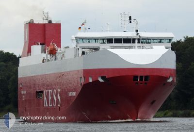
THAMES HIGHWAY
Vehicles Carrier
Current Trip
| Time Travelled | 13 h, 16 mins |
|---|---|
| Remaining Time | 6 h, 59 mins |
| Distance Travelled | 214.47 nm |
| Remaining Distance | 128.59 nm |
| AVG Speed | 15.6 Knopen |
| MAX Speed | 19 Knopen |
| AVG Wind | 14.1 knots |
| MAX Wind | 21.4 knots |
| MIN Temp | 3.2°C / 37.76°F |
| MAX Temp | 7.8°C / 46.04°F |
| Diepgang | 7.6 M |
| Positie ontvangen | 1 m geleden |
Current Position
| Lengtegraad | 1.76886° |
|---|---|
| Breedtegraat | 54.23108° |
| Status | Under way using engine |
| Snelheid | 17.2 Knopen |
| Koers | 285.1° |
| Gebied | North Sea |
| Station | T-AIS |
| Positie ontvangen | 1 m geleden |
Info
Information
The current position of THAMES HIGHWAY is in North Sea with coordinates 54.23108° / 1.76886° as reported on 2024-04-25 09:34 by AIS to our vessel tracker app. The vessel's current speed is 17.2 Knopen and is heading at the port of TYNE. The estimated time of arrival as calculated by MyShipTracking vessel tracking app is 2024-04-25 16:34 LT
The vessel THAMES HIGHWAY (IMO: 9316294, MMSI: 311996000) is a Vehicles Carrier that was built in 2005 ( 19 Jaar oud ). It's sailing under the flag of [BS] Bahamas.
In this page you can find informations about the vessels current position, last detected port calls, and current voyage information. If the vessels is not in coverage by AIS you will find the latest position.
The current position of THAMES HIGHWAY is detected by our AIS receivers and we are not responsible for the reliability of the data. The last position was recorded while the vessel was in Coverage by the Ais receivers of our vessel tracking app.
The current draught of THAMES HIGHWAY as reported by AIS is 7.6 meters
Weather
| Temperature | 5.4°C / 41.72°F |
|---|---|
| Wind Speed | 14 knots |
| Direction | 321° NW |
| Pressure | 1000.6 hPa |
| Humidity | 79.8 % |
| Cloud Coverage | 100 % |
Featured Company
Last Port Calls
| Port | Arrival | Departure | Time In Port |
|---|---|---|---|
| 2024-04-24 09:22 | 2024-04-24 20:19 | 10 h | |
| 2024-04-18 19:38 | 2024-04-19 13:24 | 17 h | |
| 2024-04-15 22:59 | 2024-04-16 12:52 | 13 h | |
| 2024-04-14 10:28 | 2024-04-15 05:21 | 18 h | |
| 2024-04-13 02:19 | 2024-04-13 15:21 | 13 h | |
| 2024-04-11 16:27 | 2024-04-12 06:46 | 14 h | |
| 2024-04-10 09:20 | 2024-04-10 20:10 | 10 h | |
| 2024-04-05 02:16 | 2024-04-07 22:46 | 2 d | |
| 2024-04-03 03:54 | 2024-04-03 16:25 | 12 h | |
| 2024-04-01 22:34 | 2024-04-02 17:23 | 18 h |
Last Trips
| Origin | Departure | Destination | Arrival | Distance | |
|---|---|---|---|---|---|
| 2024-04-19 15:24 | 2024-04-24 11:22 | 561.96 nm | |||
| 2024-04-16 14:52 | 2024-04-18 21:38 | 549.17 nm | |||
| 2024-04-15 06:21 | 2024-04-16 00:59 | 275.56 nm | |||
| 2024-04-13 17:21 | 2024-04-14 11:28 | 281.02 nm | |||
| 2024-04-12 07:46 | 2024-04-13 04:19 | 333.78 nm | |||
| 2024-04-10 22:10 | 2024-04-11 17:27 | 337.20 nm | |||
| 2024-04-08 00:46 | 2024-04-10 11:20 | 550.80 nm | |||
| 2024-04-03 18:25 | 2024-04-05 04:16 | 460.96 nm | |||
| 2024-04-02 19:23 | 2024-04-03 05:54 | 160.42 nm | |||
| 2024-03-31 16:13 | 2024-04-02 00:34 | 397.56 nm |
Events
| Tijd | Evenement | Details | Positie / Bestemming | Info |
|---|---|---|---|---|
| 2024-04-25 09:26 | Status Changed | Under way using engine Default |
54.22047 / 1.83573
GBNCL
|
Snelheid: 17.2 kn Koers: 285° |
| 2024-04-25 09:19 | Status Changed | Default Under way using engine |
54.21226 / 1.88775
GBNCL
|
Snelheid: 17 kn Koers: 284.4° |
| 2024-04-25 09:04 | Status Changed | Under way using engine Default |
54.19393 / 2.00357
GBNCL
|
Snelheid: 17 kn Koers: 286° |
| 2024-04-25 08:41 | Status Changed | Default Under way using engine |
54.16679 / 2.17772
GBNCL
|
Snelheid: 16.6 kn Koers: 284.3° |
| 2024-04-25 08:18 | Gevonden in zee | United Kingdom part of the North Sea |
54.13973 / 2.35400
North Sea
GBNCL
|
Snelheid: 16.7 kn Koers: 285.6° |
| 2024-04-25 08:18 | Status Changed | Under way using engine Default |
54.13973 / 2.35400
GBNCL
|
Snelheid: 17 kn Koers: 286° |
| 2024-04-25 08:00 | Binnenbereik |
54.13973 / 2.35400
North Sea
GBNCL
|
Snelheid: 16.7 kn Koers: 285.6° |
|
| 2024-04-25 01:20 | Status Changed | Default Under way using engine |
53.83833 / 5.63333
GBNCL
|
Snelheid: 18.1 kn Koers: 302.2° |
| 2024-04-25 01:13 | Buitenbereik |
53.82032 / 5.68108
North Sea
GBNCL
|
Snelheid: 18.1 kn Koers: 302.2° |
|
| 2024-04-24 23:28 | Wijzig zee gebeid | Dutch part of the North Sea German part of the North Sea |
53.61918 / 6.29437
North Sea
GBNCL
|
Snelheid: 15 kn Koers: 274.5° |