
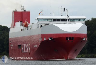
THAMES HIGHWAY
Vehicles Carrier
Current Trip
| Time Travelled | 4 days |
|---|---|
| Remaining Time | 1 h, 38 mins |
| Distance Travelled | 531.62 nm |
| Remaining Distance | 34.92 nm |
| AVG Speed | 12.6 Knop |
| MAX Speed | 18.4 Knop |
| AVG Wind | 20 knots |
| MAX Wind | 31.6 knots |
| MIN Temp | 5.1°C / 41.18°F |
| MAX Temp | 9.4°C / 48.92°F |
| Djupgående | 6.8 m |
| Position mottagen | 1 h, 11 m sen |
Current Position
| Longitud | 6.03131° |
|---|---|
| Latitude | 53.59807° |
| Status | Under way using engine |
| Fart | 17 Knop |
| Kurs | 80° |
| Område | North Sea |
| Station | T-AIS |
| Position mottagen | 1 h, 11 m sen |
Info
Information
The current position of THAMES HIGHWAY is in North Sea with coordinates 53.59807° / 6.03131° as reported on 2024-04-24 06:19 by AIS to our vessel tracker app. The vessel's current speed is 17 Knop and is heading at the port of EMDEN. The estimated time of arrival as calculated by MyShipTracking vessel tracking app is 2024-04-24 09:09 LT
The vessel THAMES HIGHWAY (IMO: 9316294, MMSI: 311996000) is a Vehicles Carrier that was built in 2005 ( 19 År gammal ). It's sailing under the flag of [BS] Bahamas.
In this page you can find informations about the vessels current position, last detected port calls, and current voyage information. If the vessels is not in coverage by AIS you will find the latest position.
The current position of THAMES HIGHWAY is detected by our AIS receivers and we are not responsible for the reliability of the data. The last position was recorded while the vessel was in Coverage by the Ais receivers of our vessel tracking app.
The current draught of THAMES HIGHWAY as reported by AIS is 6.8 meters
Weather
| Temperature | 6.8°C / 44.24°F |
|---|---|
| Wind Speed | 27 knots |
| Direction | 340° NNW |
| Pressure | 1005.8 hPa |
| Humidity | 83.5 % |
| Cloud Coverage | 100 % |
Featured Company
Last Port Calls
| Port | Arrival | Departure | Time In Port |
|---|---|---|---|
| 2024-04-18 19:38 | 2024-04-19 13:24 | 17 h | |
| 2024-04-15 22:59 | 2024-04-16 12:52 | 13 h | |
| 2024-04-14 10:28 | 2024-04-15 05:21 | 18 h | |
| 2024-04-13 02:19 | 2024-04-13 15:21 | 13 h | |
| 2024-04-11 16:27 | 2024-04-12 06:46 | 14 h | |
| 2024-04-10 09:20 | 2024-04-10 20:10 | 10 h | |
| 2024-04-05 02:16 | 2024-04-07 22:46 | 2 d | |
| 2024-04-03 03:54 | 2024-04-03 16:25 | 12 h | |
| 2024-04-01 22:34 | 2024-04-02 17:23 | 18 h | |
| 2024-03-29 17:02 | 2024-03-31 14:13 | 1 d |
Last Trips
| Origin | Departure | Destination | Arrival | Distance | |
|---|---|---|---|---|---|
| 2024-04-16 14:52 | 2024-04-18 21:38 | 549.17 nm | |||
| 2024-04-15 06:21 | 2024-04-16 00:59 | 275.56 nm | |||
| 2024-04-13 17:21 | 2024-04-14 11:28 | 281.02 nm | |||
| 2024-04-12 07:46 | 2024-04-13 04:19 | 333.78 nm | |||
| 2024-04-10 22:10 | 2024-04-11 17:27 | 337.20 nm | |||
| 2024-04-08 00:46 | 2024-04-10 11:20 | 550.80 nm | |||
| 2024-04-03 18:25 | 2024-04-05 04:16 | 460.96 nm | |||
| 2024-04-02 19:23 | 2024-04-03 05:54 | 160.42 nm | |||
| 2024-03-31 16:13 | 2024-04-02 00:34 | 397.56 nm | |||
| 2024-03-27 20:24 | 2024-03-29 18:02 | 413.01 nm |
Events
| Tid | Event | Detaljer | Position / Dest | Information |
|---|---|---|---|---|
| 2024-04-24 06:24 | Status ändrad | Default Under way using engine |
53.60313 / 6.07423
DEEME
|
Fart: 17 kn Kurs: 80° |
| 2024-04-24 06:19 | UTANFÖR täckningsområde |
53.59807 / 6.03131
North Sea
DEEME
|
Fart: 17 kn Kurs: 80° |
|
| 2024-04-24 02:57 | Djupgående ändrat | 6.8 6.7 |
53.41222 / 4.66852
DEEME
|
Fart: 15.2 kn Kurs: 104.6° |
| 2024-04-24 02:43 | Byter havsområde | Dutch part of the North Sea United Kingdom part of the North Sea |
53.42667 / 4.57932
North Sea
DEEME
|
Fart: 15 kn Kurs: 106.9° |
| 2024-04-24 02:43 | Status ändrad | Under way using engine Default |
53.42667 / 4.57932
DEEME
|
Fart: 14.6 kn Kurs: 104° |
| 2024-04-24 02:28 | I täckningsområde |
53.42667 / 4.57932
North Sea
DEEME
|
Fart: 15 kn Kurs: 106.9° |
|
| 2024-04-23 19:42 | Status ändrad | Default Under way using engine |
53.59500 / 1.65500
DEEME
|
Fart: 16.4 kn Kurs: 79.6° |
| 2024-04-23 19:40 | UTANFÖR täckningsområde |
53.59206 / 1.63704
North Sea
DEEME
|
Fart: 16.4 kn Kurs: 79.6° |
|
| 2024-04-23 18:12 | ETA ändrat | 2024/04/24 07:00 2024/04/24 04:00 |
53.58027 / .94313
DEEME
|
Fart: 16.9 kn Kurs: 88.3° |
| 2024-04-23 17:49 | Status ändrad | Under way using engine Default |
53.56930 / .76986
DEEME
|
Fart: 15.7 kn Kurs: 80° |