
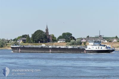
FRANCONIA
Tanker
Current Trip
| Time Travelled | 4 days |
|---|---|
| Remaining Time | --- |
| Distance Travelled | 181.94 nm |
| Remaining Distance | --- |
| AVG Speed | 5.6 Knots |
| MAX Speed | 7 Knots |
| AVG Wind | 4.9 knots |
| MAX Wind | 7 knots |
| MIN Temp | 5.2°C / 41.36°F |
| MAX Temp | 9.6°C / 49.28°F |
| Draught | 2.5 m |
| Position Received | 2 d ago |
Current Position
| Longitude | --- |
|---|---|
| Latitude | --- |
| Status | Under way using engine |
| Speed | 5.1 Knots |
| Course | 209.3° |
| Area | North Sea |
| Station | T-AIS |
| Position Received | 2 d ago |
Info
Information
The current position of FRANCONIA is in North Sea with coordinates 49.34904° / 8.48489° as reported on 2025-12-19 07:36 by AIS to our vessel tracker app. The vessel's current speed is 5.1 Knots
The vessel FRANCONIA (MMSI: 211547860) is a Tanker It's sailing under the flag of [DE] Germany.
In this page you can find informations about the vessels current position, last detected port calls, and current voyage information. If the vessels is not in coverage by AIS you will find the latest position.
The current position of FRANCONIA is detected by our AIS receivers and we are not responsible for the reliability of the data. The last position was recorded while the vessel was in Coverage by the Ais receivers of our vessel tracking app.
The current draught of FRANCONIA as reported by AIS is 2.5 meters
Weather
| Temperature | 5.2°C / 41.36°F |
|---|---|
| Wind Speed | 3 knots |
| Direction | 164° SSE |
| Pressure | 1020.8 hPa |
| Humidity | 76.5 % |
| Cloud Coverage | 98 % |
Featured Company
Last Port Calls
| Port | Arrival | Departure | Time In Port |
|---|---|---|---|
| 2025-12-17 07:00 | 2025-12-17 10:24 | 3 h | |
| 2025-12-16 13:56 | 2025-12-16 14:54 | 57 m | |
| 2025-12-15 17:01 | 2025-12-16 12:16 | 19 h | |
| 2025-12-15 13:16 | 2025-12-15 16:18 | 3 h | |
| 2025-12-09 11:14 | 2025-12-09 14:35 | 3 h | |
| 2025-12-08 15:52 | 2025-12-08 17:24 | 1 h | |
| 2025-12-07 12:08 | 2025-12-08 05:41 | 17 h | |
| 2025-12-05 20:25 | 2025-12-07 11:20 | 1 d | |
| 2025-12-05 12:37 | 2025-12-05 13:01 | 23 m | |
| 2025-12-03 14:28 | 2025-12-05 09:26 | 1 d |
Most Visited Ports (Last year)
| Port | Arrivals | |
|---|---|---|
| 31 | ||
| 25 | ||
| 23 | ||
| 19 | ||
| 15 | ||
| 14 |
Last Trips
| Origin | Departure | Destination | Arrival | Distance | |
|---|---|---|---|---|---|
| 2025-12-16 14:54 | 2025-12-17 07:00 | 100.68 nm | |||
| 2025-12-16 12:16 | 2025-12-16 13:56 | 15.47 nm | |||
| 2025-12-15 16:18 | 2025-12-15 17:01 | 6.80 nm | |||
| 2025-12-09 14:35 | 2025-12-15 13:16 | 443.40 nm | |||
| 2025-12-08 17:24 | 2025-12-09 11:14 | 83.00 nm | |||
| 2025-12-08 05:41 | 2025-12-08 15:52 | 73.28 nm | |||
| 2025-12-07 11:20 | 2025-12-07 12:08 | 6.97 nm | |||
| 2025-12-05 13:01 | 2025-12-05 20:25 | 55.54 nm | |||
| 2025-12-05 09:26 | 2025-12-05 12:37 | 21.60 nm | |||
| 2025-12-03 11:01 | 2025-12-03 14:28 | 21.26 nm |
Events
| Time | Event | Details | Position / Dest | Info |
|---|---|---|---|---|
| 2025-12-19 07:39 | Status Changed | Default Under way using engine |
49.34518 / 8.48005
KARLSRUHE
|
Speed: 5.1 kn Course: 209.3° |
| 2025-12-19 07:36 | OUT of Coverage |
49.34904 / 8.48489
North Sea
|
Speed: 5.1 kn Course: 209.3° |
|
| 2025-12-19 06:40 | Status Changed | Under way using engine Default |
49.42599 / 8.50587
KARLSRUHE
|
Speed: 5.6 kn Course: 183° |
| 2025-12-19 06:36 | Status Changed | Default Under way using engine |
49.43244 / 8.50940
KARLSRUHE
|
Speed: 5.6 kn Course: 180° |
| 2025-12-19 06:12 | Status Changed | Under way using engine Default |
49.44261 / 8.46494
KARLSRUHE
|
Speed: 5.5 kn Course: 96° |
| 2025-12-19 06:09 | Status Changed | Default Under way using engine |
49.44289 / 8.45871
KARLSRUHE
|
Speed: 5.4 kn Course: 113.1° |
| 2025-12-19 06:00 | IN Coverage |
49.44881 / 8.44318
North Sea
|
Speed: 5.5 kn Course: 146° |
|
| 2025-12-18 19:38 | OUT of Coverage |
49.58570 / 8.42156
North Sea
KARLSRUHE
|
Speed: 5.7 kn Course: 150.5° |
|
| 2025-12-18 11:08 | IN Coverage |
49.98141 / 7.86590
North Sea
KARLSRUHE
|
Speed: 4 kn Course: 151.7° |
|
| 2025-12-18 00:47 | OUT of Coverage |
50.51884 / 7.29708
North Sea
KARLSRUHE
|
Speed: 4.7 kn Course: 162.7° |