
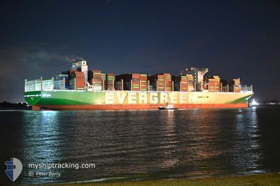
EVER ACT
Cargo D
Current Trip
| Time Travelled | 13 h, 13 mins |
|---|---|
| Remaining Time | --- |
| Distance Travelled | 108.28 nm |
| Remaining Distance | 28.34 nm |
| AVG Speed | 6.8 Knots |
| MAX Speed | 12.7 Knots |
| AVG Wind | 17.2 knots |
| MAX Wind | 19.8 knots |
| MIN Temp | 5.6°C / 42.08°F |
| MAX Temp | 8.1°C / 46.58°F |
| Draught | 12.6 m |
| Position Received | 1 m ago |
Current Position
| Longitude | --- |
|---|---|
| Latitude | --- |
| Status | Under way using engine |
| Speed | 1.4 Knots |
| Course | 185° |
| Area | North Sea |
| Station | T-AIS |
| Position Received | 1 m ago |
Info
Information
The current position of EVER ACT is in North Sea with coordinates 52.16172° / 1.89135° as reported on 2024-12-14 22:42 by AIS to our vessel tracker app. The vessel's current speed is 1.4 Knots and is heading at the port of FELIXSTOWE. The estimated time of arrival as calculated by MyShipTracking vessel tracking app is 2024-12-16 03:00 LT
The vessel EVER ACT (IMO: 9893905, MMSI: 352978199) is a Cargo D It's sailing under the flag of [PA] Panama.
In this page you can find informations about the vessels current position, last detected port calls, and current voyage information. If the vessels is not in coverage by AIS you will find the latest position.
The current position of EVER ACT is detected by our AIS receivers and we are not responsible for the reliability of the data. The last position was recorded while the vessel was in Coverage by the Ais receivers of our vessel tracking app.
The current draught of EVER ACT as reported by AIS is 12.6 meters
Weather
| Temperature | 6.6°C / 43.88°F |
|---|---|
| Wind Speed | 17 knots |
| Direction | 278° W |
| Pressure | 1022.7 hPa |
| Humidity | 85.9 % |
| Cloud Coverage | 100 % |
Featured Company
Last Port Calls
| Port | Arrival | Departure | Time In Port |
|---|---|---|---|
| 2024-12-11 08:59 | 2024-12-14 09:31 | 3 d | |
| 2024-11-13 12:06 | 2024-11-14 05:47 | 17 h | |
| 2024-11-08 14:52 | 2024-11-09 21:32 | 1 d | |
| 2024-11-06 08:12 | 2024-11-07 05:05 | 20 h | |
| 2024-11-02 05:00 | 2024-11-03 05:16 | 1 d | |
| 2024-10-31 13:28 | 2024-11-01 04:16 | 14 h | |
| 2024-10-28 19:38 | 2024-10-30 02:56 | 1 d | |
| 2024-10-24 11:47 | 2024-10-26 03:45 | 1 d | |
| 2024-10-19 08:45 | 2024-10-20 10:36 | 1 d | |
| 2024-10-13 12:17 | 2024-10-15 00:01 | 1 d |
Last Trips
| Origin | Departure | Destination | Arrival | Distance | |
|---|---|---|---|---|---|
| 2024-11-14 13:47 | 2024-12-11 09:59 | 11858.15 nm | |||
| 2024-11-10 05:32 | 2024-11-13 20:06 | 1537.01 nm | |||
| 2024-11-07 13:05 | 2024-11-08 22:52 | 450.83 nm | |||
| 2024-11-03 13:16 | 2024-11-06 16:12 | 528.01 nm | |||
| 2024-11-01 12:16 | 2024-11-02 13:00 | 171.53 nm | |||
| 2024-10-30 10:56 | 2024-10-31 21:28 | 446.00 nm | |||
| 2024-10-26 11:45 | 2024-10-29 03:38 | 935.01 nm | |||
| 2024-10-20 18:36 | 2024-10-24 19:47 | 1745.39 nm | |||
| 2024-10-15 05:31 | 2024-10-19 16:45 | 1576.57 nm | |||
| 2024-09-15 20:01 | 2024-10-13 17:47 | 10616.33 nm |
Events
| Time | Event | Details | Position / Dest | Info |
|---|---|---|---|---|
| 2024-12-14 17:21 | ETA Changed | 2024/12/16 03:00 2024/12/14 18:00 |
52.12472 / 1.88578
NLRTM>GBFXT
|
Speed: 3.6 kn Course: 240° |
| 2024-12-14 14:47 | Change Sea Area | United Kingdom part of the North Sea Dutch part of the North Sea |
52.05850 / 2.66776
North Sea
NLRTM>GBFXT
|
Speed: 12.3 kn Course: 296.5° |
| 2024-12-14 09:45 | START Moving | 0.62 nm, South East of MAASVLAKTE - ROTTERDAM |
51.95670 / 4.08368
NLRTM>GBFXT
|
Speed: 3.1 kn Course: 12° |
| 2024-12-14 09:31 | PORT DEPARTURE |
|
51.95044 / 4.08032
NLRTM>GBFXT
|
Speed: 2 kn Course: 285° |
| 2024-12-14 08:59 | ETA Changed | 2024/12/14 18:00 2024/12/14 17:00 |
51.94662 / 4.04792
[NL] MAASVLAKTE - ROTTERDAM
|
Speed: 0.6 kn Course: 261° |
| 2024-12-14 08:55 | Draught Changed | 12.6 16.3 |
51.94688 / 4.04711
[NL] MAASVLAKTE - ROTTERDAM
|
Speed: 0.4 kn Course: 261° |
| 2024-12-14 08:55 | ETA Changed | 2024/12/14 17:00 2024/12/11 07:00 |
51.94688 / 4.04711
[NL] MAASVLAKTE - ROTTERDAM
|
Speed: 0.4 kn Course: 261° |
| 2024-12-14 08:55 | Status Changed | Under way using engine Moored |
51.94691 / 4.04702
[NL] MAASVLAKTE - ROTTERDAM
|
Speed: Course: 260° |
| 2024-12-14 08:06 | Status Changed | Moored Default |
51.94700 / 4.04684
[NL] MAASVLAKTE - ROTTERDAM
|
Speed: Course: 258° |
| 2024-12-14 08:03 | Status Changed | Default Moored |
51.94701 / 4.04684
[NL] MAASVLAKTE - ROTTERDAM
|
Speed: Course: 258° |