
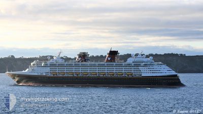
DISNEY MAGIC
Passengers Ship
Current Trip
MXCZM>KYGEC
| Time Travelled | 1 day |
|---|---|
| Remaining Time | --- |
| Distance Travelled | 452.05 nm |
| Remaining Distance | --- |
| AVG Speed | 18.9 Knots |
| MAX Speed | 20.5 Knots |
| AVG Wind | 12.7 knots |
| MAX Wind | 18.8 knots |
| MIN Temp | 26.1°C / 78.98°F |
| MAX Temp | 27.3°C / 81.14°F |
| Draught | 8.3 m |
| Position Received | 2 d ago |
Current Position
| Longitude | -86.78336° |
|---|---|
| Latitude | 20.77732° |
| Status | Under way using engine |
| Speed | 22.1 Knots |
| Course | 39.4° |
| Area | Caribbean Sea |
| Station | T-AIS |
| Position Received | 2 d ago |
Info
Information
The current position of DISNEY MAGIC is in Caribbean Sea with coordinates 20.77732° / -86.78336° as reported on 2024-04-16 22:32 by AIS to our vessel tracker app. The vessel's current speed is 22.1 Knots
The vessel DISNEY MAGIC (IMO: 9126807, MMSI: 308516000) is a Passengers Ship that was built in 1998 ( 26 years old ). It's sailing under the flag of [BS] Bahamas.
In this page you can find informations about the vessels current position, last detected port calls, and current voyage information. If the vessels is not in coverage by AIS you will find the latest position.
The current position of DISNEY MAGIC is detected by our AIS receivers and we are not responsible for the reliability of the data. The last position was recorded while the vessel was in Coverage by the Ais receivers of our vessel tracking app.
The current draught of DISNEY MAGIC as reported by AIS is 8.3 meters
Weather
| Temperature | 27°C / 80.6°F |
|---|---|
| Wind Speed | 12 knots |
| Direction | 85° E |
| Pressure | 1012.3 hPa |
| Humidity | 72.1 % |
| Cloud Coverage | 25 % |
Featured Company
Last Port Calls
| Port | Arrival | Departure | Time In Port |
|---|---|---|---|
| 2024-04-18 12:35 | 2024-04-18 21:26 | 8 h | |
| 2024-04-16 13:38 | 2024-04-16 21:22 | 7 h | |
| 2024-04-14 12:08 | 2024-04-14 21:54 | 9 h | |
| 2024-04-12 15:47 | 2024-04-13 01:42 | 9 h | |
| 2024-04-11 15:02 | 2024-04-11 23:05 | 8 h | |
| 2024-04-09 10:44 | 2024-04-09 21:44 | 11 h | |
| 2024-04-07 14:01 | 2024-04-07 20:50 | 6 h | |
| 2024-04-06 13:10 | 2024-04-06 22:20 | 9 h | |
| 2024-04-04 10:40 | 2024-04-04 21:47 | 11 h | |
| 2024-03-31 11:53 | 2024-03-31 21:43 | 9 h |
Last Trips
| Origin | Departure | Destination | Arrival | Distance | |
|---|---|---|---|---|---|
| 2024-04-16 16:22 | 2024-04-18 07:35 | 571.54 nm | |||
| 2024-04-14 16:54 | 2024-04-16 08:38 | 724.46 nm | |||
| 2024-04-12 20:42 | 2024-04-14 07:08 | 577.72 nm | |||
| 2024-04-11 18:05 | 2024-04-12 10:47 | 284.65 nm | |||
| 2024-04-09 16:44 | 2024-04-11 10:02 | 724.39 nm | |||
| 2024-04-07 15:50 | 2024-04-09 05:44 | 732.29 nm | |||
| 2024-04-06 16:20 | 2024-04-07 09:01 | 268.58 nm | |||
| 2024-04-04 16:47 | 2024-04-06 07:10 | 572.78 nm | |||
| 2024-03-31 16:43 | 2024-04-04 05:40 | 1133.67 nm | |||
| 2024-03-29 15:38 | 2024-03-31 06:53 | 729.82 nm |
Events
| Time | Event | Details | Position / Dest | Info |
|---|---|---|---|---|
| 2024-04-18 21:26 | PORT DEPARTURE |
|
18.56173 / -77.25819
MXCZM>KYGEC
|
Speed: 0.6 kn Course: 31° |
| 2024-04-18 12:35 | STOP Moving |
18.49446 / -77.64716
[JM] FALMOUTH
|
Speed: 0.1 kn Course: 33° |
|
| 2024-04-18 12:35 | PORT ARRIVAL |
|
18.49446 / -77.64716
[JM] FALMOUTH
|
Speed: 1.3 kn Course: 36° |
| 2024-04-17 22:59 | START Moving |
19.30018 / -81.39940
MXCZM>KYGEC
|
Speed: 8.8 kn Course: 270° |
|
| 2024-04-17 15:31 | STOP Moving |
19.29949 / -81.38856
MXCZM>KYGEC
|
Speed: 0.3 kn Course: 72° |
|
| 2024-04-16 22:48 | Status Changed | Default Under way using engine |
20.85021 / -86.71780
MXCZM>KYGEC
|
Speed: 22.1 kn Course: 39.4° |
| 2024-04-16 22:32 | OUT of Coverage |
20.77732 / -86.78336
Caribbean Sea
MXCZM>KYGEC
|
Speed: 22.1 kn Course: 39.4° |
|
| 2024-04-16 21:23 | START Moving | 0.52 nm, North of COZUMEL |
20.51082 / -86.96192
MXCZM>KYGEC
|
Speed: 3.1 kn Course: 267° |
| 2024-04-16 21:22 | PORT DEPARTURE |
|
20.51049 / -86.96086
MXCZM>KYGEC
|
Speed: 2.5 kn Course: 258° |
| 2024-04-16 21:14 | Status Changed | Under way using engine Moored |
20.50973 / -86.95726
[MX] COZUMEL
|
Speed: Course: 200° |