
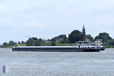
CURA DEI
Cargo
Current Trip
| Trip Time | 4 h, 14 mins |
|---|---|
| Trip Distance | 30.87 nm |
| AVG Speed | 8 Knots |
| MAX Speed | 11.3 Knots |
| Draught | 0.1 m |
| AVG Wind | 15.4 knots |
| MAX Wind | 17 knots |
| MIN Temp | 2°C / 35.6°F |
| MAX Temp | 3.6°C / 38.48°F |
| Position Received | 1 d ago |
Current Position
| Longitude | --- |
|---|---|
| Latitude | --- |
| Status | Under way using engine |
| Speed | |
| Course | --- |
| Area | North Sea |
| Station | T-AIS |
| Position Received | 1 d ago |
Info
Information
The current position of CURA DEI is in North Sea with coordinates 51.50689° / 4.25503° as reported on 2026-01-09 15:07 by AIS to our vessel tracker app. The vessel's current speed is 0 Knots and is currently inside the port of BERGEN OP ZOOM.
The vessel CURA DEI (MMSI: 244670386) is a Cargo It's sailing under the flag of [NL] Netherlands.
In this page you can find informations about the vessels current position, last detected port calls, and current voyage information. If the vessels is not in coverage by AIS you will find the latest position.
The current position of CURA DEI is detected by our AIS receivers and we are not responsible for the reliability of the data. The last position was recorded while the vessel was in Coverage by the Ais receivers of our vessel tracking app.
The current draught of CURA DEI as reported by AIS is 0.1 meters
Weather
| Temperature | 4.3°C / 39.74°F |
|---|---|
| Wind Speed | 13 knots |
| Direction | 330° NNW |
| Pressure | 984.5 hPa |
| Humidity | 90.8 % |
| Cloud Coverage | 100 % |
Featured Company
Last Port Calls
| Port | Arrival | Departure | Time In Port |
|---|---|---|---|
| 2026-01-09 00:00 | |||
| 2026-01-08 19:25 | 2026-01-08 19:46 | 20 m | |
| 2026-01-08 17:20 | 2026-01-08 18:12 | 52 m | |
| 2026-01-08 13:48 | 2026-01-08 16:12 | 2 h | |
| 2026-01-07 15:40 | 2026-01-07 16:46 | 1 h | |
| 2026-01-05 14:51 | 2026-01-05 15:45 | 53 m | |
| 2026-01-04 14:53 | 2026-01-05 11:04 | 20 h | |
| 2026-01-03 14:54 | 2026-01-04 10:34 | 19 h | |
| 2025-12-30 22:55 | 2025-12-31 04:59 | 6 h | |
| 2025-12-30 19:30 | 2025-12-30 19:52 | 22 m |
Last Trips
| Origin | Departure | Destination | Arrival | Distance | |
|---|---|---|---|---|---|
| 2026-01-08 19:46 | 2026-01-09 00:00 | 30.87 nm | |||
| 2026-01-08 18:12 | 2026-01-08 19:25 | 11.59 nm | |||
| 2026-01-08 16:12 | 2026-01-08 17:20 | 8.37 nm | |||
| 2026-01-07 16:46 | 2026-01-08 13:48 | 54.66 nm | |||
| 2026-01-05 15:45 | 2026-01-07 15:40 | 60.72 nm | |||
| 2026-01-05 11:04 | 2026-01-05 14:51 | 16.40 nm | |||
| 2026-01-04 10:34 | 2026-01-04 14:53 | 16.13 nm | |||
| 2025-12-31 04:59 | 2026-01-03 14:54 | 119.33 nm | |||
| 2025-12-30 19:52 | 2025-12-30 22:55 | 21.29 nm | |||
| 2025-12-30 19:52 | 2025-12-30 19:30 | 21.29 nm |
Events
| Time | Event | Details | Position / Dest | Info |
|---|---|---|---|---|
| 2026-01-09 15:07 | OUT of Coverage |
51.50689 / 4.25503
North Sea
[NL] BERGEN OP ZOOM
|
Speed: Course: 511° |
|
| 2026-01-08 23:14 | STOP Moving |
51.50602 / 4.24516
[NL] BERGEN OP ZOOM
|
Speed: 0.2 kn Course: 511° |
|
| 2026-01-08 23:00 | PORT ARRIVAL |
|
51.49675 / 4.22591
[NL] BERGEN OP ZOOM
|
Speed: 5.5 kn Course: 96.7° |
| 2026-01-08 21:18 | START Moving | 2.73 nm, East of BRUINISSE |
51.66196 / 4.16281
GERMERSHEIM
|
Speed: 4.4 kn Course: 88° |
| 2026-01-08 20:46 | STOP Moving | 2.55 nm, East of BRUINISSE |
51.66188 / 4.15784
GERMERSHEIM
|
Speed: 0.2 kn Course: 511° |
| 2026-01-08 18:46 | PORT DEPARTURE |
|
51.46866 / 4.00642
GERMERSHEIM
|
Speed: 9.3 kn Course: 351.8° |
| 2026-01-08 18:41 | START Moving |
51.45741 / 4.00908
[NL] HANSWEERT
|
Speed: 5.8 kn Course: 350° |
|
| 2026-01-08 18:25 | STOP Moving |
51.45470 / 4.00994
[NL] HANSWEERT
|
Speed: 0.2 kn Course: 511° |
|
| 2026-01-08 18:25 | PORT ARRIVAL |
|
51.45471 / 4.00994
[NL] HANSWEERT
|
Speed: 1.2 kn Course: 511° |
| 2026-01-08 17:12 | PORT DEPARTURE |
|
51.34084 / 3.81167
GERMERSHEIM
|
Speed: 10.2 kn Course: 353.3° |