
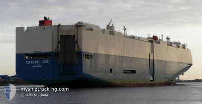
CRYSTAL ACE
Vehicles Carrier
Current Trip
| Time Travelled | 10 days |
|---|---|
| Remaining Time | --- |
| Distance Travelled | 4743.36 nm |
| Remaining Distance | --- |
| AVG Speed | 18.5 Knots |
| MAX Speed | 21 Knots |
| AVG Wind | 11.8 knots |
| MAX Wind | 25 knots |
| MIN Temp | 18.4°C / 65.12°F |
| MAX Temp | 28.1°C / 82.58°F |
| Draught | 7.8 m |
| Position Received | 4 d ago |
Current Position
| Longitude | --- |
|---|---|
| Latitude | --- |
| Status | Under way using engine |
| Speed | 19.1 Knots |
| Course | 280.7° |
| Area | North Pacific Ocean |
| Station | T-AIS |
| Position Received | 4 d ago |
Info
Information
The current position of CRYSTAL ACE is in North Pacific Ocean with coordinates 29.02957° / -140.64347° as reported on 2025-12-09 20:51 by AIS to our vessel tracker app. The vessel's current speed is 19.1 Knots and is heading at the port of KANDA. The estimated time of arrival as calculated by MyShipTracking vessel tracking app is 2025-12-20 06:00 LT
The vessel CRYSTAL ACE (IMO: 9539224, MMSI: 538004619) is a Vehicles Carrier that was built in 2012 ( 13 years old ). It's sailing under the flag of [MH] Marshall Is.
In this page you can find informations about the vessels current position, last detected port calls, and current voyage information. If the vessels is not in coverage by AIS you will find the latest position.
The current position of CRYSTAL ACE is detected by our AIS receivers and we are not responsible for the reliability of the data. The last position was recorded while the vessel was in Coverage by the Ais receivers of our vessel tracking app.
The current draught of CRYSTAL ACE as reported by AIS is 7.8 meters
Weather
| Temperature | 23.6°C / 74.48°F |
|---|---|
| Wind Speed | 16 knots |
| Direction | 331° NNW |
| Pressure | 1011.2 hPa |
| Humidity | 60.7 % |
| Cloud Coverage | 3 % |
Featured Company
Last Port Calls
| Port | Arrival | Departure | Time In Port |
|---|---|---|---|
| 2025-12-02 22:55 | 2025-12-03 08:56 | 10 h | |
| 2025-11-28 13:53 | 2025-11-29 14:56 | 1 d | |
| 2025-11-27 13:26 | 2025-11-28 00:19 | 10 h | |
| 2025-11-23 13:24 | 2025-11-24 13:19 | 23 h | |
| 2025-11-20 15:24 | 2025-11-20 19:51 | 4 h | |
| 2025-11-18 00:37 | 2025-11-18 18:57 | 18 h | |
| 2025-11-14 02:34 | 2025-11-14 21:27 | 18 h | |
| 2025-10-31 15:25 | 2025-11-05 15:57 | 5 d | |
| 2025-10-26 17:17 | 2025-10-26 22:52 | 5 h | |
| 2025-10-25 11:05 | 2025-10-26 01:13 | 14 h |
Last Trips
| Origin | Departure | Destination | Arrival | Distance | |
|---|---|---|---|---|---|
| 2025-11-29 08:56 | 2025-12-02 16:55 | 253.83 nm | |||
| 2025-11-27 18:19 | 2025-11-28 07:53 | 64.13 nm | |||
| 2025-11-24 08:19 | 2025-11-27 07:26 | 848.46 nm | |||
| 2025-11-20 14:51 | 2025-11-23 08:24 | 603.65 nm | |||
| 2025-11-18 13:57 | 2025-11-20 10:24 | 784.41 nm | |||
| 2025-11-14 18:27 | 2025-11-17 19:37 | 1173.24 nm | |||
| 2025-11-05 12:57 | 2025-11-13 23:34 | 3275.10 nm | |||
| 2025-10-26 19:52 | 2025-10-31 12:25 | 1123.56 nm | |||
| 2025-10-25 22:13 | 2025-10-26 14:17 | 178.86 nm | |||
| 2025-10-09 18:49 | 2025-10-25 08:05 | 5552.18 nm |
Events
| Time | Event | Details | Position / Dest | Info |
|---|---|---|---|---|
| 2025-12-09 20:56 | Status Changed | Default Under way using engine |
29.03430 / -140.67209
JPKND
|
Speed: 19.1 kn Course: 280.7° |
| 2025-12-09 20:51 | OUT of Coverage |
29.02957 / -140.64347
North Pacific Ocean
JPKND
|
Speed: 19.1 kn Course: 280.7° |
|
| 2025-12-09 20:23 | Status Changed | Under way using engine Default |
29.00274 / -140.47949
JPKND
|
Speed: 19.1 kn Course: 280° |
| 2025-12-09 20:23 | IN Coverage |
29.00428 / -140.48891
North Pacific Ocean
JPKND
|
Speed: 19.1 kn Course: 280.3° |
|
| 2025-12-09 18:47 | Status Changed | Default Under way using engine |
28.90605 / -139.90944
JPKND
|
Speed: 19.1 kn Course: 280.1° |
| 2025-12-09 18:47 | OUT of Coverage |
28.90576 / -139.90765
North Pacific Ocean
JPKND
|
Speed: 19.1 kn Course: 280.1° |
|
| 2025-12-09 18:39 | Status Changed | Under way using engine Default |
28.89846 / -139.86506
JPKND
|
Speed: 19 kn Course: 282° |
| 2025-12-09 18:29 | IN Coverage |
28.89846 / -139.86506
North Pacific Ocean
JPKND
|
Speed: 19.1 kn Course: 281.4° |
|
| 2025-12-09 10:30 | Status Changed | Default Under way using engine |
28.37126 / -137.00310
JPKND
|
Speed: 19 kn Course: 282.3° |
| 2025-12-09 10:26 | OUT of Coverage |
28.36704 / -136.98148
North Pacific Ocean
JPKND
|
Speed: 19 kn Course: 282.3° |