
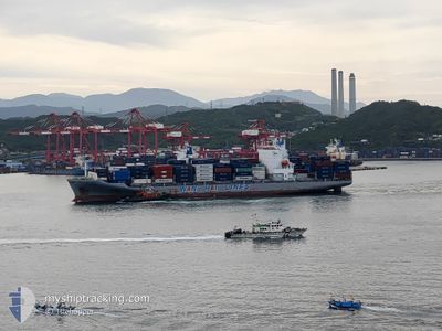
WAN HAI 325
Cargo
Current Trip
| Time Travelled | 10 h, 54 mins |
|---|---|
| Remaining Time | --- |
| Distance Travelled | 115.11 nm |
| Remaining Distance | 1538.08 nm |
| AVG Speed | 17.1 Knopen |
| MAX Speed | 17.8 Knopen |
| AVG Wind | 5.6 knots |
| MAX Wind | 10.6 knots |
| MIN Temp | 29.9°C / 85.82°F |
| MAX Temp | 30.6°C / 87.08°F |
| Diepgang | 11.4 M |
| Positie ontvangen | 7 d geleden |
Current Position
| Lengtegraad | 101.29308° |
|---|---|
| Breedtegraat | 2.81505° |
| Status | At anchor |
| Snelheid | 0.1 Knopen |
| Koers | 126° |
| Gebied | Malacca Strait |
| Station | T-AIS |
| Positie ontvangen | 7 d geleden |
Info
Information
The current position of WAN HAI 325 is in Malacca Strait with coordinates 2.81505° / 101.29308° as reported on 2024-04-21 03:36 by AIS to our vessel tracker app. The vessel's current speed is 0.1 Knopen and is heading at the port of PORT KLANG. The estimated time of arrival as calculated by MyShipTracking vessel tracking app is 2024-04-22 09:00 LT
The vessel WAN HAI 325 (IMO: 9871476, MMSI: 563119400) is a Cargo It's sailing under the flag of [SG] Singapore.
In this page you can find informations about the vessels current position, last detected port calls, and current voyage information. If the vessels is not in coverage by AIS you will find the latest position.
The current position of WAN HAI 325 is detected by our AIS receivers and we are not responsible for the reliability of the data. The last position was recorded while the vessel was in Coverage by the Ais receivers of our vessel tracking app.
The current draught of WAN HAI 325 as reported by AIS is 11.4 meters
Weather
| Temperature | 29.9°C / 85.82°F |
|---|---|
| Wind Speed | 6 knots |
| Direction | 143° SE |
| Pressure | 1009.9 hPa |
| Humidity | 74.9 % |
| Cloud Coverage | 97 % |
Featured Company
Last Port Calls
| Port | Arrival | Departure | Time In Port |
|---|---|---|---|
| 2024-04-28 00:24 | 2024-04-28 08:00 | 7 h | |
| 2024-04-21 22:00 | 2024-04-22 17:44 | 19 h | |
| 2024-04-17 11:43 | 2024-04-18 05:30 | 17 h | |
| 2024-04-12 13:54 | 2024-04-13 03:20 | 13 h | |
| 2024-04-11 12:42 | 2024-04-11 21:22 | 8 h | |
| 2024-04-10 02:17 | 2024-04-10 15:50 | 13 h | |
| 2024-04-08 08:57 | 2024-04-08 21:37 | 12 h | |
| 2024-04-02 14:04 | 2024-04-03 05:13 | 15 h | |
| 2024-03-28 11:11 | 2024-03-29 18:29 | 1 d | |
| 2024-03-26 08:45 | 2024-03-27 09:45 | 1 d |
Last Trips
| Origin | Departure | Destination | Arrival | Distance | |
|---|---|---|---|---|---|
| 2024-04-23 01:44 | 2024-04-28 05:54 | 1557.44 nm | |||
| 2024-04-18 12:30 | 2024-04-22 06:00 | 980.71 nm | |||
| 2024-04-13 11:20 | 2024-04-17 18:43 | 1492.40 nm | |||
| 2024-04-12 05:22 | 2024-04-12 21:54 | 93.22 nm | |||
| 2024-04-10 21:50 | 2024-04-11 20:42 | 294.82 nm | |||
| 2024-04-09 05:37 | 2024-04-10 08:17 | 259.82 nm | |||
| 2024-04-03 13:13 | 2024-04-08 16:57 | 1724.65 nm | |||
| 2024-03-29 23:59 | 2024-04-02 22:04 | 1408.59 nm | |||
| 2024-03-27 15:15 | 2024-03-28 16:41 | 339.46 nm | |||
| 2024-03-24 16:42 | 2024-03-26 14:15 | 774.22 nm |
Events
| Tijd | Evenement | Details | Positie / Bestemming | Info |
|---|---|---|---|---|
| 2024-04-28 08:00 | Vertrekhaven |
|
8.74231 / 78.23381
MY PKG
|
Snelheid: 7.1 kn Koers: 129° |
| 2024-04-28 07:56 | Start beweging |
8.74780 / 78.22770
[IN] TUTICORIN
|
Snelheid: 7.1 kn Koers: 129° |
|
| 2024-04-28 00:28 | Stop beweging |
8.75199 / 78.21420
[IN] TUTICORIN
|
Snelheid: 0.3 kn Koers: 114° |
|
| 2024-04-28 00:24 | Aankomsthaven |
|
8.75219 / 78.21484
[IN] TUTICORIN
|
Snelheid: 6.8 kn Koers: 311° |
| 2024-04-27 23:36 | Start beweging | 5.26 nm, South East of TUTICORIN |
8.70771 / 78.27765
MY PKG
|
Snelheid: 5.4 kn Koers: 297° |
| 2024-04-27 23:20 | Stop beweging | 5.48 nm, South East of TUTICORIN |
8.70584 / 78.28106
MY PKG
|
Snelheid: 0.3 kn Koers: 311° |
| 2024-04-27 22:30 | Start beweging | 8.26 nm, South East of TUTICORIN |
8.69220 / 78.32887
MY PKG
|
Snelheid: 3.5 kn Koers: 265° |
| 2024-04-27 06:48 | Stop beweging | 8.2 nm, South East of TUTICORIN |
8.69528 / 78.32964
MY PKG
|
Snelheid: 0.2 kn Koers: 66° |
| 2024-04-22 17:44 | Vertrekhaven |
|
2.89883 / 101.26321
MY PKG
|
Snelheid: 11.7 kn Koers: 214° |
| 2024-04-22 16:56 | Start beweging |
3.01096 / 101.35076
[MY] PORT KLANG
|
Snelheid: 5.7 kn Koers: 205° |