
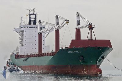
GALLOWAY
Container Ship
Current Trip
CNQDG
| Time Travelled | 1 day |
|---|---|
| Remaining Time | --- |
| Distance Travelled | 8.27 nm |
| Remaining Distance | --- |
| AVG Speed | 6.4 Knopen |
| MAX Speed | 8 Knopen |
| AVG Wind | 8.2 knots |
| MAX Wind | 14 knots |
| MIN Temp | 23.9°C / 75.02°F |
| MAX Temp | 25.8°C / 78.44°F |
| Diepgang | 9.6 M |
| Positie ontvangen | 5 h, 36 m geleden |
Current Position
| Lengtegraad | --- |
|---|---|
| Breedtegraat | --- |
| Status | Under way using engine |
| Snelheid | |
| Koers | 77° |
| Gebied | South China Sea |
| Station | T-AIS |
| Positie ontvangen | 5 h, 36 m geleden |
Info
Information
The current position of GALLOWAY is in South China Sea with coordinates 14.55860° / 120.80918° as reported on 2026-01-05 16:48 by AIS to our vessel tracker app. The vessel's current speed is 0 Knopen
The vessel GALLOWAY (IMO: 9306471, MMSI: 636019425) is a Container Ship that was built in 2005 ( 21 Jaar oud ). It's sailing under the flag of [LR] Liberia.
In this page you can find informations about the vessels current position, last detected port calls, and current voyage information. If the vessels is not in coverage by AIS you will find the latest position.
The current position of GALLOWAY is detected by our AIS receivers and we are not responsible for the reliability of the data. The last position was recorded while the vessel was in Coverage by the Ais receivers of our vessel tracking app.
The current draught of GALLOWAY as reported by AIS is 9.6 meters
Weather
| Temperature | 25.3°C / 77.54°F |
|---|---|
| Wind Speed | 13 knots |
| Direction | 3° N |
| Pressure | 1012 hPa |
| Humidity | 82.2 % |
| Cloud Coverage | 100 % |
Featured Company
Last Port Calls
| Port | Arrival | Departure | Time In Port |
|---|---|---|---|
| 2026-01-04 02:25 | 2026-01-04 18:05 | 15 h | |
| 2025-12-27 06:08 | 2025-12-27 17:00 | 10 h | |
| 2025-12-19 23:21 | 2025-12-20 19:50 | 20 h | |
| 2025-12-14 18:09 | 2025-12-15 20:30 | 1 d | |
| 2025-12-06 08:13 | 2025-12-07 05:09 | 20 h | |
| 2025-12-03 00:21 | 2025-12-03 10:49 | 10 h | |
| 2025-11-28 16:01 | 2025-11-29 11:13 | 19 h | |
| 2025-11-13 18:29 | 2025-11-14 22:04 | 1 d |
Most Visited Ports (Last year)
| Port | Arrivals | |
|---|---|---|
| 7 | ||
| 7 | ||
| 5 | ||
| 4 | ||
| 4 | ||
| 3 |
Last Trips
| Origin | Departure | Destination | Arrival | Distance | |
|---|---|---|---|---|---|
| 2025-12-27 17:00 | 2026-01-04 02:25 | 1213.85 nm | |||
| 2025-12-20 19:50 | 2025-12-27 06:08 | 850.97 nm | |||
| 2025-12-15 20:30 | 2025-12-19 23:21 | 1466.41 nm | |||
| 2025-12-07 05:09 | 2025-12-14 18:09 | 23.92 nm | |||
| 2025-12-03 10:49 | 2025-12-06 08:13 | 756.41 nm | |||
| 2025-11-29 11:13 | 2025-12-03 00:21 | 1308.28 nm | |||
| 2025-11-14 22:04 | 2025-11-28 16:01 | 2700.48 nm | |||
| 2025-10-19 11:10 | 2025-11-13 18:29 | 9995.48 nm |
Events
| Tijd | Evenement | Details | Positie / Bestemming | Info |
|---|---|---|---|---|
| 2026-01-05 16:49 | Status Changed | Default Under way using engine |
14.55860 / 120.80918
CNQDG
|
Snelheid: Koers: 77° |
| 2026-01-05 16:48 | Status Changed | Under way using engine Default |
14.55860 / 120.80918
CNQDG
|
Snelheid: Koers: 77° |
| 2026-01-05 16:48 | Buitenbereik |
14.55860 / 120.80918
South China Sea
|
Snelheid: Koers: 236.1° |
|
| 2026-01-05 16:45 | Status Changed | Default Under way using engine |
14.55856 / 120.80920
CNQDG
|
Snelheid: Koers: 76° |
| 2026-01-05 16:39 | Status Changed | Under way using engine Default |
14.55852 / 120.80922
CNQDG
|
Snelheid: 0.1 kn Koers: 77° |
| 2026-01-05 16:25 | Binnenbereik |
14.55852 / 120.80922
South China Sea
|
Snelheid: Koers: 199.2° |
|
| 2026-01-04 11:29 | Stop beweging | 8.75 nm, South West of MANILA |
14.55747 / 120.80964
CNQDG
|
Snelheid: 0.3 kn Koers: 45° |
| 2026-01-04 10:05 | Vertrekhaven |
|
14.60523 / 120.91941
CNQDG
|
Snelheid: 10 kn Koers: 275° |
| 2026-01-04 09:49 | Start beweging |
14.60216 / 120.94488
[PH] MANILA
|
Snelheid: 3.1 kn Koers: 119° |
|
| 2026-01-03 18:25 | Stop beweging |
14.60021 / 120.94936
[PH] MANILA
|
Snelheid: 0.3 kn Koers: 78° |