
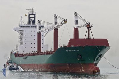
GALLOWAY
Container Ship
Current Trip
| Time Travelled | 2 days |
|---|---|
| Remaining Time | 13 h, 55 mins |
| Distance Travelled | 808.83 nm |
| Remaining Distance | 272.62 nm |
| AVG Speed | 14.5 Knots |
| MAX Speed | 19.8 Knots |
| AVG Wind | 18.4 knots |
| MAX Wind | 28.3 knots |
| MIN Temp | 14.2°C / 57.56°F |
| MAX Temp | 22.7°C / 72.86°F |
| Draught | 8.6 m |
| Position Received | 1 d ago |
Current Position
| Longitude | -54.80987° |
|---|---|
| Latitude | -35.07640° |
| Status | Under way using engine |
| Speed | 19.8 Knots |
| Course | 85.6° |
| Area | South Atlantic Ocean |
| Station | T-AIS |
| Position Received | 1 d ago |
Info
Information
The current position of GALLOWAY is in South Atlantic Ocean with coordinates -35.07640° / -54.80987° as reported on 2024-04-17 13:51 by AIS to our vessel tracker app. The vessel's current speed is 19.8 Knots and is heading at the port of SANTOS. The estimated time of arrival as calculated by MyShipTracking vessel tracking app is 2024-04-19 09:44 LT
The vessel GALLOWAY (IMO: 9306471, MMSI: 636019425) is a Container Ship that was built in 2005 ( 19 years old ). It's sailing under the flag of [LR] Liberia.
In this page you can find informations about the vessels current position, last detected port calls, and current voyage information. If the vessels is not in coverage by AIS you will find the latest position.
The current position of GALLOWAY is detected by our AIS receivers and we are not responsible for the reliability of the data. The last position was recorded while the vessel was in Coverage by the Ais receivers of our vessel tracking app.
The current draught of GALLOWAY as reported by AIS is 8.6 meters
Weather
| Temperature | 22.6°C / 72.68°F |
|---|---|
| Wind Speed | 14 knots |
| Direction | 195° SSW |
| Pressure | 1016.2 hPa |
| Humidity | 56.9 % |
| Cloud Coverage | --- |
Featured Company
Last Port Calls
| Port | Arrival | Departure | Time In Port |
|---|---|---|---|
| 2024-04-14 17:47 | 2024-04-16 15:48 | 1 d | |
| 2024-04-12 07:42 | 2024-04-14 07:40 | 1 d | |
| 2024-04-07 23:02 | 2024-04-08 23:18 | 1 d | |
| 2024-04-05 05:03 | 2024-04-06 06:54 | 1 d | |
| 2024-03-31 13:21 | 2024-04-02 06:52 | 1 d | |
| 2024-03-30 10:59 | 2024-03-31 03:50 | 16 h | |
| 2024-03-24 21:30 | 2024-03-25 18:05 | 20 h | |
| 2024-03-19 09:19 | 2024-03-19 21:13 | 11 h | |
| 2024-03-09 22:01 | 2024-03-10 04:48 | 6 h | |
| 2024-03-02 15:35 | 2024-03-03 02:42 | 11 h |
Most Visited Ports (Last year)
| Port | Arrivals | |
|---|---|---|
| 26 | ||
| 25 | ||
| 14 | ||
| 13 | ||
| 13 | ||
| 12 |
Last Trips
| Origin | Departure | Destination | Arrival | Distance | |
|---|---|---|---|---|---|
| 2024-04-14 04:40 | 2024-04-14 14:47 | 116.67 nm | |||
| 2024-04-08 20:18 | 2024-04-12 04:42 | 1049.25 nm | |||
| 2024-04-06 03:54 | 2024-04-07 20:02 | 191.51 nm | |||
| 2024-04-02 03:52 | 2024-04-05 02:03 | 1061.52 nm | |||
| 2024-03-31 00:50 | 2024-03-31 10:21 | 114.55 nm | |||
| 2024-03-25 15:05 | 2024-03-30 07:59 | 1103.64 nm | |||
| 2024-03-19 18:13 | 2024-03-24 18:30 | 195.52 nm | |||
| 2024-03-10 01:48 | 2024-03-19 06:19 | 2102.67 nm | |||
| 2024-03-02 21:42 | 2024-03-09 19:01 | 2547.96 nm | |||
| 2024-03-02 09:59 | 2024-03-02 10:35 | 1.88 nm |
Events
| Time | Event | Details | Position / Dest | Info |
|---|---|---|---|---|
| 2024-04-17 13:56 | Status Changed | Default Under way using engine |
-35.07540 / -54.77335
SANTOS
|
Speed: 19.8 kn Course: 85.6° |
| 2024-04-17 13:51 | OUT of Coverage |
-35.07640 / -54.80987
South Atlantic Ocean
SANTOS
|
Speed: 19.8 kn Course: 85.6° |
|
| 2024-04-17 13:05 | Change Sea Area | Uruguayan part of the South Atlantic Ocean Uruguayan part of the Rio de La Plata |
-35.08484 / -55.11693
South Atlantic Ocean
SANTOS
|
Speed: 19.5 kn Course: 88.6° |
| 2024-04-17 11:50 | Status Changed | Under way using engine Default |
-35.08657 / -55.60009
SANTOS
|
Speed: 18.5 kn Course: 92° |
| 2024-04-17 11:26 | Status Changed | Default Under way using engine |
-35.08223 / -55.74456
SANTOS
|
Speed: 17.8 kn Course: 97.6° |
| 2024-04-17 11:21 | Status Changed | Under way using engine Default |
-35.07894 / -55.78038
SANTOS
|
Speed: 17.7 kn Course: 97° |
| 2024-04-17 10:49 | Status Changed | Default Under way using engine |
-35.06405 / -55.95307
SANTOS
|
Speed: 4.5 kn Course: 190° |
| 2024-04-17 10:39 | START Moving | 11.73 nm, South East of BUCEO |
-35.05340 / -55.96795
SANTOS
|
Speed: 3.6 kn Course: 201° |
| 2024-04-17 10:01 | STOP Moving | 11.52 nm, South East of BUCEO |
-35.05593 / -55.97812
SANTOS
|
Speed: 0.3 kn Course: 243° |
| 2024-04-17 09:55 | Change Sea Area | Uruguayan part of the Rio de La Plata Argentinean part of the Rio de La Plata |
-35.05451 / -55.97447
Rio de La Plata
SANTOS
|
Speed: 3.9 kn Course: 240.3° |