
GALLOWAY
Container Ship
Current Trip
| Time Travelled | 9 days |
|---|---|
| Remaining Time | 2 days |
| Distance Travelled | 3351.21 nm |
| Remaining Distance | 1057.53 nm |
| AVG Speed | 15.4 Noeuds |
| MAX Speed | 18.8 Noeuds |
| AVG Wind | 12.4 knots |
| MAX Wind | 22 knots |
| MIN Temp | 25°C / 77°F |
| MAX Temp | 29.1°C / 84.38°F |
| Tirant d eau | 9 m |
| Position reçue | 6 d depuis |
Current Position
| Longitude | -61.67283° |
|---|---|
| Latitude | 11.67671° |
| Etat | Under way using engine |
| Vitesse | 15 Noeuds |
| Parcours | 96° |
| Zone | Caribbean Sea |
| Station | T-AIS |
| Position reçue | 6 d depuis |
Info
Information
The current position of GALLOWAY is in Caribbean Sea with coordinates 11.67671° / -61.67283° as reported on 2024-07-20 22:07 by AIS to our vessel tracker app. The vessel's current speed is 15 Noeuds and is heading at the port of PARANAGUA. The estimated time of arrival as calculated by MyShipTracking vessel tracking app is 2024-07-29 18:38 LT
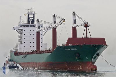
The vessel GALLOWAY (IMO: 9306471, MMSI: 636019425) is a Container Ship that was built in 2005 ( 19 Age ). It's sailing under the flag of [LR] Liberia.
In this page you can find informations about the vessels current position, last detected port calls, and current voyage information. If the vessels is not in coverage by AIS you will find the latest position.
The current position of GALLOWAY is detected by our AIS receivers and we are not responsible for the reliability of the data. The last position was recorded while the vessel was in Coverage by the Ais receivers of our vessel tracking app.
The current draught of GALLOWAY as reported by AIS is 9 meters
Weather
| Temperature | 25.2°C / 77.36°F |
|---|---|
| Wind Speed | 18 knots |
| Direction | 97° E |
| Pressure | 1019.3 hPa |
| Humidity | 68.7 % |
| Cloud Coverage | 97 % |
Featured Company
Last Port Calls
| Port | Arrival | Departure | Time In Port |
|---|---|---|---|
| 2024-07-16 20:36 | 2024-07-17 23:49 | 1 d | |
| 2024-06-29 10:33 | 2024-06-30 06:53 | 20 h | |
| 2024-06-18 09:51 | 2024-06-19 06:16 | 20 h | |
| 2024-06-11 16:11 | 2024-06-13 05:15 | 1 d | |
| 2024-06-09 03:07 | 2024-06-09 19:49 | 16 h | |
| 2024-05-25 03:00 | 2024-05-26 03:13 | 1 d | |
| 2024-05-19 22:53 | 2024-05-20 17:33 | 18 h | |
| 2024-05-17 04:09 | 2024-05-17 23:45 | 19 h | |
| 2024-05-11 16:02 | 2024-05-13 16:20 | 2 d | |
| 2024-05-11 15:08 | 2024-05-11 15:24 | 16 m |
Most Visited Ports (Last year)
| Port | Arrivals | |
|---|---|---|
| 18 | ||
| 17 | ||
| 10 | ||
| 9 | ||
| 8 | ||
| 8 |
Last Trips
| Origin | Departure | Destination | Arrival | Distance | |
|---|---|---|---|---|---|
| 2024-06-30 06:53 | 2024-07-16 20:36 | 4593.42 nm | |||
| 2024-06-19 06:16 | 2024-06-29 10:33 | 4016.47 nm | |||
| 2024-06-13 05:15 | 2024-06-18 09:51 | 1040.26 nm | |||
| 2024-06-09 19:49 | 2024-06-11 16:11 | 285.39 nm | |||
| 2024-05-26 03:13 | 2024-06-09 03:07 | 4463.50 nm | |||
| 2024-05-20 17:33 | 2024-05-25 03:00 | 74.85 nm | |||
| 2024-05-17 23:45 | 2024-05-19 22:53 | 200.46 nm | |||
| 2024-05-13 16:20 | 2024-05-17 04:09 | 1060.06 nm | |||
| 2024-05-11 15:24 | 2024-05-11 16:02 | 0.95 nm | |||
| 2024-05-11 05:01 | 2024-05-11 15:08 | 111.85 nm |
Events
| Heure | Evenement | Détails | Position/ Destination | Info |
|---|---|---|---|---|
| 2024-07-20 22:11 | Etat Changé | Default Under way using engine |
11.67498 / -61.65565
BRPNG
|
Vitesse: 15 kn Parcours: 96° |
| 2024-07-20 22:07 | Hors de la zone couverte |
11.67671 / -61.67283
Caribbean Sea
BRPNG
|
Vitesse: 15 kn Parcours: 96° |
|
| 2024-07-20 20:06 | Etat Changé | Under way using engine Default |
11.72875 / -62.19952
BRPNG
|
Vitesse: 16.1 kn Parcours: 95° |
| 2024-07-20 19:28 | Etat Changé | Default Under way using engine |
11.74189 / -62.37180
BRPNG
|
Vitesse: 16 kn Parcours: 91° |
| 2024-07-20 19:26 | Etat Changé | Under way using engine Default |
11.74218 / -62.38152
BRPNG
|
Vitesse: 16.3 kn Parcours: 90° |
| 2024-07-20 19:26 | Changement de zone | Grenadian part of the Caribbean Sea Colombian part of the Caribbean Sea |
11.74218 / -62.38152
Caribbean Sea
BRPNG
|
Vitesse: 16 kn Parcours: 91° |
| 2024-07-20 19:11 | Dans la zone couverte |
11.74218 / -62.38152
Caribbean Sea
BRPNG
|
Vitesse: 16 kn Parcours: 91° |
|
| 2024-07-18 21:07 | Etat Changé | Default Under way using engine |
11.45909 / -74.44204
BRPNG
|
Vitesse: 17.5 kn Parcours: 62.6° |
| 2024-07-18 20:46 | Hors de la zone couverte |
11.41046 / -74.53518
Caribbean Sea
BRPNG
|
Vitesse: 17.5 kn Parcours: 62.6° |
|
| 2024-07-18 20:11 | Etat Changé | Under way using engine Default |
11.32991 / -74.69244
BRPNG
|
Vitesse: 18 kn Parcours: 64° |