
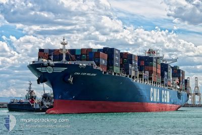
CMA CGM MOLIERE
Container Ship
Current Trip
| Time Travelled | 8 days |
|---|---|
| Remaining Time | --- |
| Distance Travelled | 2880.24 nm |
| Remaining Distance | 1878.13 nm |
| AVG Speed | 14.4 Knopen |
| MAX Speed | 20 Knopen |
| AVG Wind | 17 knots |
| MAX Wind | 31.8 knots |
| MIN Temp | 13.2°C / 55.76°F |
| MAX Temp | 31.3°C / 88.34°F |
| Diepgang | 10.6 M |
| Positie ontvangen | 3 d geleden |
Current Position
| Lengtegraad | -65.63083° |
|---|---|
| Breedtegraat | 33.46350° |
| Status | Under way using engine |
| Snelheid | 15.2 Knopen |
| Koers | 67° |
| Gebied | North Atlantic Ocean |
| Station | T-AIS |
| Positie ontvangen | 3 d geleden |
Info
Information
The current position of CMA CGM MOLIERE is in North Atlantic Ocean with coordinates 33.46350° / -65.63083° as reported on 2024-05-10 18:12 by AIS to our vessel tracker app. The vessel's current speed is 15.2 Knopen and is heading at the port of LE HAVRE. The estimated time of arrival as calculated by MyShipTracking vessel tracking app is 2024-05-24 13:30 LT
The vessel CMA CGM MOLIERE (IMO: 9401099, MMSI: 249917000) is a Container Ship that was built in 2009 ( 15 Jaar oud ). It's sailing under the flag of [MT] Malta.
In this page you can find informations about the vessels current position, last detected port calls, and current voyage information. If the vessels is not in coverage by AIS you will find the latest position.
The current position of CMA CGM MOLIERE is detected by our AIS receivers and we are not responsible for the reliability of the data. The last position was recorded while the vessel was in Coverage by the Ais receivers of our vessel tracking app.
The current draught of CMA CGM MOLIERE as reported by AIS is 10.6 meters
Weather
| Temperature | 15.6°C / 60.08°F |
|---|---|
| Wind Speed | 14 knots |
| Direction | 181° S |
| Pressure | 1026.6 hPa |
| Humidity | 94.4 % |
| Cloud Coverage | 7 % |
Featured Company
Last Port Calls
| Port | Arrival | Departure | Time In Port |
|---|---|---|---|
| 2024-05-04 12:30 | 2024-05-05 10:59 | 22 h | |
| 2024-05-01 16:42 | 2024-05-03 01:56 | 1 d | |
| 2024-04-27 16:32 | 2024-04-28 10:55 | 18 h | |
| 2024-04-20 10:36 | 2024-04-20 23:35 | 12 h | |
| 2024-04-18 12:54 | 2024-04-19 08:18 | 19 h | |
| 2024-04-09 11:17 | 2024-04-10 12:39 | 1 d | |
| 2024-04-06 14:48 | 2024-04-08 02:27 | 1 d | |
| 2024-04-04 22:59 | 2024-04-05 21:55 | 22 h | |
| 2024-04-01 20:23 | 2024-04-03 06:29 | 1 d | |
| 2024-03-10 14:00 | 2024-03-11 10:47 | 20 h |
Most Visited Ports (Last year)
| Port | Arrivals | |
|---|---|---|
| 7 | ||
| 7 | ||
| 7 | ||
| 6 | ||
| 6 | ||
| 6 |
Last Trips
| Origin | Departure | Destination | Arrival | Distance | |
|---|---|---|---|---|---|
| 2024-05-03 01:56 | 2024-05-04 12:30 | 445.71 nm | |||
| 2024-04-28 10:55 | 2024-05-01 16:42 | 513.72 nm | |||
| 2024-04-20 23:35 | 2024-04-27 16:32 | 1512.85 nm | |||
| 2024-04-19 08:18 | 2024-04-20 10:36 | 437.02 nm | |||
| 2024-04-10 12:39 | 2024-04-18 12:54 | 3865.29 nm | |||
| 2024-04-08 02:27 | 2024-04-09 11:17 | 274.11 nm | |||
| 2024-04-05 21:55 | 2024-04-06 14:48 | 275.37 nm | |||
| 2024-04-03 06:29 | 2024-04-04 22:59 | 344.68 nm | |||
| 2024-03-11 10:47 | 2024-04-01 20:23 | 5068.90 nm | |||
| 2024-03-09 10:04 | 2024-03-10 14:00 | 458.63 nm |
Events
| Tijd | Evenement | Details | Positie / Bestemming | Info |
|---|---|---|---|---|
| 2024-05-10 18:17 | Status Changed | Default Under way using engine |
33.47155 / -65.60865
FRLEH
|
Snelheid: 15.2 kn Koers: 67° |
| 2024-05-10 18:12 | Status Changed | Under way using engine Default |
33.46350 / -65.63083
FRLEH
|
Snelheid: 15.3 kn Koers: 67° |
| 2024-05-10 18:12 | Buitenbereik |
33.46350 / -65.63083
North Atlantic Ocean
FRLEH
|
Snelheid: 15.2 kn Koers: 67° |
|
| 2024-05-10 18:08 | Status Changed | Default Under way using engine |
33.45603 / -65.65163
FRLEH
|
Snelheid: 15.3 kn Koers: 66° |
| 2024-05-10 17:31 | Status Changed | Under way using engine Default |
33.39357 / -65.82373
FRLEH
|
Snelheid: 15 kn Koers: 66° |
| 2024-05-10 17:26 | Binnenbereik |
33.39567 / -65.81813
North Atlantic Ocean
FRLEH
|
Snelheid: 15.1 kn Koers: 66° |
|
| 2024-05-10 16:09 | Status Changed | Default Under way using engine |
33.25882 / -66.19227
FRLEH
|
Snelheid: 14.8 kn Koers: 66° |
| 2024-05-10 16:03 | Buitenbereik |
33.24887 / -66.21953
North Atlantic Ocean
FRLEH
|
Snelheid: 14.8 kn Koers: 66° |
|
| 2024-05-10 15:24 | Status Changed | Under way using engine Default |
33.18547 / -66.39358
FRLEH
|
Snelheid: 14.3 kn Koers: 66° |
| 2024-05-10 15:09 | Binnenbereik |
33.18840 / -66.38527
North Atlantic Ocean
FRLEH
|
Snelheid: 14.4 kn Koers: 67° |