
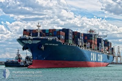
CMA CGM MOLIERE
Container Ship
Current Trip
| Time Travelled | 4 days |
|---|---|
| Remaining Time | --- |
| Distance Travelled | 1240.60 nm |
| Remaining Distance | 142.74 nm |
| AVG Speed | 17.1 Knots |
| MAX Speed | 20.8 Knots |
| AVG Wind | 9.9 knots |
| MAX Wind | 19 knots |
| MIN Temp | 24.1°C / 75.38°F |
| MAX Temp | 29.4°C / 84.92°F |
| Dybgang | 10.7 m |
| Position Modtaget | 3 d siden |
Current Position
| Longitude | -81.02416° |
|---|---|
| Latitude | 23.75820° |
| Status | Under way using engine |
| Fart | 20.4 Knots |
| Kurs | 232° |
| Område | North Atlantic Ocean |
| Station | T-AIS |
| Position Modtaget | 3 d siden |
Info
Information
The current position of CMA CGM MOLIERE is in North Atlantic Ocean with coordinates 23.75820° / -81.02416° as reported on 2024-04-21 13:05 by AIS to our vessel tracker app. The vessel's current speed is 20.4 Knots and is heading at the port of VERACRUZ. The estimated time of arrival as calculated by MyShipTracking vessel tracking app is 2024-04-23 14:00 LT
The vessel CMA CGM MOLIERE (IMO: 9401099, MMSI: 249917000) is a Container Ship that was built in 2009 ( 15 år gamle ). It's sailing under the flag of [MT] Malta.
In this page you can find informations about the vessels current position, last detected port calls, and current voyage information. If the vessels is not in coverage by AIS you will find the latest position.
The current position of CMA CGM MOLIERE is detected by our AIS receivers and we are not responsible for the reliability of the data. The last position was recorded while the vessel was in Coverage by the Ais receivers of our vessel tracking app.
The current draught of CMA CGM MOLIERE as reported by AIS is 10.7 meters
Weather
| Temperature | 25.3°C / 77.54°F |
|---|---|
| Wind Speed | 4 knots |
| Direction | 105° ESE |
| Pressure | 1014.1 hPa |
| Humidity | 90.6 % |
| Cloud Coverage | 38 % |
Featured Company
Last Port Calls
| Port | Arrival | Departure | Time In Port |
|---|---|---|---|
| 2024-04-20 14:36 | 2024-04-21 03:35 | 12 h | |
| 2024-04-18 16:54 | 2024-04-19 12:18 | 19 h | |
| 2024-04-09 09:17 | 2024-04-10 10:39 | 1 d | |
| 2024-04-06 12:48 | 2024-04-08 00:27 | 1 d | |
| 2024-04-04 20:59 | 2024-04-05 19:55 | 22 h | |
| 2024-04-01 18:23 | 2024-04-03 04:29 | 1 d | |
| 2024-03-10 19:00 | 2024-03-11 15:47 | 20 h | |
| 2024-03-08 09:04 | 2024-03-09 16:04 | 1 d | |
| 2024-03-02 20:03 | 2024-03-04 00:12 | 1 d | |
| 2024-02-25 20:43 | 2024-02-26 22:59 | 1 d |
Most Visited Ports (Last year)
| Port | Arrivals | |
|---|---|---|
| 7 | ||
| 6 | ||
| 6 | ||
| 6 | ||
| 6 | ||
| 6 |
Last Trips
| Origin | Departure | Destination | Arrival | Distance | |
|---|---|---|---|---|---|
| 2024-04-19 08:18 | 2024-04-20 10:36 | 437.02 nm | |||
| 2024-04-10 12:39 | 2024-04-18 12:54 | 3865.29 nm | |||
| 2024-04-08 02:27 | 2024-04-09 11:17 | 274.11 nm | |||
| 2024-04-05 21:55 | 2024-04-06 14:48 | 275.37 nm | |||
| 2024-04-03 06:29 | 2024-04-04 22:59 | 344.68 nm | |||
| 2024-03-11 10:47 | 2024-04-01 20:23 | 5068.90 nm | |||
| 2024-03-09 10:04 | 2024-03-10 14:00 | 458.63 nm | |||
| 2024-03-03 18:12 | 2024-03-08 03:04 | 487.83 nm | |||
| 2024-02-26 17:59 | 2024-03-02 14:03 | 1346.17 nm | |||
| 2024-02-24 11:00 | 2024-02-25 15:43 | 435.16 nm |
Events
| Tid | Hændelsen | Detaljer | Position / Dest | Info |
|---|---|---|---|---|
| 2024-04-25 00:05 | START Sejllads | 2.45 nm, North West of VERACRUZ |
19.22325 / -96.16306
MXVER
|
Fart: 5.2 kn Kurs: 123° |
| 2024-04-24 03:14 | STOP Sejllads | 3.21 nm, North West of VERACRUZ |
19.23682 / -96.16936
MXVER
|
Fart: 0.3 kn Kurs: 350° |
| 2024-04-21 13:07 | Status er ændret | Default Under way using engine |
23.75235 / -81.03255
MXVER
|
Fart: 20.4 kn Kurs: 232° |
| 2024-04-21 13:05 | Udenfor Dækning |
23.75820 / -81.02416
North Atlantic Ocean
MXVER
|
Fart: 20.4 kn Kurs: 232° |
|
| 2024-04-21 13:03 | Ændre havområde | Cuban part of the North Atlantic Ocean Bahamas part of the North Atlantic Ocean |
23.76501 / -81.01440
North Atlantic Ocean
MXVER
|
Fart: 20.4 kn Kurs: 232° |
| 2024-04-21 13:03 | Status er ændret | Under way using engine Default |
23.76501 / -81.01440
MXVER
|
Fart: 20.3 kn Kurs: 232° |
| 2024-04-21 12:48 | Status er ændret | Default Under way using engine |
23.81870 / -80.93720
MXVER
|
Fart: 20.2 kn Kurs: 232° |
| 2024-04-21 12:37 | Status er ændret | Under way using engine Default |
23.85542 / -80.88453
MXVER
|
Fart: 20.1 kn Kurs: 231° |
| 2024-04-21 12:28 | Indenfor Dækning |
23.85542 / -80.88453
North Atlantic Ocean
MXVER
|
Fart: 20.1 kn Kurs: 231° |
|
| 2024-04-21 05:55 | Udenfor Dækning |
25.50408 / -79.61978
North Atlantic Ocean
MXVER
|
Fart: 18.5 kn Kurs: 179° |