
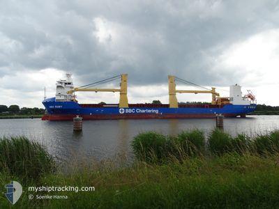
BBC RUBY
Cargo
Current Trip
| Time Travelled | 3 days |
|---|---|
| Remaining Time | --- |
| Distance Travelled | 1060.52 nm |
| Remaining Distance | --- |
| AVG Speed | 14 Knopen |
| MAX Speed | 17.3 Knopen |
| AVG Wind | 6.4 knots |
| MAX Wind | 16 knots |
| MIN Temp | 22.3°C / 72.14°F |
| MAX Temp | 25.6°C / 78.08°F |
| Diepgang | 7 M |
| Positie ontvangen | 2 m geleden |
Current Position
| Lengtegraad | --- |
|---|---|
| Breedtegraat | --- |
| Status | At anchor |
| Snelheid | |
| Koers | 282° |
| Gebied | Persian Gulf |
| Station | T-AIS |
| Positie ontvangen | 2 m geleden |
Info
Information
The current position of BBC RUBY is in Persian Gulf with coordinates 24.77854° / 54.22256° as reported on 2025-12-05 16:51 by AIS to our vessel tracker app. The vessel's current speed is 0 Knopen
The vessel BBC RUBY (IMO: 9563744, MMSI: 305908000) is a Cargo It's sailing under the flag of [AG] Antigua Barbuda.
In this page you can find informations about the vessels current position, last detected port calls, and current voyage information. If the vessels is not in coverage by AIS you will find the latest position.
The current position of BBC RUBY is detected by our AIS receivers and we are not responsible for the reliability of the data. The last position was recorded while the vessel was in Coverage by the Ais receivers of our vessel tracking app.
The current draught of BBC RUBY as reported by AIS is 7 meters
Weather
| Temperature | 25.1°C / 77.18°F |
|---|---|
| Wind Speed | 5 knots |
| Direction | 341° NNW |
| Pressure | 1018.9 hPa |
| Humidity | 61.9 % |
| Cloud Coverage | 94 % |
Featured Company
Last Port Calls
| Port | Arrival | Departure | Time In Port |
|---|---|---|---|
| 2025-11-28 01:41 | 2025-12-02 01:39 | 3 d | |
| 2025-11-16 09:59 | 2025-11-18 01:30 | 1 d | |
| 2025-11-08 17:24 | 2025-11-13 03:39 | 4 d | |
| 2025-10-30 08:18 | 2025-11-01 07:42 | 1 d |
Last Trips
| Origin | Departure | Destination | Arrival | Distance | |
|---|---|---|---|---|---|
| 2025-11-18 01:30 | 2025-11-28 01:41 | 41.50 nm | |||
| 2025-11-13 03:39 | 2025-11-16 09:59 | 253.50 nm | |||
| 2025-11-01 07:42 | 2025-11-08 17:24 | 1325.63 nm | |||
| 2025-09-28 18:15 | 2025-10-30 08:18 | 11491.92 nm |
Events
| Tijd | Evenement | Details | Positie / Bestemming | Info |
|---|---|---|---|---|
| 2025-12-05 15:09 | Status Changed | At anchor Default |
24.77885 / 54.22245
AEMZD
|
Snelheid: Koers: 258° |
| 2025-12-05 15:00 | Status Changed | Default At anchor |
24.77885 / 54.22244
AEMZD
|
Snelheid: Koers: 256° |
| 2025-12-05 14:45 | Status Changed | At anchor Default |
24.77888 / 54.22239
AEMZD
|
Snelheid: Koers: 249° |
| 2025-12-05 14:15 | Status Changed | Default At anchor |
24.77892 / 54.22243
AEMZD
|
Snelheid: Koers: 240° |
| 2025-12-05 13:54 | Status Changed | At anchor Default |
24.77894 / 54.22238
AEMZD
|
Snelheid: Koers: 232° |
| 2025-12-05 13:48 | Status Changed | Default At anchor |
24.77896 / 54.22249
AEMZD
|
Snelheid: Koers: 232° |
| 2025-12-05 07:12 | Status Changed | At anchor Default |
24.77891 / 54.22212
AEMZD
|
Snelheid: Koers: 111° |
| 2025-12-05 07:03 | Status Changed | Default At anchor |
24.77892 / 54.22203
AEMZD
|
Snelheid: Koers: 111° |
| 2025-12-05 05:30 | Status Changed | At anchor Default |
24.77854 / 54.22185
AEMZD
|
Snelheid: 0.2 kn Koers: 12° |
| 2025-12-05 05:18 | Status Changed | Default At anchor |
24.77851 / 54.22198
AEMZD
|
Snelheid: 0.2 kn Koers: 23° |