
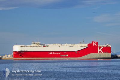
ODIN HIGHWAY
Cargo
Current Trip
JPNGOOFF
| Time Travelled | 4 days |
|---|---|
| Remaining Time | --- |
| Distance Travelled | 9.05 nm |
| Remaining Distance | --- |
| AVG Speed | 14 Noeuds |
| MAX Speed | 14 Noeuds |
| AVG Wind | 7.6 knots |
| MAX Wind | 15 knots |
| MIN Temp | 17.8°C / 64.04°F |
| MAX Temp | 22.7°C / 72.86°F |
| Tirant d eau | 8.1 m |
| Position reçue | 1 h, 42 m depuis |
Current Position
| Longitude | 136.70588° |
|---|---|
| Latitude | 34.87552° |
| Etat | At anchor |
| Vitesse | |
| Parcours | 169° |
| Zone | Philippine Sea |
| Station | T-AIS |
| Position reçue | 1 h, 42 m depuis |
Info
Information
The current position of ODIN HIGHWAY is in Philippine Sea with coordinates 34.87552° / 136.70588° as reported on 2024-06-10 14:54 by AIS to our vessel tracker app. The vessel's current speed is 0 Noeuds
The vessel ODIN HIGHWAY (IMO: 9948152, MMSI: 636023331) is a Cargo It's sailing under the flag of [LR] Liberia.
In this page you can find informations about the vessels current position, last detected port calls, and current voyage information. If the vessels is not in coverage by AIS you will find the latest position.
The current position of ODIN HIGHWAY is detected by our AIS receivers and we are not responsible for the reliability of the data. The last position was recorded while the vessel was in Coverage by the Ais receivers of our vessel tracking app.
The current draught of ODIN HIGHWAY as reported by AIS is 8.1 meters
Weather
| Temperature | 21.3°C / 70.34°F |
|---|---|
| Wind Speed | 7 knots |
| Direction | 165° SSE |
| Pressure | 1009.8 hPa |
| Humidity | 85.3 % |
| Cloud Coverage | 100 % |
Featured Company
Last Trips
Events
| Heure | Evenement | Détails | Position/ Destination | Info |
|---|---|---|---|---|
| 2024-06-10 14:54 | Hors de la zone couverte |
34.87552 / 136.70588
Philippine Sea
|
Vitesse: Parcours: 131.6° |
|
| 2024-06-10 14:54 | Dans la zone couverte |
34.87552 / 136.70588
Philippine Sea
|
Vitesse: Parcours: 131.6° |
|
| 2024-06-10 06:22 | Hors de la zone couverte |
34.87566 / 136.70598
Philippine Sea
|
Vitesse: 0.1 kn Parcours: 189.2° |
|
| 2024-06-10 06:22 | Dans la zone couverte |
34.87566 / 136.70598
Philippine Sea
|
Vitesse: 0.1 kn Parcours: 189.2° |
|
| 2024-06-10 04:46 | Hors de la zone couverte |
34.87579 / 136.70651
Philippine Sea
|
Vitesse: Parcours: 91.8° |
|
| 2024-06-10 04:46 | Dans la zone couverte |
34.87579 / 136.70651
Philippine Sea
|
Vitesse: Parcours: 91.8° |
|
| 2024-06-10 02:09 | Hors de la zone couverte |
34.87477 / 136.70603
Philippine Sea
|
Vitesse: 0.1 kn Parcours: 244.3° |
|
| 2024-06-09 22:02 | Dans la zone couverte |
34.87459 / 136.70629
Philippine Sea
|
Vitesse: Parcours: 253.7° |
|
| 2024-06-09 20:33 | Hors de la zone couverte |
34.87450 / 136.70638
Philippine Sea
|
Vitesse: Parcours: 11.7° |
|
| 2024-06-09 20:27 | Dans la zone couverte |
34.87448 / 136.70621
Philippine Sea
|
Vitesse: Parcours: 131.3° |