
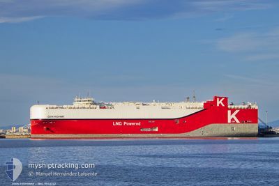
ODIN HIGHWAY
Cargo
Current Trip
| Time Travelled | 35 days |
|---|---|
| Remaining Time | 4 days |
| Distance Travelled | 11494.16 nm |
| Remaining Distance | 2748.42 nm |
| AVG Speed | 16.9 Knots |
| MAX Speed | 20.8 Knots |
| AVG Wind | 10.5 knots |
| MAX Wind | 22.1 knots |
| MIN Temp | 10°C / 50°F |
| MAX Temp | 30.9°C / 87.62°F |
| Dybgang | 8.4 m |
| Position Modtaget | 4 d siden |
Current Position
| Longitude | 104.33479° |
|---|---|
| Latitude | 1.28118° |
| Status | Under way using engine |
| Fart | 13.6 Knots |
| Kurs | 61.9° |
| Område | Singapore Strait |
| Station | T-AIS |
| Position Modtaget | 4 d siden |
Info
Information
The current position of ODIN HIGHWAY is in Singapore Strait with coordinates 1.28118° / 104.33479° as reported on 2024-05-11 11:23 by AIS to our vessel tracker app. The vessel's current speed is 13.6 Knots and is heading at the port of NAGOYA. The estimated time of arrival as calculated by MyShipTracking vessel tracking app is 2024-05-20 06:24 LT
The vessel ODIN HIGHWAY (IMO: 9948152, MMSI: 636023331) is a Cargo It's sailing under the flag of [LR] Liberia.
In this page you can find informations about the vessels current position, last detected port calls, and current voyage information. If the vessels is not in coverage by AIS you will find the latest position.
The current position of ODIN HIGHWAY is detected by our AIS receivers and we are not responsible for the reliability of the data. The last position was recorded while the vessel was in Coverage by the Ais receivers of our vessel tracking app.
The current draught of ODIN HIGHWAY as reported by AIS is 8.4 meters
Weather
| Temperature | 30.2°C / 86.36°F |
|---|---|
| Wind Speed | 10 knots |
| Direction | 89° E |
| Pressure | 1008.5 hPa |
| Humidity | 71.7 % |
| Cloud Coverage | 18 % |
Featured Company
Events
| Tid | Hændelsen | Detaljer | Position / Dest | Info |
|---|---|---|---|---|
| 2024-05-11 11:23 | Udenfor Dækning |
1.28118 / 104.33479
Singapore Strait
JPNGO
|
Fart: 13.6 kn Kurs: 61.9° |
|
| 2024-05-11 11:21 | Ændre havområde | Malaysian part of the Singapore Strait Indonesian part of the Singapore Strait |
1.27792 / 104.32851
Singapore Strait
JPNGO
|
Fart: 13.7 kn Kurs: 63.4° |
| 2024-05-11 11:15 | Ændre havområde | Indonesian part of the Singapore Strait Malaysian part of the Singapore Strait |
1.26838 / 104.30868
Singapore Strait
JPNGO
|
Fart: 12.1 kn Kurs: 71.5° |
| 2024-05-11 10:37 | Ændre havområde | Malaysian part of the Singapore Strait Indonesian part of the Singapore Strait |
1.25886 / 104.16840
Singapore Strait
JPNGO
|
Fart: 13.7 kn Kurs: 81.1° |
| 2024-05-11 10:02 | Destination er ændret | JPNGO SGSIN |
1.24339 / 104.02753
JPNGO
|
Fart: 13.8 kn Kurs: 85° |
| 2024-05-11 09:58 | Dybgangen er ændret | 8.4 7.8 |
1.24259 / 104.01260
SGSIN
|
Fart: 14 kn Kurs: 89.1° |
| 2024-05-11 09:58 | ETA er ændret | 2024/05/20 03:00 2024/06/11 06:30 |
1.24259 / 104.01260
SGSIN
|
Fart: 14 kn Kurs: 89.1° |
| 2024-05-11 09:55 | Status er ændret | Under way using engine At anchor |
1.24253 / 104.00114
SGSIN
|
Fart: 14.2 kn Kurs: 89.9° |
| 2024-05-11 09:46 | Ændre havområde | Indonesian part of the Singapore Strait Singaporean part of the Singapore Strait |
1.24143 / 103.96795
Singapore Strait
|
Fart: 12.5 kn Kurs: 87.3° |
| 2024-05-11 09:13 | START Sejllads | 3.04 nm, East of SINGAPORE |
1.27590 / 103.90184
SGSIN
|
Fart: 4.7 kn Kurs: 96° |