
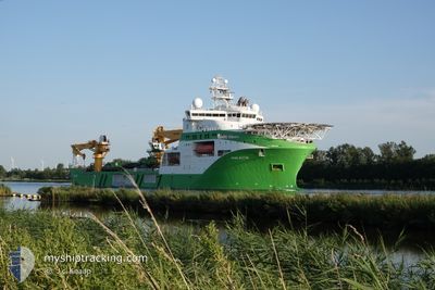
VIKING NEPTUN
Other Type
Current Trip
| Time Travelled | 42 days |
|---|---|
| Remaining Time | --- |
| Distance Travelled | 3378.09 nm |
| Remaining Distance | --- |
| AVG Speed | 9.8 Knots |
| MAX Speed | 14.9 Knots |
| AVG Wind | 16.6 knots |
| MAX Wind | 35 knots |
| MIN Temp | 5.2°C / 41.36°F |
| MAX Temp | 19.8°C / 67.64°F |
| Dybgang | 6.7 m |
| Position Modtaget | 16 m siden |
Current Position
| Longitude | -9.84380° |
|---|---|
| Latitude | 39.86217° |
| Status | Under way using engine |
| Fart | 13.3 Knots |
| Kurs | 358.9° |
| Område | North Atlantic Ocean |
| Station | T-AIS |
| Position Modtaget | 16 m siden |
Info
Information
The current position of VIKING NEPTUN is in North Atlantic Ocean with coordinates 39.86217° / -9.84380° as reported on 2024-05-06 15:35 by AIS to our vessel tracker app. The vessel's current speed is 13.3 Knots and is heading at the port of AMSTERDAM. The estimated time of arrival as calculated by MyShipTracking vessel tracking app is 2024-05-10 06:00 LT
The vessel VIKING NEPTUN (IMO: 9664902, MMSI: 258789000) is a Other Type It's sailing under the flag of [NO] Norway.
In this page you can find informations about the vessels current position, last detected port calls, and current voyage information. If the vessels is not in coverage by AIS you will find the latest position.
The current position of VIKING NEPTUN is detected by our AIS receivers and we are not responsible for the reliability of the data. The last position was recorded while the vessel was in Coverage by the Ais receivers of our vessel tracking app.
The current draught of VIKING NEPTUN as reported by AIS is 6.7 meters
Weather
| Temperature | 15.2°C / 59.36°F |
|---|---|
| Wind Speed | 13 knots |
| Direction | 345° NNW |
| Pressure | 1018.9 hPa |
| Humidity | 72.5 % |
| Cloud Coverage | --- |
Featured Company
Most Visited Ports (Last year)
| Port | Arrivals | |
|---|---|---|
| 7 | ||
| 4 | ||
| 3 | ||
| 1 | ||
| 1 |
Events
| Tid | Hændelsen | Detaljer | Position / Dest | Info |
|---|---|---|---|---|
| 2024-05-06 05:03 | Indenfor Dækning |
37.53747 / -9.49520
North Atlantic Ocean
NLAMS
|
Fart: 13 kn Kurs: 346.5° |
|
| 2024-05-06 03:50 | Udenfor Dækning |
37.27504 / -9.41992
North Atlantic Ocean
NLAMS
|
Fart: 13.3 kn Kurs: 345.3° |
|
| 2024-05-06 03:49 | Indenfor Dækning |
37.27504 / -9.41992
North Atlantic Ocean
NLAMS
|
Fart: 13.3 kn Kurs: 345.3° |
|
| 2024-05-06 02:03 | Udenfor Dækning |
36.88974 / -9.30399
North Atlantic Ocean
NLAMS
|
Fart: 13.2 kn Kurs: 318.3° |
|
| 2024-05-05 19:14 | Fundet i havområde | Portuguese part of the North Atlantic Ocean |
36.31879 / -7.49634
North Atlantic Ocean
NLAMS
|
Fart: 13.6 kn Kurs: 289.6° |
| 2024-05-05 14:55 | Fundet i havområde | Spanish part of the North Atlantic Ocean |
36.00769 / -6.38975
North Atlantic Ocean
NLAMS
|
Fart: 13.3 kn Kurs: 287.7° |
| 2024-05-05 14:55 | Indenfor Dækning |
36.00769 / -6.38975
North Atlantic Ocean
NLAMS
|
Fart: 13.3 kn Kurs: 287.7° |
|
| 2024-05-05 12:58 | Udenfor Dækning |
35.95940 / -5.90021
Strait of Gibraltar
NLAMS
|
Fart: 12.4 kn Kurs: 271.3° |
|
| 2024-05-05 10:40 | Fundet i havområde | Spanish part of the Strait of Gibraltar |
36.00998 / -5.33712
Strait of Gibraltar
NLAMS
|
Fart: 10.6 kn Kurs: 259.9° |
| 2024-05-05 10:37 | Ændre havområde | Gibraltarian part of the Strait of Gibraltar Gibraltarian part of the Alboran Sea |
36.01163 / -5.32522
Strait of Gibraltar
NLAMS
|
Fart: 10.4 kn Kurs: 260.5° |