
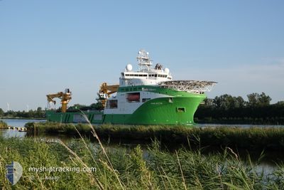
VIKING NEPTUN
Other Type
Current Trip
LE BARCARES FR
| Time Travelled | 26 days |
|---|---|
| Remaining Time | --- |
| Distance Travelled | 2008.32 nm |
| Remaining Distance | --- |
| AVG Speed | 9 Knots |
| MAX Speed | 14.9 Knots |
| AVG Wind | 15 knots |
| MAX Wind | 35 knots |
| MIN Temp | 5.2°C / 41.36°F |
| MAX Temp | 17.5°C / 63.5°F |
| Draught | 7 m |
| Position Received | 9 m ago |
Current Position
| Longitude | -3.79983° |
|---|---|
| Latitude | 36.16340° |
| Status | Under way using engine |
| Speed | 9.2 Knots |
| Course | 83.5° |
| Area | Alboran Sea |
| Station | T-AIS |
| Position Received | 9 m ago |
Info
Information
The current position of VIKING NEPTUN is in Alboran Sea with coordinates 36.16340° / -3.79983° as reported on 2024-04-20 01:32 by AIS to our vessel tracker app. The vessel's current speed is 9.2 Knots
The vessel VIKING NEPTUN (IMO: 9664902, MMSI: 258789000) is a Other Type It's sailing under the flag of [NO] Norway.
In this page you can find informations about the vessels current position, last detected port calls, and current voyage information. If the vessels is not in coverage by AIS you will find the latest position.
The current position of VIKING NEPTUN is detected by our AIS receivers and we are not responsible for the reliability of the data. The last position was recorded while the vessel was in Coverage by the Ais receivers of our vessel tracking app.
The current draught of VIKING NEPTUN as reported by AIS is 7 meters
Weather
| Temperature | 16.7°C / 62.06°F |
|---|---|
| Wind Speed | 17 knots |
| Direction | 107° ESE |
| Pressure | 1015.9 hPa |
| Humidity | 63.6 % |
| Cloud Coverage | 100 % |
Featured Company
Most Visited Ports (Last year)
| Port | Arrivals | |
|---|---|---|
| 7 | ||
| 5 | ||
| 3 | ||
| 1 | ||
| 1 |
Events
| Time | Event | Details | Position / Dest | Info |
|---|---|---|---|---|
| 2024-04-19 17:40 | Change Sea Area | Spanish part of the Alboran Sea Spanish part of the Strait of Gibraltar |
35.97923 / -5.31840
Alboran Sea
LE BARCARES FR
|
Speed: 8.4 kn Course: 83.4° |
| 2024-04-19 17:20 | Change Sea Area | Spanish part of the Strait of Gibraltar Moroccan part of the Strait of Gibraltar |
35.97306 / -5.37793
Strait of Gibraltar
LE BARCARES FR
|
Speed: 8.5 kn Course: 83.4° |
| 2024-04-19 14:33 | Detected in Sea | Moroccan part of the Strait of Gibraltar |
35.90702 / -5.91277
Strait of Gibraltar
LE BARCARES FR
|
Speed: 9.4 kn Course: 87.1° |
| 2024-04-19 12:40 | Detected in Sea | Moroccan part of the North Atlantic Ocean |
35.91111 / -6.28321
North Atlantic Ocean
LE BARCARES FR
|
Speed: 9.8 kn Course: 103.2° |
| 2024-04-19 09:28 | Detected in Sea | Spanish part of the North Atlantic Ocean |
36.04069 / -6.87147
North Atlantic Ocean
LE BARCARES FR
|
Speed: 8.7 kn Course: 104.3° |
| 2024-04-19 09:28 | IN Coverage |
36.04069 / -6.87147
North Atlantic Ocean
LE BARCARES FR
|
Speed: 8.7 kn Course: 104.3° |
|
| 2024-04-19 05:25 | OUT of Coverage |
36.20045 / -7.59764
North Atlantic Ocean
LE BARCARES FR
|
Speed: 8.4 kn Course: 104° |
|
| 2024-04-17 16:51 | Detected in Sea | Portuguese part of the North Atlantic Ocean |
41.31925 / -10.10015
North Atlantic Ocean
LE BARCARES FR
|
Speed: 12 kn Course: 180.5° |
| 2024-04-17 16:51 | IN Coverage |
41.31925 / -10.10015
North Atlantic Ocean
LE BARCARES FR
|
Speed: 12 kn Course: 180.5° |
|
| 2024-04-16 01:26 | OUT of Coverage |
48.79762 / -5.87315
Celtic Sea
LE BARCARES FR
|
Speed: 14.9 kn Course: 203.5° |