
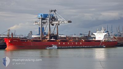
W-NAUTILUS
Bulk Carrier
Current Trip
| Time Travelled | --- |
|---|---|
| Remaining Time | --- |
| Distance Travelled | 2571.21 nm |
| Remaining Distance | 3733.42 nm |
| AVG Speed | 9.1 Knots |
| MAX Speed | 13 Knots |
| AVG Wind | 5.5 knots |
| MAX Wind | 22 knots |
| MIN Temp | 20.6°C / 69.08°F |
| MAX Temp | 31°C / 87.8°F |
| Draught | 7.8 m |
| Position Received | 4 d ago |
Current Position
| Longitude | 103.48626° |
|---|---|
| Latitude | 1.22315° |
| Status | Under way using engine |
| Speed | 12 Knots |
| Course | 283.6° |
| Area | Singapore Strait |
| Station | T-AIS |
| Position Received | 4 d ago |
Info
Information
The current position of W-NAUTILUS is in Singapore Strait with coordinates 1.22315° / 103.48626° as reported on 2024-04-30 02:39 by AIS to our vessel tracker app. The vessel's current speed is 12 Knots and is heading at the port of RICHARDS BAY. The estimated time of arrival as calculated by MyShipTracking vessel tracking app is 2024-05-16 18:30 LT
The vessel W-NAUTILUS (IMO: 9537915, MMSI: 636017030) is a Bulk Carrier that was built in 2011 ( 13 years old ). It's sailing under the flag of [LR] Liberia.
In this page you can find informations about the vessels current position, last detected port calls, and current voyage information. If the vessels is not in coverage by AIS you will find the latest position.
The current position of W-NAUTILUS is detected by our AIS receivers and we are not responsible for the reliability of the data. The last position was recorded while the vessel was in Coverage by the Ais receivers of our vessel tracking app.
The current draught of W-NAUTILUS as reported by AIS is 7.8 meters
Weather
| Temperature | 29.4°C / 84.92°F |
|---|---|
| Wind Speed | 5 knots |
| Direction | 234° SW |
| Pressure | 1008.6 hPa |
| Humidity | 73.8 % |
| Cloud Coverage | 100 % |
Featured Company
Last Port Calls
Most Visited Ports (Last year)
| Port | Arrivals | |
|---|---|---|
| 1 | ||
| 1 | ||
| 1 | ||
| 1 | ||
| 1 | ||
| 1 |
Last Trips
| Origin | Departure | Destination | Arrival | Distance |
|---|
Events
| Time | Event | Details | Position / Dest | Info |
|---|---|---|---|---|
| 2024-04-30 02:43 | Status Changed | Default Under way using engine |
1.22661 / 103.47157
ZA RCB
|
Speed: 12 kn Course: 283.6° |
| 2024-04-30 02:39 | OUT of Coverage |
1.22315 / 103.48626
Singapore Strait
ZA RCB
|
Speed: 12 kn Course: 283.6° |
|
| 2024-04-30 02:08 | Change Sea Area | Malaysian part of the Singapore Strait Indonesian part of the Singapore Strait |
1.20029 / 103.58593
Singapore Strait
ZA RCB
|
Speed: 11.6 kn Course: 283.8° |
| 2024-04-30 02:00 | ETA Changed | 2024/05/16 18:30 2024/05/16 08:45 |
1.19455 / 103.61131
ZA RCB
|
Speed: 11.2 kn Course: 283° |
| 2024-04-30 01:53 | ETA Changed | 2024/05/16 08:45 2024/04/29 08:45 |
1.18935 / 103.63098
ZA RCB
|
Speed: 10.5 kn Course: 284.1° |
| 2024-04-30 01:38 | Change Sea Area | Indonesian part of the Singapore Strait Singaporean part of the Singapore Strait |
1.17671 / 103.67215
Singapore Strait
|
Speed: 10.3 kn Course: 295.9° |
| 2024-04-29 23:03 | START Moving | 4.87 nm, West of TANAH MERAH |
1.28193 / 103.94253
ZA RCB
|
Speed: 3.1 kn Course: 220° |
| 2024-04-29 23:02 | Status Changed | Under way using engine Default |
1.28277 / 103.94300
ZA RCB
|
Speed: 0.1 kn Course: 225° |
| 2024-04-29 23:00 | Status Changed | Default At anchor |
1.28312 / 103.94313
ZA RCB
|
Speed: 0.1 kn Course: 241° |
| 2024-04-29 17:21 | Status Changed | At anchor Default |
1.28264 / 103.93900
ZA RCB
|
Speed: Course: 104° |