
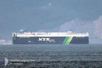
WILD ROSE LEADER
Cargo
Current Trip
| Time Travelled | 26 days |
|---|---|
| Remaining Time | --- |
| Distance Travelled | 5705.07 nm |
| Remaining Distance | 26.88 nm |
| AVG Speed | 11.7 Knots |
| MAX Speed | 18.4 Knots |
| AVG Wind | 11.1 knots |
| MAX Wind | 34.2 knots |
| MIN Temp | 6.6°C / 43.88°F |
| MAX Temp | 29.4°C / 84.92°F |
| Draught | 9.7 m |
| Position Received | 2 d ago |
Current Position
| Longitude | -80.00141° |
|---|---|
| Latitude | 9.92532° |
| Status | Under way using engine |
| Speed | 2.4 Knots |
| Course | 139° |
| Area | Caribbean Sea |
| Station | T-AIS |
| Position Received | 2 d ago |
Info
Information
The current position of WILD ROSE LEADER is in Caribbean Sea with coordinates 9.92532° / -80.00141° as reported on 2024-05-19 22:09 by AIS to our vessel tracker app. The vessel's current speed is 2.4 Knots and is heading at the port of CRISTOBAL. The estimated time of arrival as calculated by MyShipTracking vessel tracking app is 2024-05-18 16:00 LT
The vessel WILD ROSE LEADER (IMO: 9925370, MMSI: 636022333) is a Cargo It's sailing under the flag of [LR] Liberia.
In this page you can find informations about the vessels current position, last detected port calls, and current voyage information. If the vessels is not in coverage by AIS you will find the latest position.
The current position of WILD ROSE LEADER is detected by our AIS receivers and we are not responsible for the reliability of the data. The last position was recorded while the vessel was in Coverage by the Ais receivers of our vessel tracking app.
The current draught of WILD ROSE LEADER as reported by AIS is 9.7 meters
Weather
| Temperature | 26.9°C / 80.42°F |
|---|---|
| Wind Speed | 2 knots |
| Direction | 190° S |
| Pressure | 1006.6 hPa |
| Humidity | 87.7 % |
| Cloud Coverage | 100 % |
Featured Company
Last Port Calls
| Port | Arrival | Departure | Time In Port |
|---|---|---|---|
| 2024-04-24 00:22 | 2024-04-25 22:12 | 1 d | |
| 2024-04-21 21:45 | 2024-04-23 02:01 | 1 d | |
| 2024-04-18 15:14 | 2024-04-21 00:59 | 2 d | |
| 2024-03-16 10:39 | 2024-03-16 17:24 | 6 h |
Most Visited Ports (Last year)
| Port | Arrivals | |
|---|---|---|
| 7 | ||
| 4 | ||
| 3 | ||
| 3 | ||
| 2 | ||
| 2 |
Last Trips
| Origin | Departure | Destination | Arrival | Distance | |
|---|---|---|---|---|---|
| 2024-04-23 04:01 | 2024-04-24 02:22 | 331.35 nm | |||
| 2024-04-21 02:59 | 2024-04-21 23:45 | 312.34 nm | |||
| 2024-03-17 00:24 | 2024-04-18 17:14 | 12717.73 nm | |||
| 2024-02-28 20:25 | 2024-03-16 17:39 | 3745.24 nm |
Events
| Time | Event | Details | Position / Dest | Info |
|---|---|---|---|---|
| 2024-05-21 21:18 | STOP Moving | 1.97 nm, North West of RODMAN |
8.98372 / -79.59071
PA CTB
|
Speed: Course: 142° |
| 2024-05-21 16:59 | START Moving | 8.12 nm, South of CRISTOBAL |
9.21189 / -79.92940
PA CTB
|
Speed: 4.3 kn Course: 146° |
| 2024-05-21 12:07 | STOP Moving | 7.81 nm, South of CRISTOBAL |
9.21731 / -79.93071
PA CTB
|
Speed: 0.2 kn Course: 113° |
| 2024-05-21 11:27 | START Moving | 5.24 nm, South of CRISTOBAL |
9.25856 / -79.91048
PA CTB
|
Speed: 4.5 kn Course: 170° |
| 2024-05-21 09:43 | STOP Moving | 4.27 nm, South of CRISTOBAL |
9.27489 / -79.91280
PA CTB
|
Speed: Course: 170° |
| 2024-05-21 03:59 | START Moving | 19.62 nm, North West of PORTOBELO |
9.81143 / -79.86590
PA CTB
|
Speed: 4.9 kn Course: 185° |
| 2024-05-21 01:57 | STOP Moving | 18.73 nm, North West of PORTOBELO |
9.79786 / -79.85883
PA CTB
|
Speed: 0.3 kn Course: 132° |
| 2024-05-19 22:13 | Status Changed | Default Under way using engine |
9.92674 / -80.00426
PA CTB
|
Speed: 2.4 kn Course: 139° |
| 2024-05-19 22:09 | Change Sea Area | Panamanian part of the Caribbean Sea Montserrat part of the Caribbean Sea |
9.92532 / -80.00141
Caribbean Sea
|
Speed: 2.4 kn Course: 298.8° |
| 2024-05-19 22:09 | OUT of Coverage |
9.92532 / -80.00141
Caribbean Sea
|
Speed: 2.4 kn Course: 298.8° |