
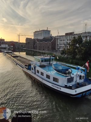
VICTORIE
Cargo
Current Trip
| Trip Time | --- |
|---|---|
| Trip Distance | --- |
| AVG Speed | --- |
| MAX Speed | --- |
| Draught | --- |
| AVG Wind | --- |
| MAX Wind | --- |
| MIN Temp | --- |
| MAX Temp | --- |
| Position Received | 1 d ago |
Current Position
| Longitude | --- |
|---|---|
| Latitude | --- |
| Status | Under way using engine |
| Speed | |
| Course | --- |
| Area | North Sea |
| Station | T-AIS |
| Position Received | 1 d ago |
Info
Information
The current position of VICTORIE is in North Sea with coordinates 52.69695° / 6.16655° as reported on 2024-12-14 18:30 by AIS to our vessel tracker app. The vessel's current speed is 0 Knots and is currently inside the port of MEPPEL.
The vessel VICTORIE (MMSI: 244670571) is a Cargo It's sailing under the flag of [NL] Netherlands.
In this page you can find informations about the vessels current position, last detected port calls, and current voyage information. If the vessels is not in coverage by AIS you will find the latest position.
The current position of VICTORIE is detected by our AIS receivers and we are not responsible for the reliability of the data. The last position was recorded while the vessel was in Coverage by the Ais receivers of our vessel tracking app.
The current draught of VICTORIE as reported by AIS is 0.3 meters
Weather
| Temperature | 5.4°C / 41.72°F |
|---|---|
| Wind Speed | 6 knots |
| Direction | 267° W |
| Pressure | 1017.2 hPa |
| Humidity | 91.7 % |
| Cloud Coverage | 100 % |
Featured Company
Last Port Calls
| Port | Arrival | Departure | Time In Port |
|---|---|---|---|
| 2024-12-12 16:28 | 2024-12-13 09:49 | 17 h | |
| 2024-12-11 14:39 | 2024-12-11 14:57 | 17 m | |
| 2024-12-11 08:27 | 2024-12-11 08:44 | 17 m | |
| 2024-12-11 07:21 | 2024-12-11 07:40 | 19 m | |
| 2024-12-10 21:41 | 2024-12-11 04:17 | 6 h | |
| 2024-12-10 19:41 | 2024-12-10 20:14 | 33 m | |
| 2024-12-10 09:06 | 2024-12-10 09:49 | 43 m | |
| 2024-12-08 22:28 | 2024-12-09 14:18 | 15 h | |
| 2024-12-06 12:11 | 2024-12-06 12:23 | 12 m | |
| 2024-12-02 22:28 | 2024-12-03 13:32 | 15 h |
Most Visited Ports (Last year)
| Port | Arrivals | |
|---|---|---|
| 33 | ||
| 23 | ||
| 22 | ||
| 21 | ||
| 17 | ||
| 15 |
Last Trips
| Origin | Departure | Destination | Arrival | Distance | |
|---|---|---|---|---|---|
| 2024-12-11 15:57 | 2024-12-12 17:28 | 71.51 nm | |||
| 2024-12-11 09:44 | 2024-12-11 15:39 | 4.47 nm | |||
| 2024-12-11 08:40 | 2024-12-11 09:27 | 3.07 nm | |||
| 2024-12-11 05:17 | 2024-12-11 08:21 | 21.95 nm | |||
| 2024-12-10 21:14 | 2024-12-10 22:41 | 7.58 nm | |||
| 2024-12-10 10:49 | 2024-12-10 20:41 | 54.38 nm | |||
| 2024-12-09 15:18 | 2024-12-10 10:06 | 46.18 nm | |||
| 2024-12-06 13:23 | 2024-12-08 23:28 | 34.73 nm | |||
| 2024-12-03 14:32 | 2024-12-06 13:11 | 240.83 nm | |||
| 2024-12-02 09:56 | 2024-12-02 23:28 | 59.48 nm |
Events
| Time | Event | Details | Position / Dest | Info |
|---|---|---|---|---|
| 2024-12-14 18:30 | OUT of Coverage |
52.69695 / 6.16655
North Sea
[NL] MEPPEL
|
Speed: Course: 0° |
|
| 2024-12-14 18:30 | IN Coverage |
52.69695 / 6.16655
North Sea
[NL] MEPPEL
|
Speed: Course: 0° |
|
| 2024-12-13 21:32 | OUT of Coverage |
52.68917 / 6.15735
North Sea
GRONI]INGEN<
|
Speed: 4.8 kn Course: 52.7° |
|
| 2024-12-13 21:32 | Status Changed | Under way using engine Default |
52.68917 / 6.15735
GRONI]INGEN<
|
Speed: 4.6 kn Course: -1° |
| 2024-12-13 21:24 | Status Changed | Default Under way using engine |
52.68058 / 6.14608
GRONI]INGEN<
|
Speed: 4.8 kn Course: 53.2° |
| 2024-12-13 21:08 | Status Changed | Under way using engine Default |
52.66786 / 6.11946
GRONI]INGEN<
|
Speed: 4.8 kn Course: -1° |
| 2024-12-13 21:02 | Status Changed | Default Under way using engine |
52.66473 / 6.10593
GRONI]INGEN<
|
Speed: 4.4 kn Course: 39.5° |
| 2024-12-13 15:53 | START Moving | 4.47 nm, North East of ENKHUIZEN |
52.74405 / 5.39519
GRONI]INGEN<
|
Speed: 3.8 kn Course: 219.4° |
| 2024-12-13 15:38 | Status Changed | Under way using engine Default |
52.74607 / 5.39548
GRONI]INGEN<
|
Speed: Course: -1° |
| 2024-12-13 15:36 | Status Changed | Default Under way using engine |
52.74607 / 5.39552
GRONI]INGEN<
|
Speed: Course: 511° |