
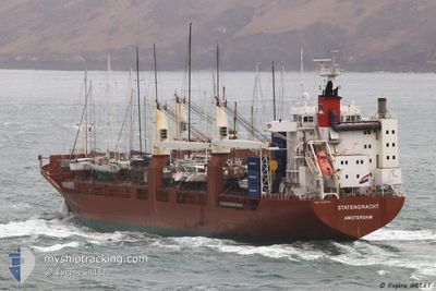
STATENGRACHT
General Cargo
Current Trip
| Time Travelled | 1 day |
|---|---|
| Remaining Time | 1 day |
| Distance Travelled | 239.26 nm |
| Remaining Distance | 627.47 nm |
| AVG Speed | 9.1 Knots |
| MAX Speed | 20.7 Knots |
| AVG Wind | 10.3 knots |
| MAX Wind | 19 knots |
| MIN Temp | 2°C / 35.6°F |
| MAX Temp | 10.3°C / 50.54°F |
| Draught | 7.4 m |
| Position Received | 1 m ago |
Current Position
| Longitude | --- |
|---|---|
| Latitude | --- |
| Status | Under way using engine |
| Speed | 18.4 Knots |
| Course | 95° |
| Area | Baltic Sea |
| Station | T-AIS |
| Position Received | 1 m ago |
Info
Information
The current position of STATENGRACHT is in Baltic Sea with coordinates 54.39933° / 11.95139° as reported on 2025-03-04 20:49 by AIS to our vessel tracker app. The vessel's current speed is 18.4 Knots and is heading at the port of KOTKA. The estimated time of arrival as calculated by MyShipTracking vessel tracking app is 2025-03-06 06:41 LT
The vessel STATENGRACHT (IMO: 9288045, MMSI: 244584000) is a General Cargo that was built in 2004 ( 21 years old ). It's sailing under the flag of [NL] Netherlands.
In this page you can find informations about the vessels current position, last detected port calls, and current voyage information. If the vessels is not in coverage by AIS you will find the latest position.
The current position of STATENGRACHT is detected by our AIS receivers and we are not responsible for the reliability of the data. The last position was recorded while the vessel was in Coverage by the Ais receivers of our vessel tracking app.
The current draught of STATENGRACHT as reported by AIS is 7.4 meters
Weather
| Temperature | 5.3°C / 41.54°F |
|---|---|
| Wind Speed | 19 knots |
| Direction | 250° WSW |
| Pressure | 1021.1 hPa |
| Humidity | 89.6 % |
| Cloud Coverage | 12 % |
Featured Company
Last Port Calls
| Port | Arrival | Departure | Time In Port |
|---|---|---|---|
| 2025-03-03 12:59 | 2025-03-03 21:12 | 8 h | |
| 2025-02-18 11:15 | 2025-02-21 17:16 | 3 d | |
| 2025-02-12 15:45 | 2025-02-14 19:27 | 2 d | |
| 2025-02-11 18:19 | 2025-02-11 18:24 | 5 m | |
| 2025-02-10 08:54 | 2025-02-11 18:07 | 1 d | |
| 2025-02-10 08:32 | 2025-02-10 08:46 | 13 m | |
| 2025-01-15 07:39 | 2025-01-18 07:44 | 3 d | |
| 2025-01-08 11:04 | 2025-01-13 22:41 | 5 d | |
| 2025-01-02 23:28 | 2025-01-05 18:23 | 2 d | |
| 2025-01-01 13:37 | 2025-01-02 12:37 | 22 h |
Most Visited Ports (Last year)
| Port | Arrivals | |
|---|---|---|
| 6 | ||
| 6 | ||
| 5 | ||
| 4 | ||
| 3 | ||
| 3 |
Last Trips
| Origin | Departure | Destination | Arrival | Distance | |
|---|---|---|---|---|---|
| 2025-02-21 17:16 | 2025-03-03 12:59 | 4009.81 nm | |||
| 2025-02-14 19:27 | 2025-02-18 11:15 | 753.85 nm | |||
| 2025-02-11 18:24 | 2025-02-12 15:45 | 317.19 nm | |||
| 2025-02-11 18:07 | 2025-02-11 18:19 | 0.48 nm | |||
| 2025-02-10 08:46 | 2025-02-10 08:54 | 0.23 nm | |||
| 2025-01-18 07:44 | 2025-02-10 08:32 | 5989.50 nm | |||
| 2025-01-13 22:41 | 2025-01-15 07:39 | 474.75 nm | |||
| 2025-01-05 18:23 | 2025-01-08 11:04 | 888.82 nm | |||
| 2025-01-02 12:37 | 2025-01-02 23:28 | 155.41 nm | |||
| 2024-12-20 21:52 | 2025-01-01 13:37 | 4427.32 nm |
Events
| Time | Event | Details | Position / Dest | Info |
|---|---|---|---|---|
| 2025-03-04 19:47 | Change Sea Area | Danish part of the Baltic Sea German part of the Baltic Sea |
54.51786 / 11.42094
Baltic Sea
FIKTK VIA KIEL
|
Speed: 20.1 kn Course: 114.4° |
| 2025-03-04 18:38 | Change Sea Area | German part of the Baltic Sea Danish part of the Baltic Sea |
54.57211 / 10.79031
Baltic Sea
FIKTK VIA KIEL
|
Speed: 19.1 kn Course: 88° |
| 2025-03-04 18:17 | Change Sea Area | Danish part of the Baltic Sea German part of the Baltic Sea |
54.56307 / 10.60019
Baltic Sea
FIKTK VIA KIEL
|
Speed: 18.4 kn Course: 70.3° |
| 2025-03-04 17:44 | ETA Changed | 2025/03/06 10:00 2025/03/06 15:00 |
54.49939 / 10.34442
FIKTK VIA KIEL
|
Speed: 18.4 kn Course: 66.2° |
| 2025-03-04 17:29 | Change Sea Area | German part of the Baltic Sea German part of the North Sea |
54.46414 / 10.27518
Baltic Sea
FIKTK VIA KIEL
|
Speed: 12.6 kn Course: 40.5° |
| 2025-03-04 16:48 | START Moving | 1.32 nm, South West of STICKENHΟRN SPORT |
54.36568 / 10.14460
FIKTK VIA KIEL
|
Speed: 3.4 kn Course: 103° |
| 2025-03-04 16:27 | STOP Moving | 1.37 nm, South West of STICKENHΟRN SPORT |
54.36612 / 10.14144
FIKTK VIA KIEL
|
Speed: 0.3 kn Course: 106° |
| 2025-03-04 15:45 | ETA Changed | 2025/03/06 15:00 2025/03/06 06:00 |
54.36018 / 10.06069
FIKTK VIA KIEL
|
Speed: 4.4 kn Course: 59° |
| 2025-03-04 09:37 | START Moving | 1.58 nm, North of HOCHDONN |
54.04471 / 9.30562
FIKTK VIA KIEL
|
Speed: 3.1 kn Course: 5° |
| 2025-03-04 08:39 | STOP Moving | 1.21 nm, North of HOCHDONN |
54.03871 / 9.30352
FIKTK VIA KIEL
|
Speed: 0.3 kn Course: 8° |