
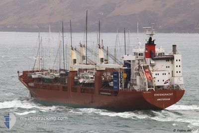
STATENGRACHT
General Cargo
Current Trip
| Time Travelled | 2 days |
|---|---|
| Remaining Time | 1 day |
| Distance Travelled | 767.58 nm |
| Remaining Distance | 681.91 nm |
| AVG Speed | 14.5 Knoten |
| MAX Speed | 18.1 Knoten |
| AVG Wind | 14.9 knots |
| MAX Wind | 23.1 knots |
| MIN Temp | -1.3°C / 29.66°F |
| MAX Temp | 8.1°C / 46.58°F |
| Tiefgang | 8.4 m |
| Position erhalten | Jetzt |
Current Position
| Länge | 10.80837° |
|---|---|
| Breite | 55.60587° |
| Zustand | Under way using engine |
| Geschwindigkeit | 15.5 Knoten |
| Kurs | 338.3° |
| Gebiet | Kattegat |
| Station | T-AIS |
| Position erhalten | Jetzt |
Info
Information
Die aktuelle Position von STATENGRACHT befindet sich in Kattegat mit den Koordinaten 55.60587° / 10.80837°, wie von AIS am 2024-04-19 16:10 an unsere Schiffsverfolgungs-App. Die aktuelle Geschwindigkeit des Schiffes betragt 15.5 Knoten und fahrt in den Hafen von ANTWERP. Die geschatzte Ankunftszeit, berechnet von der MyShipTracking-App zur Schiffsverfolgung, ist 2024-04-21 13:04 LT
Das Schiff STATENGRACHT (IMO: 9288045, MMSI: 244584000) ist General Cargo das wurde im Jahr 2004 ( 20 Jahre alt ) gebaut. Es segelt unter der Flagge [NL] Netherlands.
Auf dieser Seite finden Sie Informationen zur aktuellen Position des Schiffes, zu den zuletzt erkannten Hafenanlaufen und zu aktuellen Reiseinformationen. Wenn die Schiffe nicht von AIS abgedeckt werden, finden Sie die neueste Position.
Die aktuelle Position von STATENGRACHT wird von unseren AIS-Empfangern erkannt und wir sind nicht fur die Zuverlassigkeit der Daten verantwortlich. Die letzte Position wurde von den Ais-Empfangern unserer Schiffsverfolgungs-App aufgezeichnet, wahrend sich das Schiff in Deckung befand.
Der aktuelle Entwurf von STATENGRACHT, wie von AIS gemeldet, betragt 8.4 meter
Weather
| Temperature | 5.1°C / 41.18°F |
|---|---|
| Wind Speed | 22 knots |
| Direction | 58° ENE |
| Pressure | 1003.2 hPa |
| Humidity | 86.8 % |
| Cloud Coverage | 100 % |
Featured Company
Last Port Calls
| Port | Arrival | Departure | Time In Port |
|---|---|---|---|
| 2024-04-13 10:26 | 2024-04-17 11:28 | 4 d | |
| 2024-04-08 05:44 | 2024-04-08 08:13 | 2 h | |
| 2024-03-24 16:41 | 2024-03-26 16:15 | 1 d | |
| 2024-03-18 17:30 | |||
| 2024-02-28 21:08 | 2024-03-05 09:30 | 5 d | |
| 2024-02-10 22:45 | 2024-02-11 17:18 | 18 h | |
| 2024-02-08 18:28 | 2024-02-10 00:28 | 1 d | |
| 2024-02-04 20:29 | 2024-02-06 19:44 | 1 d |
Most Visited Ports (Last year)
| Port | Arrivals | |
|---|---|---|
| 5 | ||
| 5 | ||
| 5 | ||
| 4 | ||
| 4 | ||
| 3 |
Last Trips
| Origin | Departure | Destination | Arrival | Distance | |
|---|---|---|---|---|---|
| 2024-04-08 11:13 | 2024-04-13 12:26 | 233.30 nm | |||
| 2024-03-26 17:15 | 2024-04-08 08:44 | 282.23 nm | |||
| 2024-03-18 18:30 | 2024-03-24 17:41 | 1770.37 nm | |||
| 2024-02-11 12:18 | 2024-02-28 15:08 | 4876.52 nm | |||
| 2024-02-09 19:28 | 2024-02-10 17:45 | 267.17 nm | |||
| 2024-02-06 14:44 | 2024-02-08 13:28 | 721.24 nm | |||
| 2024-01-23 15:49 | 2024-02-04 15:29 | 4287.41 nm |
Events
| Zeit | Ereignis | Details | Position / Ziel | Information |
|---|---|---|---|---|
| 2024-04-19 12:28 | Ändere Seegebiet | Danish part of the Kattegat Danish part of the Baltic Sea |
54.75787 / 10.88364
Kattegat
BEANR
|
Geschwindigkeit: 14.5 kn Kurs: 355° |
| 2024-04-19 11:49 | Ändere Seegebiet | Danish part of the Baltic Sea German part of the Baltic Sea |
54.64461 / 11.04431
Baltic Sea
BEANR
|
Geschwindigkeit: 14.7 kn Kurs: 303.4° |
| 2024-04-19 11:01 | Ändere Seegebiet | German part of the Baltic Sea Danish part of the Baltic Sea |
54.56100 / 11.33375
Baltic Sea
BEANR
|
Geschwindigkeit: 12.8 kn Kurs: 292.5° |
| 2024-04-19 07:40 | Ändere Seegebiet | Danish part of the Baltic Sea German part of the Baltic Sea |
54.68108 / 12.43298
Baltic Sea
BEANR
|
Geschwindigkeit: 14.4 kn Kurs: 234.5° |
| 2024-04-19 07:37 | Ändere Seegebiet | German part of the Baltic Sea Danish part of the Baltic Sea |
54.68811 / 12.44981
Baltic Sea
BEANR
|
Geschwindigkeit: 14.4 kn Kurs: 234.4° |
| 2024-04-19 06:19 | Ändere Seegebiet | Danish part of the Baltic Sea German part of the Baltic Sea |
54.82762 / 12.91580
Baltic Sea
BEANR
|
Geschwindigkeit: 14.6 kn Kurs: 249.2° |
| 2024-04-19 04:01 | Ändere Seegebiet | German part of the Baltic Sea Swedish part of the Baltic Sea |
55.01435 / 13.79933
Baltic Sea
BEANR
|
Geschwindigkeit: 14 kn Kurs: 250.8° |
| 2024-04-19 00:53 | Ändere Seegebiet | Swedish part of the Baltic Sea Danish part of the Kattegat |
55.50630 / 14.75534
Baltic Sea
BEANR
|
Geschwindigkeit: 14.6 kn Kurs: 248.5° |
| 2024-04-18 23:38 | Ändere Seegebiet | Danish part of the Kattegat Swedish part of the Baltic Sea |
55.64520 / 15.23718
Kattegat
BEANR
|
Geschwindigkeit: 14.7 kn Kurs: 241.8° |
| 2024-04-18 17:50 | in Abdeckung |
56.52318 / 17.01584
Baltic Sea
BEANR
|
Geschwindigkeit: 14.5 kn Kurs: 202.7° |