
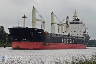
SOLINA
Bulk Carrier
Current Trip
| Time Travelled | 5 days |
|---|---|
| Remaining Time | --- |
| Distance Travelled | 1263.94 nm |
| Remaining Distance | --- |
| AVG Speed | 9.3 Knots |
| MAX Speed | 13.4 Knots |
| AVG Wind | 12 knots |
| MAX Wind | 27 knots |
| MIN Temp | 8.8°C / 47.84°F |
| MAX Temp | 17°C / 62.6°F |
| Draught | 10.3 m |
| Position Received | 2 d ago |
Current Position
| Longitude | --- |
|---|---|
| Latitude | --- |
| Status | Under way using engine |
| Speed | 11.8 Knots |
| Course | 181.5° |
| Area | North Atlantic Ocean |
| Station | T-AIS |
| Position Received | 2 d ago |
Info
Information
The current position of SOLINA is in North Atlantic Ocean with coordinates 37.78905° / -10.06387° as reported on 2025-03-02 13:08 by AIS to our vessel tracker app. The vessel's current speed is 11.8 Knots
The vessel SOLINA (IMO: 9496252, MMSI: 311058500) is a Bulk Carrier that was built in 2012 ( 13 years old ). It's sailing under the flag of [BS] Bahamas.
In this page you can find informations about the vessels current position, last detected port calls, and current voyage information. If the vessels is not in coverage by AIS you will find the latest position.
The current position of SOLINA is detected by our AIS receivers and we are not responsible for the reliability of the data. The last position was recorded while the vessel was in Coverage by the Ais receivers of our vessel tracking app.
The current draught of SOLINA as reported by AIS is 10.3 meters
Weather
| Temperature | 16.8°C / 62.24°F |
|---|---|
| Wind Speed | 7 knots |
| Direction | 232° SW |
| Pressure | 1009.3 hPa |
| Humidity | 72.3 % |
| Cloud Coverage | 16 % |
Featured Company
Last Port Calls
| Port | Arrival | Departure | Time In Port |
|---|---|---|---|
| 2025-02-24 07:37 | 2025-02-26 23:50 | 2 d | |
| 2025-02-10 16:58 | 2025-02-15 23:42 | 5 d | |
| 2025-01-06 04:49 | 2025-01-09 18:18 | 3 d |
Most Visited Ports (Last year)
| Port | Arrivals | |
|---|---|---|
| 5 | ||
| 4 | ||
| 3 | ||
| 3 | ||
| 2 | ||
| 2 |
Last Trips
| Origin | Departure | Destination | Arrival | Distance | |
|---|---|---|---|---|---|
| 2025-02-15 23:42 | 2025-02-24 07:37 | 1765.39 nm | |||
| 2025-01-09 18:18 | 2025-02-10 16:58 | 6264.76 nm | |||
| 2024-12-27 22:50 | 2025-01-06 04:49 | 685.79 nm |
Events
| Time | Event | Details | Position / Dest | Info |
|---|---|---|---|---|
| 2025-03-04 07:48 | STOP Moving | 4.04 nm, West of AGADIR |
30.43727 / -9.70845
MA AGA
|
Speed: 0.3 kn Course: 223° |
| 2025-03-02 13:15 | Status Changed | Default Under way using engine |
37.76451 / -10.06410
MA AGA
|
Speed: 11.8 kn Course: 181.5° |
| 2025-03-02 13:08 | OUT of Coverage |
37.78905 / -10.06387
North Atlantic Ocean
MA AGA
|
Speed: 11.8 kn Course: 181.5° |
|
| 2025-03-02 07:50 | Draught Changed | 10.3 10.2 |
38.54812 / -9.49493
MA AGA
|
Speed: 11.8 kn Course: 228.1° |
| 2025-03-02 07:50 | ETA Changed | 2025/03/04 05:00 2025/03/03 06:00 |
38.54812 / -9.49493
MA AGA
|
Speed: 11.8 kn Course: 228.1° |
| 2025-03-02 06:25 | Draught Changed | 10.2 10.3 |
38.68690 / -9.23239
MA AGA
|
Speed: 10.6 kn Course: 272.5° |
| 2025-03-02 05:49 | START Moving | 0.35 nm, South of LISBOA |
38.70047 / -9.12800
MA AGA
|
Speed: 3.1 kn Course: 278° |
| 2025-03-02 05:21 | Status Changed | Under way using engine At anchor |
38.70151 / -9.12559
MA AGA
|
Speed: 0.1 kn Course: 224° |
| 2025-03-02 03:59 | ETA Changed | 2025/03/03 06:00 2025/03/01 17:00 |
38.70161 / -9.12380
MA AGA
|
Speed: Course: 259° |
| 2025-03-02 03:53 | Destination Changed | MA AGA PT LIS |
38.70156 / -9.12361
MA AGA
|
Speed: 0.1 kn Course: 263° |