
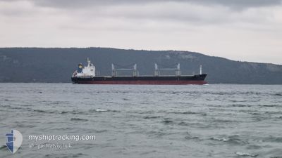
SEA HORSE
Bulk Carrier
Current Trip
| Time Travelled | 21 days |
|---|---|
| Remaining Time | --- |
| Distance Travelled | 2536.24 nm |
| Remaining Distance | --- |
| AVG Speed | 9.4 Knots |
| MAX Speed | 14 Knots |
| AVG Wind | 16.9 knots |
| MAX Wind | 32.5 knots |
| MIN Temp | 2.7°C / 36.86°F |
| MAX Temp | 21.1°C / 69.98°F |
| Draught | 10.5 m |
| Position Received | 8 d ago |
Current Position
| Longitude | --- |
|---|---|
| Latitude | --- |
| Status | Under way using engine |
| Speed | 11.6 Knots |
| Course | 211.3° |
| Area | Aegean Sea |
| Station | T-AIS |
| Position Received | 8 d ago |
Info
Information
The current position of SEA HORSE is in Aegean Sea with coordinates 36.62095° / 23.59021° as reported on 2024-12-02 21:29 by AIS to our vessel tracker app. The vessel's current speed is 11.6 Knots
The vessel SEA HORSE (IMO: 9528029, MMSI: 314776000) is a Bulk Carrier that was built in 2011 ( 13 years old ). It's sailing under the flag of [BB] Barbados.
In this page you can find informations about the vessels current position, last detected port calls, and current voyage information. If the vessels is not in coverage by AIS you will find the latest position.
The current position of SEA HORSE is detected by our AIS receivers and we are not responsible for the reliability of the data. The last position was recorded while the vessel was in Coverage by the Ais receivers of our vessel tracking app.
The current draught of SEA HORSE as reported by AIS is 10.5 meters
Weather
| Temperature | 17.4°C / 63.32°F |
|---|---|
| Wind Speed | 15 knots |
| Direction | 259° W |
| Pressure | 1016.2 hPa |
| Humidity | 51.5 % |
| Cloud Coverage | 100 % |
Featured Company
Most Visited Ports (Last year)
| Port | Arrivals | |
|---|---|---|
| 9 | ||
| 2 | ||
| 1 | ||
| 1 | ||
| 1 | ||
| 1 |
Last Trips
| Origin | Departure | Destination | Arrival | Distance | |
|---|---|---|---|---|---|
| 2024-10-10 13:45 | 2024-11-07 16:07 | 3017.98 nm | |||
| 2024-09-24 07:17 | 2024-10-05 17:31 | 1896.74 nm |
Events
| Time | Event | Details | Position / Dest | Info |
|---|---|---|---|---|
| 2024-12-02 21:30 | Status Changed | Default Under way using engine |
36.61911 / 23.58882
LY MRA
|
Speed: 11.6 kn Course: 211.3° |
| 2024-12-02 21:29 | OUT of Coverage |
36.62095 / 23.59021
Aegean Sea
LY MRA
|
Speed: 11.6 kn Course: 211.3° |
|
| 2024-12-02 21:15 | Status Changed | Under way using engine Default |
36.66022 / 23.61935
LY MRA
|
Speed: 11.3 kn Course: 210° |
| 2024-12-02 20:59 | Status Changed | Default Under way using engine |
36.70571 / 23.65127
LY MRA
|
Speed: 11.5 kn Course: 210° |
| 2024-12-02 08:22 | Status Changed | Under way using engine Default |
38.89293 / 25.15146
LY MRA
|
Speed: 11.7 kn Course: 206° |
| 2024-12-02 08:05 | IN Coverage |
38.89293 / 25.15146
Aegean Sea
LY MRA
|
Speed: 11.7 kn Course: 204° |
|
| 2024-12-02 06:35 | Status Changed | Default Under way using engine |
39.20616 / 25.34274
LY MRA
|
Speed: 11.9 kn Course: 205.2° |
| 2024-12-02 06:28 | Status Changed | Under way using engine Default |
39.22613 / 25.35505
LY MRA
|
Speed: 11.8 kn Course: 204° |
| 2024-12-02 06:28 | OUT of Coverage |
39.22613 / 25.35505
Aegean Sea
LY MRA
|
Speed: 11.9 kn Course: 205.2° |
|
| 2024-12-02 06:00 | Status Changed | Default Under way using engine |
39.31055 / 25.40416
LY MRA
|
Speed: 11.7 kn Course: 204.1° |