
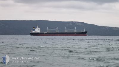
SEA HORSE
Bulk Carrier
Current Trip
| Time Travelled | 28 days |
|---|---|
| Remaining Time | --- |
| Distance Travelled | 2335.32 nm |
| Remaining Distance | --- |
| AVG Speed | 20.3 Knopen |
| MAX Speed | 20.3 Knopen |
| AVG Wind | 11 knots |
| MAX Wind | 24 knots |
| MIN Temp | 7.5°C / 45.5°F |
| MAX Temp | 25.6°C / 78.08°F |
| Diepgang | 6 M |
| Positie ontvangen | 27 d geleden |
Current Position
| Lengtegraad | 29.23834° |
|---|---|
| Breedtegraat | 41.44514° |
| Status | Under way using engine |
| Snelheid | 11.4 Knopen |
| Koers | 5.3° |
| Gebied | Black Sea |
| Station | T-AIS |
| Positie ontvangen | 27 d geleden |
Info
Information
The current position of SEA HORSE is in Black Sea with coordinates 41.44514° / 29.23834° as reported on 2024-05-05 11:35 by AIS to our vessel tracker app. The vessel's current speed is 11.4 Knopen and is heading at the port of CONSTANTA.
The vessel SEA HORSE (IMO: 9528029, MMSI: 314776000) is a Bulk Carrier that was built in 2011 ( 13 Jaar oud ). It's sailing under the flag of [BB] Barbados.
In this page you can find informations about the vessels current position, last detected port calls, and current voyage information. If the vessels is not in coverage by AIS you will find the latest position.
The current position of SEA HORSE is detected by our AIS receivers and we are not responsible for the reliability of the data. The last position was recorded while the vessel was in Coverage by the Ais receivers of our vessel tracking app.
The current draught of SEA HORSE as reported by AIS is 6 meters
Weather
| Temperature | 27.2°C / 80.96°F |
|---|---|
| Wind Speed | 11 knots |
| Direction | 269° W |
| Pressure | 1019.2 hPa |
| Humidity | 31.5 % |
| Cloud Coverage | --- |
Featured Company
Last Port Calls
| Port | Arrival | Departure | Time In Port |
|---|---|---|---|
| 2024-04-30 07:28 | 2024-05-04 14:57 | 4 d | |
| 2024-04-23 20:10 | 2024-04-25 21:46 | 2 d | |
| 2024-04-03 13:25 | 2024-04-08 06:49 | 4 d |
Most Visited Ports (Last year)
| Port | Arrivals | |
|---|---|---|
| 1 | ||
| 1 | ||
| 1 | ||
| 1 | ||
| 1 |
Last Trips
| Origin | Departure | Destination | Arrival | Distance | |
|---|---|---|---|---|---|
| 2024-04-25 21:46 | 2024-04-30 07:28 | 92.65 nm | |||
| 2024-04-08 06:49 | 2024-04-23 20:10 | 416.39 nm | |||
| 2024-03-23 07:17 | 2024-04-03 13:25 | 1959.46 nm |
Events
| Tijd | Evenement | Details | Positie / Bestemming | Info |
|---|---|---|---|---|
| 2024-06-01 11:04 | Start beweging |
45.03343 / 33.97001
RO CND
|
Snelheid: 15.2 kn Koers: 177° |
|
| 2024-06-01 06:24 | Start beweging |
45.04207 / 33.97588
RO CND
|
Snelheid: 54.1 kn Koers: 185° |
|
| 2024-06-01 06:21 | Stop beweging |
45.03962 / 33.96908
RO CND
|
Snelheid: 0.2 kn Koers: 165° |
|
| 2024-06-01 04:42 | Start beweging |
45.04069 / 33.97170
RO CND
|
Snelheid: 39.7 kn Koers: 96° |
|
| 2024-05-25 14:35 | Stop beweging | 15.89 nm, East of SFANTU GHEORGHE |
44.98600 / 29.93947
RO CND
|
Snelheid: 0.3 kn Koers: 59° |
| 2024-05-25 13:44 | Start beweging | 16 nm, East of SFANTU GHEORGHE |
44.98315 / 29.94382
RO CND
|
Snelheid: 9.3 kn Koers: 130° |
| 2024-05-25 07:05 | Stop beweging | 16.01 nm, East of SFANTU GHEORGHE |
44.98613 / 29.94260
RO CND
|
Snelheid: 0.2 kn Koers: 52° |
| 2024-05-24 00:32 | Start beweging |
45.04279 / 33.97417
RO CND
|
Snelheid: 54.1 kn Koers: 186° |
|
| 2024-05-24 00:24 | Stop beweging |
45.03830 / 33.96666
RO CND
|
Snelheid: 0.1 kn Koers: 50° |
|
| 2024-05-23 16:02 | Start beweging |
45.03009 / 33.96258
RO CND
|
Snelheid: 51.8 kn Koers: 186° |