
SAMARY
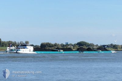
Cargo
Current Trip
RHINE KM 171
| Time Travelled | 2 days |
|---|---|
| Remaining Time | --- |
| Distance Travelled | 190.64 nm |
| Remaining Distance | --- |
| AVG Speed | 5.3 Knots |
| MAX Speed | 6.8 Knots |
| AVG Wind | 6.1 knots |
| MAX Wind | 13 knots |
| MIN Temp | 7.9°C / 46.22°F |
| MAX Temp | 12.1°C / 53.78°F |
| Draught | 2.5 m |
| Position Received | 1 d ago |
Current Position
| Longitude | --- |
|---|---|
| Latitude | --- |
| Status | Under way using engine |
| Speed | 4.5 Knots |
| Course | 243° |
| Area | North Sea |
| Station | T-AIS |
| Position Received | 1 d ago |
Info
Information
The current position of SAMARY is in North Sea with coordinates 49.28681° / 8.48414° as reported on 2025-12-20 08:27 by AIS to our vessel tracker app. The vessel's current speed is 4.5 Knots
The vessel SAMARY (MMSI: 244890469) is a Cargo It's sailing under the flag of [NL] Netherlands.
In this page you can find informations about the vessels current position, last detected port calls, and current voyage information. If the vessels is not in coverage by AIS you will find the latest position.
The current position of SAMARY is detected by our AIS receivers and we are not responsible for the reliability of the data. The last position was recorded while the vessel was in Coverage by the Ais receivers of our vessel tracking app.
The current draught of SAMARY as reported by AIS is 2.5 meters
Weather
| Temperature | 8°C / 46.4°F |
|---|---|
| Wind Speed | 3 knots |
| Direction | 79° E |
| Pressure | 1018 hPa |
| Humidity | 85.4 % |
| Cloud Coverage | 100 % |
Featured Company
Last Port Calls
| Port | Arrival | Departure | Time In Port |
|---|---|---|---|
| 2025-12-18 16:22 | 2025-12-18 17:19 | 57 m | |
| 2025-12-18 03:40 | 2025-12-18 04:05 | 25 m | |
| 2025-12-17 18:37 | 2025-12-17 23:43 | 5 h | |
| 2025-12-17 17:51 | 2025-12-17 18:22 | 31 m | |
| 2025-12-17 13:01 | 2025-12-17 13:54 | 53 m | |
| 2025-12-10 17:02 | 2025-12-10 17:48 | 45 m | |
| 2025-12-10 08:44 | 2025-12-10 09:56 | 1 h | |
| 2025-12-10 02:44 | 2025-12-10 03:16 | 32 m | |
| 2025-12-08 12:58 | 2025-12-09 22:52 | 1 d | |
| 2025-12-08 07:15 | 2025-12-08 07:42 | 27 m |
Last Trips
| Origin | Departure | Destination | Arrival | Distance | |
|---|---|---|---|---|---|
| 2025-12-18 04:05 | 2025-12-18 16:22 | 72.88 nm | |||
| 2025-12-17 23:43 | 2025-12-18 03:40 | 31.11 nm | |||
| 2025-12-17 18:22 | 2025-12-17 18:37 | 2.12 nm | |||
| 2025-12-17 13:54 | 2025-12-17 17:51 | 31.42 nm | |||
| 2025-12-10 17:48 | 2025-12-17 13:01 | 464.34 nm | |||
| 2025-12-10 09:56 | 2025-12-10 17:02 | 40.38 nm | |||
| 2025-12-10 03:16 | 2025-12-10 08:44 | 33.88 nm | |||
| 2025-12-09 22:52 | 2025-12-10 02:44 | 30.60 nm | |||
| 2025-12-08 07:42 | 2025-12-08 12:58 | 40.18 nm | |||
| 2025-12-02 02:30 | 2025-12-08 07:15 | 541.85 nm |
Events
| Time | Event | Details | Position / Dest | Info |
|---|---|---|---|---|
| 2025-12-20 08:27 | OUT of Coverage |
49.28681 / 8.48414
North Sea
|
Speed: 4.5 kn Course: 237.5° |
|
| 2025-12-20 08:27 | Status Changed | Under way using engine Default |
49.28681 / 8.48414
RHINE KM 171
|
Speed: 4.9 kn Course: 228° |
| 2025-12-20 08:25 | Status Changed | Default Under way using engine |
49.28808 / 8.48634
RHINE KM 171
|
Speed: 4.6 kn Course: 205° |
| 2025-12-20 04:53 | Status Changed | Under way using engine Default |
49.49576 / 8.44107
RHINE KM 171
|
Speed: 5.6 kn Course: 166° |
| 2025-12-20 04:53 | IN Coverage |
49.49576 / 8.44107
North Sea
|
Speed: 5.1 kn Course: 171.3° |
|
| 2025-12-20 04:31 | Status Changed | Default Under way using engine |
49.52842 / 8.42857
RHINE KM 171
|
Speed: 4.8 kn Course: 151° |
| 2025-12-20 03:51 | OUT of Coverage |
49.58611 / 8.42092
North Sea
|
Speed: 4.8 kn Course: 151.2° |
|
| 2025-12-20 01:00 | START Moving | 0.94 nm, North of GEINSHEIM |
49.76928 / 8.46872
RHINE KM 171
|
Speed: 4.8 kn Course: 95° |
| 2025-12-20 00:56 | STOP Moving | 0.97 nm, North of GEINSHEIM |
49.76915 / 8.46579
RHINE KM 171
|
Speed: 0.2 kn Course: 84° |
| 2025-12-19 17:55 | IN Coverage |
49.98359 / 7.86447
North Sea
|
Speed: 3.8 kn Course: 166.1° |