
PEARL RIVER
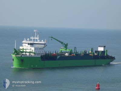
Trailing Suction Hopper Dredger
Current Trip
DREDGING
| Time Travelled | 8 days |
|---|---|
| Remaining Time | --- |
| Distance Travelled | 608.72 nm |
| Remaining Distance | --- |
| AVG Speed | 9.4 Knots |
| MAX Speed | 15.3 Knots |
| AVG Wind | 7.4 knots |
| MAX Wind | 15.6 knots |
| MIN Temp | 23.9°C / 75.02°F |
| MAX Temp | 28.5°C / 83.3°F |
| Draught | 11 m |
| Position Received | Now |
Current Position
| Longitude | 54.54893° |
|---|---|
| Latitude | 24.74486° |
| Status | Restricted manoeuverability |
| Speed | 0.1 Knots |
| Course | 216° |
| Area | Persian Gulf |
| Station | T-AIS |
| Position Received | Now |
Info
Information
The current position of PEARL RIVER is in Persian Gulf with coordinates 24.74486° / 54.54893° as reported on 2024-04-26 08:43 by AIS to our vessel tracker app. The vessel's current speed is 0.1 Knots
The vessel PEARL RIVER (IMO: 9051014, MMSI: 210245000) is a Trailing Suction Hopper Dredger that was built in 1994 ( 30 years old ). It's sailing under the flag of [CY] Cyprus.
In this page you can find informations about the vessels current position, last detected port calls, and current voyage information. If the vessels is not in coverage by AIS you will find the latest position.
The current position of PEARL RIVER is detected by our AIS receivers and we are not responsible for the reliability of the data. The last position was recorded while the vessel was in Coverage by the Ais receivers of our vessel tracking app.
The current draught of PEARL RIVER as reported by AIS is 11 meters
Weather
| Temperature | 26.5°C / 79.7°F |
|---|---|
| Wind Speed | 8 knots |
| Direction | 4° N |
| Pressure | 1008.1 hPa |
| Humidity | 66.8 % |
| Cloud Coverage | --- |
Featured Company
Events
| Time | Event | Details | Position / Dest | Info |
|---|---|---|---|---|
| 2024-04-26 08:05 | STOP Moving | 7.46 nm, South West of KHALIFA |
24.74540 / 54.54943
DREDGING
|
Speed: 0.3 kn Course: 206° |
| 2024-04-26 02:19 | START Moving | 7.36 nm, South West of KHALIFA |
24.74647 / 54.55086
DREDGING
|
Speed: 3.3 kn Course: 346° |
| 2024-04-25 23:26 | STOP Moving | 7.48 nm, South West of KHALIFA |
24.74483 / 54.54947
DREDGING
|
Speed: 0.3 kn Course: 204° |
| 2024-04-25 18:43 | START Moving | 7.11 nm, South West of KHALIFA |
24.74662 / 54.55605
DREDGING
|
Speed: 3.2 kn Course: 246° |
| 2024-04-25 16:57 | Status Changed | Restricted manoeuverability Default |
24.74614 / 54.55834
DREDGING
|
Speed: Course: 122° |
| 2024-04-25 16:56 | Status Changed | Default Restricted manoeuverability |
24.74614 / 54.55833
DREDGING
|
Speed: Course: 123° |
| 2024-04-25 16:49 | Status Changed | Restricted manoeuverability Default |
24.74614 / 54.55833
DREDGING
|
Speed: Course: 123° |
| 2024-04-25 16:36 | Status Changed | Default Restricted manoeuverability |
24.74619 / 54.55825
DREDGING
|
Speed: Course: 124° |
| 2024-04-25 16:10 | Status Changed | Restricted manoeuverability Default |
24.74611 / 54.55831
DREDGING
|
Speed: Course: 124° |
| 2024-04-25 16:08 | Status Changed | Default Restricted manoeuverability |
24.74616 / 54.55832
DREDGING
|
Speed: Course: 124° |