
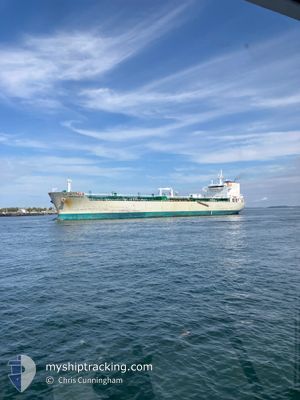
NOR'EASTER
Oil/Chemical Tanker
Current Trip
| Time Travelled | 1 day |
|---|---|
| Remaining Time | --- |
| Distance Travelled | 291.07 nm |
| Remaining Distance | --- |
| AVG Speed | 9.6 Knots |
| MAX Speed | 14.5 Knots |
| AVG Wind | 10.1 knots |
| MAX Wind | 28 knots |
| MIN Temp | -4.4°C / 24.08°F |
| MAX Temp | 2.8°C / 37.04°F |
| Draught | 10.4 m |
| Position Received | 3 m ago |
Current Position
| Longitude | --- |
|---|---|
| Latitude | --- |
| Status | At anchor |
| Speed | |
| Course | 133° |
| Area | North Atlantic Ocean |
| Station | T-AIS |
| Position Received | 3 m ago |
Info
Information
The current position of NOR'EASTER is in North Atlantic Ocean with coordinates 42.34252° / -70.96634° as reported on 2025-12-24 01:44 by AIS to our vessel tracker app. The vessel's current speed is 0 Knots
The vessel NOR'EASTER (IMO: 9350642, MMSI: 538002783) is a Oil/Chemical Tanker that was built in 2007 ( 18 years old ). It's sailing under the flag of [MH] Marshall Is.
In this page you can find informations about the vessels current position, last detected port calls, and current voyage information. If the vessels is not in coverage by AIS you will find the latest position.
The current position of NOR'EASTER is detected by our AIS receivers and we are not responsible for the reliability of the data. The last position was recorded while the vessel was in Coverage by the Ais receivers of our vessel tracking app.
The current draught of NOR'EASTER as reported by AIS is 10.4 meters
Weather
| Temperature | 0.6°C / 33.08°F |
|---|---|
| Wind Speed | 5 knots |
| Direction | 146° SE |
| Pressure | 1015.2 hPa |
| Humidity | 99.3 % |
| Cloud Coverage | 100 % |
Featured Company
Last Port Calls
| Port | Arrival | Departure | Time In Port |
|---|---|---|---|
| 2025-12-21 00:05 | 2025-12-22 00:32 | 1 d | |
| 2025-12-17 06:33 | 2025-12-18 17:31 | 1 d | |
| 2025-12-15 19:04 | 2025-12-16 09:29 | 14 h | |
| 2025-12-12 14:20 | 2025-12-14 13:42 | 1 d | |
| 2025-12-10 11:14 | 2025-12-11 09:01 | 21 h | |
| 2025-12-08 13:40 | 2025-12-09 14:37 | 1 d | |
| 2025-12-07 12:12 | |||
| 2025-12-06 08:59 | |||
| 2025-12-01 21:19 | 2025-12-03 21:03 | 1 d | |
| 2025-11-28 14:47 | 2025-11-30 21:43 | 2 d |
Most Visited Ports (Last year)
| Port | Arrivals | |
|---|---|---|
| 50 | ||
| 34 | ||
| 16 | ||
| 9 | ||
| 6 | ||
| 2 |
Last Trips
| Origin | Departure | Destination | Arrival | Distance | |
|---|---|---|---|---|---|
| 2025-12-18 17:31 | 2025-12-21 00:05 | 362.64 nm | |||
| 2025-12-16 09:29 | 2025-12-17 06:33 | 228.25 nm | |||
| 2025-12-14 13:42 | 2025-12-15 19:04 | 293.86 nm | |||
| 2025-12-11 09:01 | 2025-12-12 14:20 | 109.45 nm | |||
| 2025-12-09 14:37 | 2025-12-10 11:14 | 228.64 nm | |||
| 2025-12-07 12:12 | 2025-12-08 13:40 | 208.31 nm | |||
| 2025-11-30 21:43 | 2025-12-01 21:19 | 292.71 nm | |||
| 2025-11-27 04:33 | 2025-11-28 14:47 | 289.39 nm | |||
| 2025-11-25 01:25 | 2025-11-26 16:19 | 294.33 nm | |||
| 2025-11-22 10:46 | 2025-11-23 16:59 | 5.73 nm |
Events
| Time | Event | Details | Position / Dest | Info |
|---|---|---|---|---|
| 2025-12-23 15:29 | Status Changed | At anchor Default |
42.34079 / -70.96695
USBOS
|
Speed: 0.4 kn Course: 38° |
| 2025-12-23 15:26 | Status Changed | Default At anchor |
42.34051 / -70.96661
USBOS
|
Speed: 0.4 kn Course: 20° |
| 2025-12-23 13:50 | STOP Moving | 1.63 nm, South of WINTHROP |
42.34288 / -70.96531
USBOS
|
Speed: 0.3 kn Course: 156° |
| 2025-12-23 13:17 | Status Changed | At anchor Under way using engine |
42.34023 / -70.96449
USBOS
|
Speed: 0.7 kn Course: 0° |
| 2025-12-23 11:47 | START Moving | 6.64 nm, North East of WINTHROP |
42.42304 / -70.84307
USBOS
|
Speed: 3.1 kn Course: 15° |
| 2025-12-23 11:43 | Status Changed | Under way using engine At anchor |
42.42195 / -70.84176
USBOS
|
Speed: 0.3 kn Course: 280° |
| 2025-12-23 11:06 | Status Changed | At anchor Default |
42.42187 / -70.84160
USBOS
|
Speed: Course: 256° |
| 2025-12-23 11:03 | Status Changed | Default At anchor |
42.42189 / -70.84158
USBOS
|
Speed: Course: 257° |
| 2025-12-23 10:54 | Status Changed | At anchor Default |
42.42188 / -70.84157
USBOS
|
Speed: Course: 259° |
| 2025-12-23 10:51 | Status Changed | Default At anchor |
42.42187 / -70.84159
USBOS
|
Speed: Course: 259° |