
MUTARE
Not available
Current Trip
| Time Travelled | 3 days |
|---|---|
| Remaining Time | --- |
| Distance Travelled | 54.69 nm |
| Remaining Distance | --- |
| AVG Speed | 7.8 Knots |
| MAX Speed | 10.6 Knots |
| AVG Wind | 8.6 knots |
| MAX Wind | 13 knots |
| MIN Temp | 7.1°C / 44.78°F |
| MAX Temp | 11.4°C / 52.52°F |
| Draught | 2 m |
| Position Received | Now |
Current Position
| Longitude | --- |
|---|---|
| Latitude | --- |
| Status | Under way using engine |
| Speed | 9.7 Knots |
| Course | 309.7° |
| Area | North Sea |
| Station | T-AIS |
| Position Received | Now |
Info
Information
The current position of MUTARE is in North Sea with coordinates 51.30218° / 4.28003° as reported on 2025-12-16 03:38 by AIS to our vessel tracker app. The vessel's current speed is 9.7 Knots and is heading at the port of GOES.
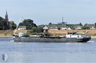
The vessel MUTARE (MMSI: 244740762) is a Not available It's sailing under the flag of [NL] Netherlands.
In this page you can find informations about the vessels current position, last detected port calls, and current voyage information. If the vessels is not in coverage by AIS you will find the latest position.
The current position of MUTARE is detected by our AIS receivers and we are not responsible for the reliability of the data. The last position was recorded while the vessel was in Coverage by the Ais receivers of our vessel tracking app.
The current draught of MUTARE as reported by AIS is 2 meters
Weather
| Temperature | 8.8°C / 47.84°F |
|---|---|
| Wind Speed | 8 knots |
| Direction | 152° SSE |
| Pressure | 1009.5 hPa |
| Humidity | 88.3 % |
| Cloud Coverage | 100 % |
Featured Company
Last Port Calls
| Port | Arrival | Departure | Time In Port |
|---|---|---|---|
| 2025-12-12 10:34 | 2025-12-12 13:04 | 2 h | |
| 2025-12-12 00:13 | 2025-12-12 09:04 | 8 h | |
| 2025-12-10 16:27 | 2025-12-11 09:14 | 16 h | |
| 2025-12-09 14:11 | 2025-12-09 16:05 | 1 h | |
| 2025-12-08 22:23 | 2025-12-09 12:45 | 14 h | |
| 2025-12-03 20:35 | 2025-12-04 14:25 | 17 h | |
| 2025-12-02 18:08 | 2025-12-02 21:08 | 2 h | |
| 2025-12-02 08:36 | 2025-12-02 08:44 | 8 m | |
| 2025-12-01 19:51 | 2025-12-01 22:09 | 2 h | |
| 2025-11-30 22:30 | 2025-12-01 10:15 | 11 h |
Last Trips
| Origin | Departure | Destination | Arrival | Distance | |
|---|---|---|---|---|---|
| 2025-12-12 09:04 | 2025-12-12 10:34 | 11.13 nm | |||
| 2025-12-11 09:14 | 2025-12-12 00:13 | 74.79 nm | |||
| 2025-12-09 16:05 | 2025-12-10 16:27 | 54.46 nm | |||
| 2025-12-09 12:45 | 2025-12-09 14:11 | 12.14 nm | |||
| 2025-12-04 14:25 | 2025-12-08 22:23 | 97.51 nm | |||
| 2025-12-02 21:08 | 2025-12-03 20:35 | 58.93 nm | |||
| 2025-12-02 08:44 | 2025-12-02 18:08 | 34.32 nm | |||
| 2025-12-01 22:09 | 2025-12-02 08:36 | 22.80 nm | |||
| 2025-12-01 10:15 | 2025-12-01 19:51 | 26.81 nm | |||
| 2025-11-30 20:53 | 2025-11-30 22:30 | 11.12 nm |
Events
| Time | Event | Details | Position / Dest | Info |
|---|---|---|---|---|
| 2025-12-16 02:19 | Destination Changed | GOES TEMSE |
51.19150 / 4.33352
GOES
|
Speed: 10.5 kn Course: 31° |
| 2025-12-16 01:59 | IN Coverage |
51.14476 / 4.32783
North Sea
|
Speed: 6 kn Course: 11.5° |
|
| 2025-12-16 00:15 | OUT of Coverage |
51.14019 / 4.32599
North Sea
|
Speed: Course: 511° |
|
| 2025-12-16 00:00 | IN Coverage |
51.14021 / 4.32598
North Sea
|
Speed: Course: 511° |
|
| 2025-12-15 16:04 | OUT of Coverage |
51.14005 / 4.32594
North Sea
|
Speed: 0.2 kn Course: 511° |
|
| 2025-12-15 16:04 | STOP Moving | 0.43 nm, South West of HEMIKSEM |
51.14005 / 4.32594
TEMSE
|
Speed: 0.2 kn Course: 511° |
| 2025-12-15 15:09 | START Moving | 3.04 nm, West of RUPELMONDE |
51.12001 / 4.20850
TEMSE
|
Speed: 6.5 kn Course: 43.6° |
| 2025-12-15 14:16 | IN Coverage |
51.11143 / 4.19749
North Sea
|
Speed: 0.5 kn Course: 210.3° |
|
| 2025-12-15 12:33 | Status Changed | Moored Under way using engine |
51.10922 / 4.19477
TEMSE
|
Speed: 0.4 kn Course: 511° |
| 2025-12-15 12:05 | OUT of Coverage |
51.10753 / 4.19234
North Sea
|
Speed: 0.4 kn Course: 39.4° |