
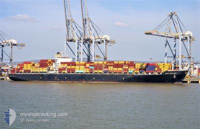
MSC ORIANE
Container Ship
Current Trip
CIABJ
| Time Travelled | 12 h, 27 mins |
|---|---|
| Remaining Time | --- |
| Distance Travelled | 211.61 nm |
| Remaining Distance | --- |
| AVG Speed | 17.1 Knots |
| MAX Speed | 18.7 Knots |
| AVG Wind | 10.8 knots |
| MAX Wind | 15 knots |
| MIN Temp | 26.3°C / 79.34°F |
| MAX Temp | 27.7°C / 81.86°F |
| Draught | 15 m |
| Position Received | 4 d ago |
Current Position
| Longitude | --- |
|---|---|
| Latitude | --- |
| Status | Under way using engine |
| Speed | 15.1 Knots |
| Course | 176.1° |
| Area | North Atlantic Ocean |
| Station | T-AIS |
| Position Received | 4 d ago |
Info
Information
The current position of MSC ORIANE is in North Atlantic Ocean with coordinates 11.80228° / -17.59730° as reported on 2026-01-03 09:23 by AIS to our vessel tracker app. The vessel's current speed is 15.1 Knots
The vessel MSC ORIANE (IMO: 9372482, MMSI: 353289000) is a Container Ship that was built in 2008 ( 18 years old ). It's sailing under the flag of [PA] Panama.
In this page you can find informations about the vessels current position, last detected port calls, and current voyage information. If the vessels is not in coverage by AIS you will find the latest position.
The current position of MSC ORIANE is detected by our AIS receivers and we are not responsible for the reliability of the data. The last position was recorded while the vessel was in Coverage by the Ais receivers of our vessel tracking app.
The current draught of MSC ORIANE as reported by AIS is 15 meters
Weather
| Temperature | 27.3°C / 81.14°F |
|---|---|
| Wind Speed | 10 knots |
| Direction | 235° SW |
| Pressure | 1012.7 hPa |
| Humidity | 77.3 % |
| Cloud Coverage | 91 % |
Featured Company
Last Port Calls
| Port | Arrival | Departure | Time In Port |
|---|---|---|---|
| 2026-01-06 07:02 | 2026-01-06 23:15 | 16 h | |
| 2025-12-25 20:44 | 2025-12-28 05:11 | 2 d | |
| 2025-12-24 00:56 | 2025-12-24 18:48 | 17 h | |
| 2025-12-22 12:24 | 2025-12-22 21:21 | 8 h | |
| 2025-12-11 13:43 | 2025-12-13 03:11 | 1 d | |
| 2025-12-09 10:43 | 2025-12-11 03:34 | 1 d | |
| 2025-12-05 06:53 | 2025-12-06 08:57 | 1 d | |
| 2025-12-01 21:21 | 2025-12-03 17:13 | 1 d | |
| 2025-11-28 19:01 | 2025-11-29 10:13 | 15 h | |
| 2025-11-23 22:35 | 2025-11-24 20:02 | 21 h |
Last Trips
| Origin | Departure | Destination | Arrival | Distance | |
|---|---|---|---|---|---|
| 2025-12-28 05:11 | 2026-01-06 07:02 | 3782.95 nm | |||
| 2025-12-24 18:48 | 2025-12-25 20:44 | 224.53 nm | |||
| 2025-12-22 21:21 | 2025-12-24 00:56 | 181.70 nm | |||
| 2025-12-13 03:11 | 2025-12-22 12:24 | 3760.63 nm | |||
| 2025-12-11 03:34 | 2025-12-11 13:43 | 167.45 nm | |||
| 2025-12-06 08:57 | 2025-12-09 10:43 | 431.71 nm | |||
| 2025-12-03 17:13 | 2025-12-05 06:53 | 183.51 nm | |||
| 2025-11-29 10:13 | 2025-12-01 21:21 | 120.09 nm | |||
| 2025-11-24 20:02 | 2025-11-28 19:01 | 510.15 nm | |||
| 2025-11-17 11:59 | 2025-11-23 22:35 | 2018.89 nm |
Events
| Time | Event | Details | Position / Dest | Info |
|---|---|---|---|---|
| 2026-01-06 23:15 | PORT DEPARTURE |
|
5.24358 / -3.99499
CIABJ
|
Speed: 7.6 kn Course: 130° |
| 2026-01-06 22:51 | START Moving |
5.27278 / -4.02252
[CI] ABIDJAN
|
Speed: 3.2 kn Course: 184° |
|
| 2026-01-06 07:35 | STOP Moving |
5.28283 / -4.01838
[CI] ABIDJAN
|
Speed: 0.1 kn Course: 2° |
|
| 2026-01-06 07:02 | PORT ARRIVAL |
|
5.25556 / -4.01038
[CI] ABIDJAN
|
Speed: 11.1 kn Course: 300° |
| 2026-01-03 09:28 | Status Changed | Default Under way using engine |
11.77667 / -17.59500
CIABJ
|
Speed: 15.1 kn Course: 176.1° |
| 2026-01-03 09:23 | OUT of Coverage |
11.80228 / -17.59730
North Atlantic Ocean
CIABJ
|
Speed: 15.1 kn Course: 176.1° |
|
| 2026-01-03 09:18 | Change Sea Area | Guinea Bissau part of the North Atlantic Ocean Senegalese part of the North Atlantic Ocean |
11.82218 / -17.59876
North Atlantic Ocean
CIABJ
|
Speed: 15.2 kn Course: 175.4° |
| 2026-01-03 09:17 | Status Changed | Under way using engine Default |
11.82599 / -17.59907
CIABJ
|
Speed: 15 kn Course: 176° |
| 2026-01-03 09:17 | IN Coverage |
11.82218 / -17.59876
North Atlantic Ocean
CIABJ
|
Speed: 15.2 kn Course: 175.4° |
|
| 2026-01-03 07:55 | OUT of Coverage |
12.17329 / -17.62977
North Atlantic Ocean
CIABJ
|
Speed: 15.3 kn Course: 175° |