
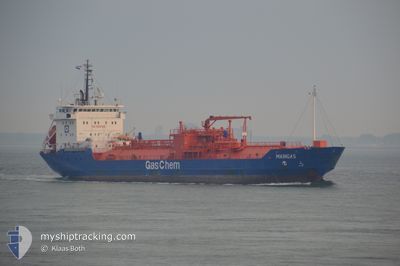
MAINGAS
Lpg Tanker
Current Trip
| Trip Time | 5 days |
|---|---|
| Trip Distance | 217.08 nm |
| AVG Speed | 7.9 Knots |
| MAX Speed | 11.9 Knots |
| Draught | 5.3 m |
| AVG Wind | 19.3 knots |
| MAX Wind | 25 knots |
| MIN Temp | 4°C / 39.2°F |
| MAX Temp | 8.2°C / 46.76°F |
| Position Received | 1 d ago |
Current Position
| Longitude | -0.06681° |
|---|---|
| Latitude | 53.60888° |
| Status | Under way using engine |
| Speed | 5.8 Knots |
| Course | 292.8° |
| Area | North Sea |
| Station | T-AIS |
| Position Received | 1 d ago |
Info
Information
The current position of MAINGAS is in North Sea with coordinates 53.60888° / -0.06681° as reported on 2024-04-25 08:17 by AIS to our vessel tracker app. The vessel's current speed is 5.8 Knots and is currently inside the port of IMMINGHAM.
The vessel MAINGAS (IMO: 9108843, MMSI: 636016595) is a Lpg Tanker that was built in 2001 ( 23 years old ). It's sailing under the flag of [LR] Liberia.
In this page you can find informations about the vessels current position, last detected port calls, and current voyage information. If the vessels is not in coverage by AIS you will find the latest position.
The current position of MAINGAS is detected by our AIS receivers and we are not responsible for the reliability of the data. The last position was recorded while the vessel was in Coverage by the Ais receivers of our vessel tracking app.
The current draught of MAINGAS as reported by AIS is 5.3 meters
Weather
| Temperature | 8.1°C / 46.58°F |
|---|---|
| Wind Speed | 7 knots |
| Direction | 28° NNE |
| Pressure | 1004.7 hPa |
| Humidity | 68.9 % |
| Cloud Coverage | 97 % |
Featured Company
Last Port Calls
| Port | Arrival | Departure | Time In Port |
|---|---|---|---|
| 2024-04-25 09:22 | |||
| 2024-04-18 20:24 | 2024-04-20 07:03 | 1 d | |
| 2024-04-08 01:17 | 2024-04-10 09:37 | 2 d | |
| 2024-04-01 21:58 | 2024-04-02 12:32 | 14 h | |
| 2024-03-30 09:11 | 2024-03-31 10:55 | 1 d | |
| 2024-03-22 22:32 | 2024-03-23 17:03 | 18 h | |
| 2024-03-16 12:12 | 2024-03-16 17:10 | 4 h | |
| 2024-03-06 18:56 | 2024-03-14 17:02 | 7 d | |
| 2024-03-03 15:57 | 2024-03-04 12:14 | 20 h | |
| 2024-03-01 14:42 | 2024-03-02 19:35 | 1 d |
Last Trips
| Origin | Departure | Destination | Arrival | Distance | |
|---|---|---|---|---|---|
| 2024-04-20 09:03 | 2024-04-25 10:22 | 217.08 nm | |||
| 2024-04-10 10:37 | 2024-04-18 22:24 | 1351.28 nm | |||
| 2024-04-02 14:32 | 2024-04-08 02:17 | 257.20 nm | |||
| 2024-03-31 11:55 | 2024-04-01 23:58 | 210.54 nm | |||
| 2024-03-23 18:03 | 2024-03-30 09:11 | 212.03 nm | |||
| 2024-03-16 18:10 | 2024-03-22 23:32 | 295.02 nm | |||
| 2024-03-14 18:02 | 2024-03-16 13:12 | 71.55 nm | |||
| 2024-03-04 13:14 | 2024-03-06 19:56 | 334.94 nm | |||
| 2024-03-02 19:35 | 2024-03-03 16:57 | 226.36 nm | |||
| 2024-02-16 01:26 | 2024-03-01 14:42 | 476.00 nm |
Events
| Time | Event | Details | Position / Dest | Info |
|---|---|---|---|---|
| 2024-04-25 09:42 | STOP Moving |
53.64806 / -.20831
[GB] IMMINGHAM
|
Speed: 0.2 kn Course: 324° |
|
| 2024-04-25 09:22 | PORT ARRIVAL |
|
53.64458 / -.20139
[GB] IMMINGHAM
|
Speed: 3.4 kn Course: 315° |
| 2024-04-25 08:23 | Status Changed | Default Under way using engine |
53.61205 / -.08174
GB IMM
|
Speed: 5.8 kn Course: 292.8° |
| 2024-04-25 08:17 | OUT of Coverage |
53.60888 / -.06682
North Sea
GB IMM
|
Speed: 5.8 kn Course: 292.8° |
|
| 2024-04-25 07:39 | ETA Changed | 2024/04/25 09:30 2024/04/25 10:00 |
53.58698 / .03732
GB IMM
|
Speed: 6.8 kn Course: 295.5° |
| 2024-04-25 07:14 | ETA Changed | 2024/04/25 10:00 2024/04/21 07:30 |
53.56687 / .10618
GB IMM
|
Speed: 6.2 kn Course: 292° |
| 2024-04-25 07:06 | Status Changed | Under way using engine Default |
53.56121 / .12386
GB IMM
|
Speed: 5.2 kn Course: 299° |
| 2024-04-25 06:52 | IN Coverage |
53.56195 / .12187
North Sea
|
Speed: 5 kn Course: 302° |
|
| 2024-04-25 05:28 | START Moving | 17.39 nm, East of GRIMSBY |
53.57809 / .41791
GB IMM
|
Speed: 4.2 kn Course: 230° |
| 2024-04-21 06:07 | STOP Moving | 17.43 nm, East of GRIMSBY |
53.58400 / .41898
GB IMM
|
Speed: 0.3 kn Course: 4° |