
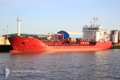
KEY BAY
Oil/Chemical Tanker
Current Trip
| Time Travelled | 1 day |
|---|---|
| Remaining Time | --- |
| Distance Travelled | 340.92 nm |
| Remaining Distance | --- |
| AVG Speed | 10.8 Knots |
| MAX Speed | 13.1 Knots |
| AVG Wind | 15 knots |
| MAX Wind | 28.8 knots |
| MIN Temp | 5.2°C / 41.36°F |
| MAX Temp | 9.1°C / 48.38°F |
| Draught | 5.4 m |
| Position Received | 3 m ago |
Current Position
| Longitude | --- |
|---|---|
| Latitude | --- |
| Status | Moored |
| Speed | |
| Course | 100° |
| Area | Norwegian Sea |
| Station | T-AIS |
| Position Received | 3 m ago |
Info
Information
The current position of KEY BAY is in Norwegian Sea with coordinates 61.58577° / 4.99471° as reported on 2025-12-10 08:28 by AIS to our vessel tracker app. The vessel's current speed is 0 Knots
The vessel KEY BAY (IMO: 9291561, MMSI: 236446000) is a Oil/Chemical Tanker that was built in 2004 ( 21 years old ). It's sailing under the flag of [GI] Gibraltar.
In this page you can find informations about the vessels current position, last detected port calls, and current voyage information. If the vessels is not in coverage by AIS you will find the latest position.
The current position of KEY BAY is detected by our AIS receivers and we are not responsible for the reliability of the data. The last position was recorded while the vessel was in Coverage by the Ais receivers of our vessel tracking app.
The current draught of KEY BAY as reported by AIS is 5.4 meters
Weather
| Temperature | 8.5°C / 47.3°F |
|---|---|
| Wind Speed | 20 knots |
| Direction | 193° SSW |
| Pressure | 989.5 hPa |
| Humidity | 89.8 % |
| Cloud Coverage | 100 % |
Featured Company
Last Port Calls
| Port | Arrival | Departure | Time In Port |
|---|---|---|---|
| 2025-12-07 12:09 | 2025-12-08 14:31 | 1 d | |
| 2025-12-02 07:17 | 2025-12-04 04:48 | 1 d | |
| 2025-11-30 14:24 | 2025-11-30 19:35 | 5 h | |
| 2025-11-26 10:47 | 2025-11-27 04:38 | 17 h | |
| 2025-11-13 18:48 | 2025-11-15 05:00 | 1 d | |
| 2025-11-09 01:17 | 2025-11-11 23:33 | 2 d | |
| 2025-11-06 15:52 | 2025-11-09 00:39 | 2 d | |
| 2025-11-05 08:20 | 2025-11-06 15:17 | 1 d | |
| 2025-11-03 23:47 | 2025-11-05 07:30 | 1 d | |
| 2025-10-31 19:18 | 2025-11-01 17:23 | 22 h |
Most Visited Ports (Last year)
| Port | Arrivals | |
|---|---|---|
| 8 | ||
| 7 | ||
| 6 | ||
| 5 | ||
| 4 | ||
| 4 |
Last Trips
| Origin | Departure | Destination | Arrival | Distance | |
|---|---|---|---|---|---|
| 2025-12-04 04:48 | 2025-12-07 12:09 | 384.60 nm | |||
| 2025-11-30 19:35 | 2025-12-02 07:17 | 246.82 nm | |||
| 2025-11-27 04:38 | 2025-11-30 14:24 | 762.72 nm | |||
| 2025-11-15 05:00 | 2025-11-26 10:47 | 2187.81 nm | |||
| 2025-11-11 23:33 | 2025-11-13 18:48 | 521.68 nm | |||
| 2025-11-09 00:39 | 2025-11-09 01:17 | 4.08 nm | |||
| 2025-11-06 15:17 | 2025-11-06 15:52 | 4.67 nm | |||
| 2025-11-05 07:30 | 2025-11-05 08:20 | 5.21 nm | |||
| 2025-11-01 17:23 | 2025-11-03 23:47 | 537.35 nm | |||
| 2025-10-28 12:12 | 2025-10-31 19:18 | 974.41 nm |
Events
| Time | Event | Details | Position / Dest | Info |
|---|---|---|---|---|
| 2025-12-09 21:40 | Status Changed | Moored Under way using engine |
61.58576 / 4.99470
NOFRO
|
Speed: 0.1 kn Course: 99° |
| 2025-12-09 21:34 | STOP Moving | 1.42 nm, South West of FLORO |
61.58571 / 4.99450
NOFRO
|
Speed: 0.1 kn Course: 98° |
| 2025-12-09 14:37 | Draught Changed | 5.4 5.2 |
61.88259 / 2.44582
NOFRO
|
Speed: 12.1 kn Course: 90° |
| 2025-12-09 14:37 | Destination Changed | NOFRO ISNES |
61.88259 / 2.44582
NOFRO
|
Speed: 12.1 kn Course: 90° |
| 2025-12-09 14:37 | ETA Changed | 2025/12/09 20:30 2025/11/29 22:00 |
61.88259 / 2.44582
NOFRO
|
Speed: 12.1 kn Course: 90° |
| 2025-12-09 13:20 | IN Coverage |
61.89923 / 1.90766
Norwegian Sea
|
Speed: 12.4 kn Course: 92° |
|
| 2025-12-08 14:31 | START Moving | 0.7 nm, South East of FUGLAFJORDUR |
62.23176 / -6.79332
ISNES
|
Speed: 5.6 kn Course: 129° |
| 2025-12-08 14:31 | PORT DEPARTURE |
|
62.23176 / -6.79332
ISNES
|
Speed: 0.6 kn Course: 151° |
| 2025-12-07 12:09 | PORT ARRIVAL |
|
62.23309 / -6.79975
[FO] FUGLAFJORDUR
|
Speed: 4.8 kn Course: 258° |
| 2025-12-04 04:48 | PORT DEPARTURE |
|
63.44029 / -20.19668
ISNES
|
Speed: Course: 269° |