
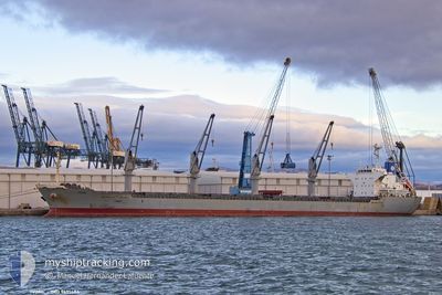
IVONE
Cargo
Current Trip
| Time Travelled | 1 day |
|---|---|
| Remaining Time | 2 h, 32 mins |
| Distance Travelled | 421.42 nm |
| Remaining Distance | 43.23 nm |
| AVG Speed | 11.9 Knots |
| MAX Speed | 13.5 Knots |
| AVG Wind | 9.1 knots |
| MAX Wind | 21.3 knots |
| MIN Temp | 16.4°C / 61.52°F |
| MAX Temp | 21.9°C / 71.42°F |
| Draught | 5.6 m |
| Position Received | 19 h, 36 m ago |
Current Position
| Longitude | --- |
|---|---|
| Latitude | --- |
| Status | Under way using engine |
| Speed | 13.2 Knots |
| Course | 70.2° |
| Area | Persian Gulf |
| Station | T-AIS |
| Position Received | 19 h, 36 m ago |
Info
Information
The current position of IVONE is in Persian Gulf with coordinates 26.22622° / 55.64690° as reported on 2025-12-21 14:50 by AIS to our vessel tracker app. The vessel's current speed is 13.2 Knots and is heading at the port of SOHAR. The estimated time of arrival as calculated by MyShipTracking vessel tracking app is 2025-12-22 12:58 LT
The vessel IVONE (IMO: 9691486, MMSI: 256451000) is a Cargo It's sailing under the flag of [MT] Malta.
In this page you can find informations about the vessels current position, last detected port calls, and current voyage information. If the vessels is not in coverage by AIS you will find the latest position.
The current position of IVONE is detected by our AIS receivers and we are not responsible for the reliability of the data. The last position was recorded while the vessel was in Coverage by the Ais receivers of our vessel tracking app.
The current draught of IVONE as reported by AIS is 5.6 meters
Weather
| Temperature | 21.9°C / 71.42°F |
|---|---|
| Wind Speed | 3 knots |
| Direction | 123° ESE |
| Pressure | 1018.8 hPa |
| Humidity | 46.1 % |
| Cloud Coverage | 4 % |
Featured Company
Last Port Calls
| Port | Arrival | Departure | Time In Port |
|---|---|---|---|
| 2025-12-19 08:06 | 2025-12-20 15:55 | 1 d | |
| 2025-12-16 16:45 | 2025-12-18 09:32 | 1 d | |
| 2025-11-26 02:42 | 2025-12-02 13:51 | 6 d | |
| 2025-10-18 07:07 | 2025-10-22 03:29 | 3 d |
Most Visited Ports (Last year)
| Port | Arrivals | |
|---|---|---|
| 3 | ||
| 1 | ||
| 1 | ||
| 1 | ||
| 1 | ||
| 1 |
Last Trips
| Origin | Departure | Destination | Arrival | Distance | |
|---|---|---|---|---|---|
| 2025-12-18 13:32 | 2025-12-19 11:06 | 263.53 nm | |||
| 2025-12-02 19:21 | 2025-12-16 20:45 | 2910.43 nm | |||
| 2025-10-22 11:29 | 2025-11-26 08:12 | 6253.46 nm | |||
| 2025-09-28 21:36 | 2025-10-18 15:07 | 3496.26 nm |
Events
| Time | Event | Details | Position / Dest | Info |
|---|---|---|---|---|
| 2025-12-21 14:58 | Status Changed | Default Under way using engine |
26.23576 / 55.67759
OM SOH
|
Speed: 13.2 kn Course: 70.2° |
| 2025-12-21 14:50 | OUT of Coverage |
26.22622 / 55.64690
Persian Gulf
OM SOH
|
Speed: 13.2 kn Course: 70.2° |
|
| 2025-12-21 13:14 | Draught Changed | 5.6 5.9 |
26.11539 / 55.30230
OM SOH
|
Speed: 11.9 kn Course: 73.8° |
| 2025-12-21 13:14 | Destination Changed | OM SOH QA UMS |
26.11539 / 55.30230
OM SOH
|
Speed: 11.9 kn Course: 73.8° |
| 2025-12-21 13:14 | ETA Changed | 2025/12/22 03:00 2025/12/19 03:00 |
26.11539 / 55.30230
OM SOH
|
Speed: 11.9 kn Course: 73.8° |
| 2025-12-21 13:08 | Change Sea Area | Iranian part of the Persian Gulf United Arab Emirates part of the Persian Gulf |
26.10948 / 55.28036
Persian Gulf
|
Speed: 11.4 kn Course: 78.1° |
| 2025-12-21 13:04 | Status Changed | Under way using engine Default |
26.10901 / 55.26696
QA UMS
|
Speed: 11.8 kn Course: 102° |
| 2025-12-21 13:02 | IN Coverage |
26.10948 / 55.28036
Persian Gulf
|
Speed: 11.4 kn Course: 78.1° |
|
| 2025-12-20 15:55 | PORT DEPARTURE |
|
24.93688 / 51.59553
QA UMS
|
Speed: 5 kn Course: 174° |
| 2025-12-20 15:53 | START Moving |
24.94093 / 51.59455
[QA] MESAIEED
|
Speed: 5 kn Course: 174° |