
HELENA
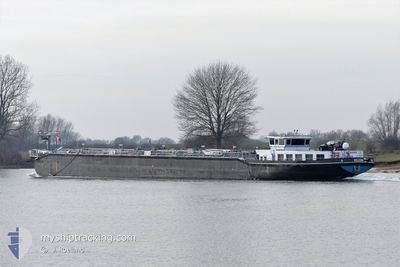
Tanker
Current Trip
| Time Travelled | 3 days |
|---|---|
| Remaining Time | 6 h, 25 mins |
| Distance Travelled | 14.94 nm |
| Remaining Distance | 54.50 nm |
| AVG Speed | 6.7 Knots |
| MAX Speed | 8.2 Knots |
| AVG Wind | 6.5 knots |
| MAX Wind | 8.3 knots |
| MIN Temp | 19.9°C / 67.82°F |
| MAX Temp | 20.9°C / 69.62°F |
| Draught | 1.4 m |
| Position Received | 2 h, 52 m ago |
Current Position
| Longitude | 4.29879° |
|---|---|
| Latitude | 51.11136° |
| Status | Under way using engine |
| Speed | |
| Course | --- |
| Area | North Sea |
| Station | T-AIS |
| Position Received | 2 h, 52 m ago |
Info
Information
The current position of HELENA is in North Sea with coordinates 51.11136° / 4.29879° as reported on 2024-05-13 17:10 by AIS to our vessel tracker app. The vessel's current speed is 0 Knots and is heading at the port of MOERDIJK. The estimated time of arrival as calculated by MyShipTracking vessel tracking app is 2024-05-14 02:27 LT
The vessel HELENA (MMSI: 244690366) is a Tanker It's sailing under the flag of [NL] Netherlands.
In this page you can find informations about the vessels current position, last detected port calls, and current voyage information. If the vessels is not in coverage by AIS you will find the latest position.
The current position of HELENA is detected by our AIS receivers and we are not responsible for the reliability of the data. The last position was recorded while the vessel was in Coverage by the Ais receivers of our vessel tracking app.
The current draught of HELENA as reported by AIS is 1.4 meters
Weather
| Temperature | 19.9°C / 67.82°F |
|---|---|
| Wind Speed | 7 knots |
| Direction | 180° S |
| Pressure | 1008 hPa |
| Humidity | 72.6 % |
| Cloud Coverage | 96 % |
Featured Company
Last Port Calls
| Port | Arrival | Departure | Time In Port |
|---|---|---|---|
| 2024-05-10 07:37 | 2024-05-10 11:28 | 3 h | |
| 2024-05-09 04:12 | 2024-05-09 23:19 | 19 h | |
| 2024-05-08 18:30 | 2024-05-09 04:03 | 9 h | |
| 2024-05-08 01:47 | 2024-05-08 11:44 | 9 h | |
| 2024-05-07 22:56 | 2024-05-07 23:54 | 57 m | |
| 2024-05-07 07:44 | 2024-05-07 18:36 | 10 h | |
| 2024-05-05 04:34 | 2024-05-07 06:53 | 2 d | |
| 2024-05-01 12:26 | 2024-05-03 17:58 | 2 d | |
| 2024-04-30 08:48 | 2024-05-01 10:03 | 1 d | |
| 2024-04-29 18:37 | 2024-04-30 04:03 | 9 h |
Last Trips
| Origin | Departure | Destination | Arrival | Distance | |
|---|---|---|---|---|---|
| 2024-05-10 01:19 | 2024-05-10 09:37 | 61.72 nm | |||
| 2024-05-09 06:03 | 2024-05-09 06:12 | 1.50 nm | |||
| 2024-05-08 13:44 | 2024-05-08 20:30 | 63.25 nm | |||
| 2024-05-08 01:54 | 2024-05-08 03:47 | 21.64 nm | |||
| 2024-05-07 20:36 | 2024-05-08 00:56 | 46.26 nm | |||
| 2024-05-07 08:53 | 2024-05-07 09:44 | 4.24 nm | |||
| 2024-05-03 19:58 | 2024-05-05 06:34 | 153.39 nm | |||
| 2024-05-01 12:03 | 2024-05-01 14:26 | 22.69 nm | |||
| 2024-04-30 06:03 | 2024-04-30 10:48 | 36.61 nm | |||
| 2024-04-26 17:15 | 2024-04-29 20:37 | 125.75 nm |
Events
| Time | Event | Details | Position / Dest | Info |
|---|---|---|---|---|
| 2024-05-13 17:10 | OUT of Coverage |
51.11136 / 4.29879
North Sea
MOERDIJK
|
Speed: Course: 511° |
|
| 2024-05-13 16:50 | STOP Moving | 0.9 nm, South East of RUPELMONDE |
51.11127 / 4.29953
MOERDIJK
|
Speed: 0.3 kn Course: 511° |
| 2024-05-13 16:12 | Destination Changed | MOERDIJK FELUY |
51.07264 / 4.36476
MOERDIJK
|
Speed: 6.9 kn Course: 347.5° |
| 2024-05-13 16:12 | ETA Changed | 2024/05/14 07:38 2024/05/11 10:42 |
51.07264 / 4.36476
MOERDIJK
|
Speed: 6.9 kn Course: 347.5° |
| 2024-05-13 15:54 | IN Coverage |
51.04688 / 4.36166
North Sea
|
Speed: 7.4 kn Course: 6.1° |
|
| 2024-05-10 13:26 | OUT of Coverage |
51.03497 / 4.35814
North Sea
FELUY
|
Speed: 7.6 kn Course: 193.4° |
|
| 2024-05-10 12:39 | START Moving | 0.75 nm, South East of RUPELMONDE |
51.11500 / 4.30115
FELUY
|
Speed: 5.7 kn Course: 196.3° |
| 2024-05-10 12:26 | STOP Moving | 0.67 nm, South East of RUPELMONDE |
51.11767 / 4.30244
FELUY
|
Speed: Course: 511° |
| 2024-05-10 12:17 | START Moving | 0.66 nm, East of RUPELMONDE |
51.12414 / 4.30594
FELUY
|
Speed: 6.2 kn Course: 212.2° |
| 2024-05-10 12:09 | STOP Moving | 0.77 nm, East of RUPELMONDE |
51.12571 / 4.30876
FELUY
|
Speed: 0.1 kn Course: 511° |