
DIOR
Cargo
Current Trip
ASCHACH
| Time Travelled | 2 h, 38 mins |
|---|---|
| Remaining Time | --- |
| Distance Travelled | 12.26 nm |
| Remaining Distance | --- |
| AVG Speed | 5.8 Knots |
| MAX Speed | 6.6 Knots |
| AVG Wind | 1.9 knots |
| MAX Wind | 4 knots |
| MIN Temp | 2.5°C / 36.5°F |
| MAX Temp | 3.2°C / 37.76°F |
| Draught | 1.6 m |
| Position Received | 1 m ago |
Current Position
| Longitude | --- |
|---|---|
| Latitude | --- |
| Status | Under way using engine |
| Speed | 2.6 Knots |
| Course | --- |
| Area | North Sea |
| Station | T-AIS |
| Position Received | 1 m ago |
Info
Information
The current position of DIOR is in North Sea with coordinates 50.08805° / 8.59178° as reported on 2025-12-06 08:34 by AIS to our vessel tracker app. The vessel's current speed is 2.6 Knots
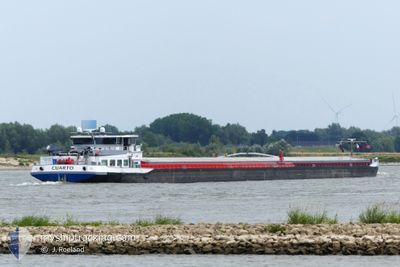
The vessel DIOR (MMSI: 244820092) is a Cargo It's sailing under the flag of [NL] Netherlands.
In this page you can find informations about the vessels current position, last detected port calls, and current voyage information. If the vessels is not in coverage by AIS you will find the latest position.
The current position of DIOR is detected by our AIS receivers and we are not responsible for the reliability of the data. The last position was recorded while the vessel was in Coverage by the Ais receivers of our vessel tracking app.
The current draught of DIOR as reported by AIS is 1.6 meters
Weather
| Temperature | 3.1°C / 37.58°F |
|---|---|
| Wind Speed | 2 knots |
| Direction | 217° SW |
| Pressure | 1009.7 hPa |
| Humidity | 83.8 % |
| Cloud Coverage | 100 % |
Featured Company
Last Port Calls
| Port | Arrival | Departure | Time In Port |
|---|---|---|---|
| 2025-12-06 06:31 | 2025-12-06 06:58 | 26 m | |
| 2025-12-05 00:04 | 2025-12-05 01:05 | 1 h | |
| 2025-12-04 15:10 | 2025-12-04 16:35 | 1 h | |
| 2025-12-01 23:08 | 2025-12-04 11:49 | 2 d | |
| 2025-12-01 20:59 | 2025-12-01 21:26 | 26 m | |
| 2025-11-30 07:31 | 2025-12-01 16:59 | 1 d | |
| 2025-11-30 03:21 | 2025-11-30 03:52 | 31 m | |
| 2025-11-29 04:39 | 2025-11-29 23:11 | 18 h | |
| 2025-11-28 08:17 | 2025-11-28 13:05 | 4 h | |
| 2025-11-28 00:45 | 2025-11-28 00:58 | 13 m |
Most Visited Ports (Last year)
| Port | Arrivals | |
|---|---|---|
| 18 | ||
| 17 | ||
| 16 | ||
| 11 | ||
| 7 | ||
| 7 |
Last Trips
| Origin | Departure | Destination | Arrival | Distance | |
|---|---|---|---|---|---|
| 2025-12-05 01:05 | 2025-12-06 06:31 | 138.34 nm | |||
| 2025-12-04 16:35 | 2025-12-05 00:04 | 41.74 nm | |||
| 2025-12-04 11:49 | 2025-12-04 15:10 | 21.42 nm | |||
| 2025-12-01 21:26 | 2025-12-01 23:08 | 9.52 nm | |||
| 2025-12-01 16:59 | 2025-12-01 20:59 | 31.23 nm | |||
| 2025-11-30 03:52 | 2025-11-30 07:31 | 31.06 nm | |||
| 2025-11-29 23:11 | 2025-11-30 03:21 | 37.02 nm | |||
| 2025-11-28 13:05 | 2025-11-29 04:39 | 55.41 nm | |||
| 2025-11-28 00:58 | 2025-11-28 08:17 | 48.44 nm | |||
| 2025-11-27 22:59 | 2025-11-28 00:45 | 11.41 nm |
Events
| Time | Event | Details | Position / Dest | Info |
|---|---|---|---|---|
| 2025-12-06 07:24 | START Moving | 3.72 nm, South West of HOCHST |
50.03994 / 8.47911
ASCHACH
|
Speed: 3.2 kn Course: 39° |
| 2025-12-06 07:04 | STOP Moving | 3.84 nm, South West of HOCHST |
50.03842 / 8.47713
ASCHACH
|
Speed: 0.2 kn Course: 511° |
| 2025-12-06 05:58 | PORT DEPARTURE |
|
49.99982 / 8.35290
ASCHACH
|
Speed: 6.1 kn Course: 67° |
| 2025-12-06 05:52 | START Moving |
49.99875 / 8.34039
[DE] BISCHOFSHEIM
|
Speed: 3.1 kn Course: 98° |
|
| 2025-12-06 05:32 | STOP Moving |
49.99935 / 8.33480
[DE] BISCHOFSHEIM
|
Speed: 0.3 kn Course: 511° |
|
| 2025-12-06 05:31 | PORT ARRIVAL |
|
49.99935 / 8.33480
[DE] BISCHOFSHEIM
|
Speed: 0.7 kn Course: 511° |
| 2025-12-05 21:40 | IN Coverage |
50.18026 / 7.64492
North Sea
ASCHACH
|
Speed: 4.7 kn Course: 159° |
|
| 2025-12-05 15:30 | OUT of Coverage |
50.50256 / 7.31125
North Sea
ASCHACH
|
Speed: 5.9 kn Course: 143° |
|
| 2025-12-05 14:10 | IN Coverage |
50.59786 / 7.21141
North Sea
ASCHACH
|
Speed: 6.8 kn Course: 203° |
|
| 2025-12-05 13:02 | OUT of Coverage |
50.69423 / 7.17274
North Sea
ASCHACH
|
Speed: 5.5 kn Course: 172° |