
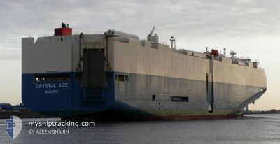
CRYSTAL ACE
Vehicles Carrier
Current Trip
| Time Travelled | 3 days |
|---|---|
| Remaining Time | --- |
| Distance Travelled | 1423.77 nm |
| Remaining Distance | --- |
| AVG Speed | 14.4 Knots |
| MAX Speed | 20.1 Knots |
| AVG Wind | 10.6 knots |
| MAX Wind | 31.6 knots |
| MIN Temp | 10.4°C / 50.72°F |
| MAX Temp | 20.7°C / 69.26°F |
| Draught | 8.6 m |
| Position Received | 2 d ago |
Current Position
| Longitude | -54.72059° |
|---|---|
| Latitude | -35.06634° |
| Status | Under way using engine |
| Speed | 18.3 Knots |
| Course | 90.5° |
| Area | South Atlantic Ocean |
| Station | T-AIS |
| Position Received | 2 d ago |
Info
Information
The current position of CRYSTAL ACE is in South Atlantic Ocean with coordinates -35.06634° / -54.72059° as reported on 2024-06-02 14:03 by AIS to our vessel tracker app. The vessel's current speed is 18.3 Knots and is heading at the port of EAST LONDON. The estimated time of arrival as calculated by MyShipTracking vessel tracking app is 2024-06-12 16:00 LT
The vessel CRYSTAL ACE (IMO: 9539224, MMSI: 538004619) is a Vehicles Carrier that was built in 2012 ( 12 years old ). It's sailing under the flag of [MH] Marshall Is.
In this page you can find informations about the vessels current position, last detected port calls, and current voyage information. If the vessels is not in coverage by AIS you will find the latest position.
The current position of CRYSTAL ACE is detected by our AIS receivers and we are not responsible for the reliability of the data. The last position was recorded while the vessel was in Coverage by the Ais receivers of our vessel tracking app.
The current draught of CRYSTAL ACE as reported by AIS is 8.6 meters
Weather
| Temperature | 19.4°C / 66.92°F |
|---|---|
| Wind Speed | 18 knots |
| Direction | 279° W |
| Pressure | 1019.6 hPa |
| Humidity | 66.4 % |
| Cloud Coverage | 37 % |
Featured Company
Last Port Calls
| Port | Arrival | Departure | Time In Port |
|---|---|---|---|
| 2024-06-01 07:04 | 2024-06-01 16:43 | 9 h | |
| 2024-05-28 10:04 | 2024-05-29 05:29 | 19 h | |
| 2024-05-25 10:52 | 2024-05-25 23:35 | 12 h | |
| 2024-05-15 04:49 | 2024-05-15 18:06 | 13 h | |
| 2024-05-10 07:26 | 2024-05-11 18:56 | 1 d | |
| 2024-05-06 20:46 | 2024-05-07 13:42 | 16 h | |
| 2024-05-03 20:10 | 2024-05-04 18:24 | 22 h | |
| 2024-05-02 02:56 | 2024-05-02 17:03 | 14 h | |
| 2024-04-24 10:10 | 2024-04-26 04:18 | 1 d | |
| 2024-04-22 06:06 | 2024-04-22 14:39 | 8 h |
Last Trips
| Origin | Departure | Destination | Arrival | Distance | |
|---|---|---|---|---|---|
| 2024-05-29 05:29 | 2024-06-01 07:04 | 1052.11 nm | |||
| 2024-05-25 23:35 | 2024-05-28 10:04 | 534.82 nm | |||
| 2024-05-15 18:06 | 2024-05-25 10:52 | 3899.31 nm | |||
| 2024-05-11 18:56 | 2024-05-15 04:49 | 1433.70 nm | |||
| 2024-05-07 13:42 | 2024-05-10 07:26 | 305.01 nm | |||
| 2024-05-04 18:24 | 2024-05-06 20:46 | 636.59 nm | |||
| 2024-05-02 17:03 | 2024-05-03 20:10 | 280.12 nm | |||
| 2024-04-26 04:18 | 2024-05-02 02:56 | 1768.70 nm | |||
| 2024-04-22 14:39 | 2024-04-24 10:10 | 475.91 nm | |||
| 2024-04-01 01:02 | 2024-04-22 06:06 | 8606.16 nm |
Events
| Time | Event | Details | Position / Dest | Info |
|---|---|---|---|---|
| 2024-06-02 14:10 | Status Changed | Default Under way using engine |
-35.06643 / -54.68030
ZAELS
|
Speed: 18.3 kn Course: 90.5° |
| 2024-06-02 14:03 | OUT of Coverage |
-35.06634 / -54.72059
South Atlantic Ocean
ZAELS
|
Speed: 18.3 kn Course: 90.5° |
|
| 2024-06-02 13:07 | Change Sea Area | Uruguayan part of the South Atlantic Ocean Uruguayan part of the Rio de La Plata |
-35.05009 / -55.06932
South Atlantic Ocean
ZAELS
|
Speed: 18.4 kn Course: 92.4° |
| 2024-06-02 11:40 | Status Changed | Under way using engine Default |
-35.06405 / -55.58119
ZAELS
|
Speed: 15.9 kn Course: 87° |
| 2024-06-02 11:38 | Status Changed | Default Under way using engine |
-35.06470 / -55.59566
ZAELS
|
Speed: 15.9 kn Course: 87.2° |
| 2024-06-02 10:02 | Status Changed | Under way using engine Default |
-35.09062 / -56.02504
ZAELS
|
Speed: 7.8 kn Course: 67° |
| 2024-06-02 09:43 | Status Changed | Default Under way using engine |
-35.11130 / -56.08266
ZAELS
|
Speed: 14 kn Course: 66.6° |
| 2024-06-02 09:36 | Status Changed | Under way using engine Default |
-35.12109 / -56.11129
ZAELS
|
Speed: 14.1 kn Course: 67° |
| 2024-06-02 09:31 | IN Coverage |
-35.12109 / -56.11129
Rio de La Plata
ZAELS
|
Speed: 14 kn Course: 66.6° |
|
| 2024-06-02 07:42 | OUT of Coverage |
-35.16860 / -56.63157
Rio de La Plata
ZAELS
|
Speed: 13.7 kn Course: 89.3° |