
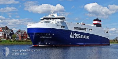
CITY OF HAMBURG
Ro-Ro Cargo
Current Trip
VIANA DO CASTEO
| Time Travelled | 3 days |
|---|---|
| Remaining Time | --- |
| Distance Travelled | 1236.72 nm |
| Remaining Distance | --- |
| AVG Speed | 13.5 Knots |
| MAX Speed | 16.6 Knots |
| AVG Wind | 8 knots |
| MAX Wind | 18.7 knots |
| MIN Temp | 13.5°C / 56.3°F |
| MAX Temp | 17.5°C / 63.5°F |
| Draught | 4.6 m |
| Position Received | 1 m ago |
Current Position
| Longitude | --- |
|---|---|
| Latitude | --- |
| Status | Under way using engine |
| Speed | 12.7 Knots |
| Course | 348° |
| Area | North Atlantic Ocean |
| Station | T-AIS |
| Position Received | 1 m ago |
Info
Information
The current position of CITY OF HAMBURG is in North Atlantic Ocean with coordinates 37.67345° / -9.54406° as reported on 2024-12-15 13:24 by AIS to our vessel tracker app. The vessel's current speed is 12.7 Knots
The vessel CITY OF HAMBURG (IMO: 9383558, MMSI: 228020700) is a Ro-Ro Cargo that was built in 2008 ( 16 years old ). It's sailing under the flag of [FR] France.
In this page you can find informations about the vessels current position, last detected port calls, and current voyage information. If the vessels is not in coverage by AIS you will find the latest position.
The current position of CITY OF HAMBURG is detected by our AIS receivers and we are not responsible for the reliability of the data. The last position was recorded while the vessel was in Coverage by the Ais receivers of our vessel tracking app.
The current draught of CITY OF HAMBURG as reported by AIS is 4.6 meters
Weather
| Temperature | 15°C / 59°F |
|---|---|
| Wind Speed | 16 knots |
| Direction | 72° ENE |
| Pressure | 1032.5 hPa |
| Humidity | 59.1 % |
| Cloud Coverage | 100 % |
Featured Company
Last Port Calls
| Port | Arrival | Departure | Time In Port |
|---|---|---|---|
| 2024-12-11 19:33 | 2024-12-11 22:17 | 2 h | |
| 2024-12-10 18:35 | 2024-12-11 00:24 | 5 h | |
| 2024-12-03 17:31 | 2024-12-04 20:25 | 1 d | |
| 2024-11-25 07:15 | 2024-11-29 13:26 | 4 d | |
| 2024-11-08 12:10 | 2024-11-09 16:54 | 1 d | |
| 2024-10-22 08:40 | 2024-10-25 20:13 | 3 d | |
| 2024-10-16 11:48 | 2024-10-17 06:02 | 18 h | |
| 2024-10-01 15:55 |
Last Trips
| Origin | Departure | Destination | Arrival | Distance | |
|---|---|---|---|---|---|
| 2024-12-11 00:24 | 2024-12-11 19:33 | 305.53 nm | |||
| 2024-12-04 20:25 | 2024-12-10 18:35 | 1834.18 nm | |||
| 2024-11-29 13:26 | 2024-12-03 17:31 | 49.56 nm | |||
| 2024-11-09 16:54 | 2024-11-25 07:15 | 4848.24 nm | |||
| 2024-10-25 20:13 | 2024-11-08 12:10 | 4927.19 nm | |||
| 2024-10-17 06:02 | 2024-10-22 08:40 | 51.65 nm | |||
| 2024-10-01 15:55 | 2024-10-16 11:48 | 4849.85 nm |
Events
| Time | Event | Details | Position / Dest | Info |
|---|---|---|---|---|
| 2024-12-15 09:13 | Status Changed | Under way using engine Default |
36.85619 / -9.28759
VIANA DO CASTEO
|
Speed: 12.2 kn Course: 315° |
| 2024-12-15 09:11 | Status Changed | Default Under way using engine |
36.85007 / -9.28014
VIANA DO CASTEO
|
Speed: 12.1 kn Course: 315.9° |
| 2024-12-15 08:48 | Status Changed | Under way using engine Default |
36.79589 / -9.21376
VIANA DO CASTEO
|
Speed: 11.8 kn Course: 314° |
| 2024-12-15 08:47 | Status Changed | Default Under way using engine |
36.79319 / -9.21035
VIANA DO CASTEO
|
Speed: 11.8 kn Course: 314° |
| 2024-12-15 08:02 | Status Changed | Under way using engine Default |
36.71510 / -9.05024
VIANA DO CASTEO
|
Speed: 12.4 kn Course: 290° |
| 2024-12-15 07:59 | Status Changed | Default Under way using engine |
36.71128 / -9.03776
VIANA DO CASTEO
|
Speed: 12.5 kn Course: 290.1° |
| 2024-12-15 04:50 | Status Changed | Under way using engine Default |
36.49762 / -8.23376
VIANA DO CASTEO
|
Speed: 13.3 kn Course: 288° |
| 2024-12-15 04:15 | Status Changed | Default Under way using engine |
36.45692 / -8.08216
VIANA DO CASTEO
|
Speed: 13.3 kn Course: 287.9° |
| 2024-12-15 04:08 | Status Changed | Under way using engine Default |
36.44889 / -8.05201
VIANA DO CASTEO
|
Speed: 13.3 kn Course: 288° |
| 2024-12-15 04:07 | Status Changed | Default Under way using engine |
36.44777 / -8.04775
VIANA DO CASTEO
|
Speed: 13.3 kn Course: 288° |