
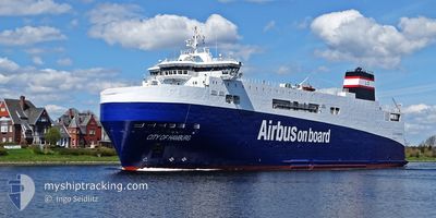
CITY OF HAMBURG
Ro-Ro Cargo
Current Trip
| Trip Time | 14 days |
|---|---|
| Trip Distance | 4801.33 nm |
| AVG Speed | 13.2 Knots |
| MAX Speed | 19 Knots |
| Dybgang | 4.8 m |
| AVG Wind | 18.2 knots |
| MAX Wind | 30.8 knots |
| MIN Temp | 10°C / 50°F |
| MAX Temp | 23.8°C / 74.84°F |
| Position Modtaget | 4 m siden |
Current Position
| Longitude | -2.16693° |
|---|---|
| Latitude | 47.28985° |
| Status | Moored |
| Fart | |
| Kurs | 231° |
| Område | Bay of Biscay |
| Station | T-AIS |
| Position Modtaget | 4 m siden |
Info
Information
The current position of CITY OF HAMBURG is in Bay of Biscay with coordinates 47.28985° / -2.16693° as reported on 2024-04-19 11:43 by AIS to our vessel tracker app. The vessel's current speed is 0 Knots and is currently inside the port of MONTOIR.
The vessel CITY OF HAMBURG (IMO: 9383558, MMSI: 228020700) is a Ro-Ro Cargo that was built in 2008 ( 16 år gamle ). It's sailing under the flag of [FR] France.
In this page you can find informations about the vessels current position, last detected port calls, and current voyage information. If the vessels is not in coverage by AIS you will find the latest position.
The current position of CITY OF HAMBURG is detected by our AIS receivers and we are not responsible for the reliability of the data. The last position was recorded while the vessel was in Coverage by the Ais receivers of our vessel tracking app.
The current draught of CITY OF HAMBURG as reported by AIS is 4.8 meters
Weather
| Temperature | 12.1°C / 53.78°F |
|---|---|
| Wind Speed | 10 knots |
| Direction | 286° WNW |
| Pressure | 1023.2 hPa |
| Humidity | 60.8 % |
| Cloud Coverage | --- |
Featured Company
Last Port Calls
| Port | Arrival | Departure | Time In Port |
|---|---|---|---|
| 2024-04-18 14:15 | |||
| 2024-04-02 17:11 | 2024-04-03 22:51 | 1 d | |
| 2024-03-18 08:13 | 2024-03-19 19:20 | 1 d | |
| 2024-03-02 18:07 | 2024-03-03 20:44 | 1 d | |
| 2024-02-13 14:11 | 2024-02-17 11:20 | 3 d | |
| 2024-02-11 18:34 | 2024-02-12 06:48 | 12 h |
Most Visited Ports (Last year)
| Port | Arrivals | |
|---|---|---|
| 13 | ||
| 10 | ||
| 3 | ||
| 2 |
Last Trips
| Origin | Departure | Destination | Arrival | Distance | |
|---|---|---|---|---|---|
| 2024-04-03 17:51 | 2024-04-18 16:15 | 4801.33 nm | |||
| 2024-03-19 20:20 | 2024-04-02 12:11 | 4850.92 nm | |||
| 2024-03-03 14:44 | 2024-03-18 09:13 | 4616.21 nm | |||
| 2024-02-17 12:20 | 2024-03-02 12:07 | 4842.81 nm | |||
| 2024-02-12 06:48 | 2024-02-13 15:11 | 445.40 nm | |||
| 2024-01-26 17:59 | 2024-02-11 18:34 | 4878.74 nm |
Events
| Tid | Hændelsen | Detaljer | Position / Dest | Info |
|---|---|---|---|---|
| 2024-04-18 16:43 | Status er ændret | Moored Default |
47.28989 / -2.16689
[FR] MONTOIR
|
Fart: Kurs: 231° |
| 2024-04-18 16:40 | Status er ændret | Default Moored |
47.28989 / -2.16689
[FR] MONTOIR
|
Fart: Kurs: 231° |
| 2024-04-18 15:37 | Status er ændret | Moored Default |
47.28988 / -2.16691
[FR] MONTOIR
|
Fart: Kurs: 231° |
| 2024-04-18 15:34 | Status er ændret | Default Moored |
47.28988 / -2.16693
[FR] MONTOIR
|
Fart: Kurs: 231° |
| 2024-04-18 14:53 | Status er ændret | Moored Under way using engine |
47.28987 / -2.16692
[FR] MONTOIR
|
Fart: Kurs: 230° |
| 2024-04-18 14:15 | Skibe i havn |
|
47.28927 / -2.16639
[FR] MONTOIR
|
Fart: 0.5 kn Kurs: 212° |
| 2024-04-18 14:12 | STOP Sejllads | 0.97 nm, South West of MONTOIR |
47.28876 / -2.16648
MONTOIR
|
Fart: 0.2 kn Kurs: 217° |
| 2024-04-18 09:40 | Status er ændret | Under way using engine Default |
46.79474 / -3.40803
MONTOIR
|
Fart: 14.8 kn Kurs: 70° |
| 2024-04-18 09:03 | Status er ændret | Default Under way using engine |
46.74372 / -3.61370
MONTOIR
|
Fart: 14.4 kn Kurs: 70.6° |
| 2024-04-18 08:23 | Fundet i havområde | French part of the Bay of Biscay |
46.68556 / -3.83405
Bay of Biscay
MONTOIR
|
Fart: 14.2 kn Kurs: 69.3° |