
RIVERO
Wing in ground
Current Trip
| Trip Time | 2 days |
|---|---|
| Trip Distance | 273.70 nm |
| AVG Speed | 6.2 Knots |
| MAX Speed | 10.9 Knots |
| Draught | 0 m |
| AVG Wind | 9 knots |
| MAX Wind | 14.3 knots |
| MIN Temp | -7.3°C / 18.86°F |
| MAX Temp | 4.3°C / 39.74°F |
| Position Received | 7 h, 1 m ago |
Current Position
| Longitude | --- |
|---|---|
| Latitude | --- |
| Status | Under way using engine |
| Speed | 5 Knots |
| Course | 353.1° |
| Area | North Sea |
| Station | T-AIS |
| Position Received | 7 h, 1 m ago |
Info
Information
The current position of RIVERO is in North Sea with coordinates 50.07684° / 8.52242° as reported on 2026-01-05 15:21 by AIS to our vessel tracker app. The vessel's current speed is 5 Knots and is currently inside the port of HOCHST.
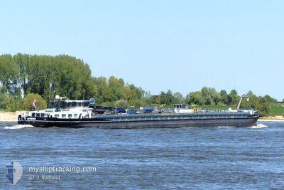
The vessel RIVERO (MMSI: 244670274) is a Wing in ground It's sailing under the flag of [NL] Netherlands.
In this page you can find informations about the vessels current position, last detected port calls, and current voyage information. If the vessels is not in coverage by AIS you will find the latest position.
The current position of RIVERO is detected by our AIS receivers and we are not responsible for the reliability of the data. The last position was recorded while the vessel was in Coverage by the Ais receivers of our vessel tracking app.
Weather
| Temperature | -3.2°C / 26.24°F |
|---|---|
| Wind Speed | 5 knots |
| Direction | 198° SSW |
| Pressure | 1015 hPa |
| Humidity | 94.6 % |
| Cloud Coverage | 81 % |
Featured Company
Last Port Calls
| Port | Arrival | Departure | Time In Port |
|---|---|---|---|
| 2026-01-05 16:25 | |||
| 2026-01-03 07:08 | 2026-01-03 13:25 | 6 h | |
| 2026-01-02 16:57 | 2026-01-03 06:42 | 13 h | |
| 2025-12-27 21:40 | 2025-12-28 06:39 | 8 h | |
| 2025-12-27 16:09 | 2025-12-27 18:46 | 2 h | |
| 2025-12-25 15:08 | 2025-12-27 14:48 | 1 d | |
| 2025-12-25 08:26 | 2025-12-25 10:22 | 1 h | |
| 2025-12-21 20:37 | 2025-12-23 11:59 | 1 d | |
| 2025-12-19 20:11 | 2025-12-19 20:44 | 32 m | |
| 2025-12-18 14:34 | 2025-12-19 18:37 | 1 d |
Last Trips
| Origin | Departure | Destination | Arrival | Distance | |
|---|---|---|---|---|---|
| 2026-01-03 13:25 | 2026-01-05 16:25 | 273.70 nm | |||
| 2026-01-03 06:42 | 2026-01-03 07:08 | 3.22 nm | |||
| 2025-12-28 06:39 | 2026-01-02 16:57 | 194.38 nm | |||
| 2025-12-27 18:46 | 2025-12-27 21:40 | 30.45 nm | |||
| 2025-12-27 14:48 | 2025-12-27 16:09 | 9.38 nm | |||
| 2025-12-25 10:22 | 2025-12-25 15:08 | 34.08 nm | |||
| 2025-12-23 11:59 | 2025-12-25 08:26 | 85.34 nm | |||
| 2025-12-19 20:44 | 2025-12-21 20:37 | 253.19 nm | |||
| 2025-12-19 18:37 | 2025-12-19 20:11 | 9.74 nm | |||
| 2025-12-18 12:13 | 2025-12-18 14:34 | 9.61 nm |
Events
| Time | Event | Details | Position / Dest | Info |
|---|---|---|---|---|
| 2026-01-05 15:25 | PORT ARRIVAL |
|
50.08167 / 8.52167
[DE] HOCHST
|
Speed: 5 kn Course: 353.1° |
| 2026-01-05 15:20 | OUT of Coverage |
50.07486 / 8.52324
North Sea
CARGILL FRANKFURT
|
Speed: 5.9 kn Course: 341.7° |
|
| 2026-01-05 14:52 | START Moving | 3.52 nm, South West of HOCHST |
50.04239 / 8.48268
CARGILL FRANKFURT
|
Speed: 5.9 kn Course: 51.1° |
| 2026-01-05 14:47 | Status Changed | Under way using engine Default |
50.03834 / 8.47649
CARGILL FRANKFURT
|
Speed: Course: -1° |
| 2026-01-05 14:43 | Status Changed | Default Under way using engine |
50.03667 / 8.47500
CARGILL FRANKFURT
|
Speed: 1.4 kn Course: 511° |
| 2026-01-05 14:43 | STOP Moving | 3.97 nm, South West of HOCHST |
50.03667 / 8.47500
CARGILL FRANKFURT
|
Speed: Course: -1° |
| 2026-01-05 09:22 | IN Coverage |
49.97248 / 7.91947
North Sea
CARGILL FRANKFURT
|
Speed: 5.2 kn Course: 104.7° |
|
| 2026-01-04 22:19 | Status Changed | Default Under way using engine |
50.50500 / 7.30833
CARGILL FRANKFURT
|
Speed: 4.4 kn Course: 154.3° |
| 2026-01-04 22:09 | OUT of Coverage |
50.51735 / 7.29798
North Sea
CARGILL FRANKFURT
|
Speed: 4.4 kn Course: 154.3° |
|
| 2026-01-04 20:11 | Status Changed | Under way using engine Default |
50.66403 / 7.19630
CARGILL FRANKFURT
|
Speed: 5.6 kn Course: 152° |