
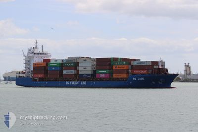
BG JADE
Cargo A
Current Trip
| Time Travelled | 15 h, 9 mins |
|---|---|
| Remaining Time | 4 h, 39 mins |
| Distance Travelled | 224.61 nm |
| Remaining Distance | 52.95 nm |
| AVG Speed | 13.8 Knots |
| MAX Speed | 18.3 Knots |
| AVG Wind | 19.7 knots |
| MAX Wind | 38 knots |
| MIN Temp | 7.5°C / 45.5°F |
| MAX Temp | 10.7°C / 51.26°F |
| Draught | 7.6 m |
| Position Received | 2 m ago |
Current Position
| Longitude | --- |
|---|---|
| Latitude | --- |
| Status | Under way using engine |
| Speed | 10.1 Knots |
| Course | 182° |
| Area | English Channel |
| Station | T-AIS |
| Position Received | 2 m ago |
Info
Information
The current position of BG JADE is in English Channel with coordinates 50.23375° / -0.43582° as reported on 2025-12-05 19:24 by AIS to our vessel tracker app. The vessel's current speed is 10.1 Knots and is heading at the port of SOUTHAMPTON. The estimated time of arrival as calculated by MyShipTracking vessel tracking app is 2025-12-06 00:06 LT
The vessel BG JADE (IMO: 9803687, MMSI: 212752000) is a Cargo A It's sailing under the flag of [CY] Cyprus.
In this page you can find informations about the vessels current position, last detected port calls, and current voyage information. If the vessels is not in coverage by AIS you will find the latest position.
The current position of BG JADE is detected by our AIS receivers and we are not responsible for the reliability of the data. The last position was recorded while the vessel was in Coverage by the Ais receivers of our vessel tracking app.
The current draught of BG JADE as reported by AIS is 7.6 meters
Weather
| Temperature | 10.5°C / 50.9°F |
|---|---|
| Wind Speed | 37 knots |
| Direction | 188° S |
| Pressure | 998.1 hPa |
| Humidity | 88 % |
| Cloud Coverage | 100 % |
Featured Company
Last Port Calls
| Port | Arrival | Departure | Time In Port |
|---|---|---|---|
| 2025-12-04 14:37 | 2025-12-05 05:18 | 14 h | |
| 2025-12-02 04:15 | 2025-12-04 14:34 | 2 d | |
| 2025-12-01 11:35 | 2025-12-02 02:42 | 15 h | |
| 2025-11-27 11:08 | 2025-11-29 09:01 | 1 d | |
| 2025-11-25 13:01 | 2025-11-26 02:43 | 13 h | |
| 2025-11-23 08:49 | 2025-11-23 18:54 | 10 h | |
| 2025-11-21 14:51 | 2025-11-23 07:31 | 1 d | |
| 2025-11-20 19:06 | 2025-11-21 13:18 | 18 h | |
| 2025-11-18 00:58 | 2025-11-19 14:11 | 1 d | |
| 2025-11-15 23:47 | 2025-11-16 18:27 | 18 h |
Most Visited Ports (Last year)
| Port | Arrivals | |
|---|---|---|
| 80 | ||
| 35 | ||
| 24 | ||
| 13 | ||
| 11 | ||
| 11 |
Last Trips
| Origin | Departure | Destination | Arrival | Distance | |
|---|---|---|---|---|---|
| 2025-12-04 14:34 | 2025-12-04 14:37 | 0.38 nm | |||
| 2025-12-02 02:42 | 2025-12-02 04:15 | 15.50 nm | |||
| 2025-11-29 09:01 | 2025-12-01 11:35 | 747.51 nm | |||
| 2025-11-26 02:43 | 2025-11-27 11:08 | 111.50 nm | |||
| 2025-11-23 18:54 | 2025-11-25 13:01 | 628.74 nm | |||
| 2025-11-23 07:31 | 2025-11-23 08:49 | 15.34 nm | |||
| 2025-11-21 13:18 | 2025-11-21 14:51 | 16.23 nm | |||
| 2025-11-19 14:11 | 2025-11-20 19:06 | 393.81 nm | |||
| 2025-11-16 18:27 | 2025-11-18 00:58 | 398.22 nm | |||
| 2025-11-15 22:28 | 2025-11-15 23:47 | 13.91 nm |
Events
| Time | Event | Details | Position / Dest | Info |
|---|---|---|---|---|
| 2025-12-05 19:17 | Status Changed | Under way using engine Default |
50.25445 / -.43382
GBSOU
|
Speed: 10.1 kn Course: 185° |
| 2025-12-05 18:27 | Status Changed | Default Under way using engine |
50.39599 / -.41662
GBSOU
|
Speed: 10.6 kn Course: 183.1° |
| 2025-12-05 17:44 | Status Changed | Under way using engine Default |
50.52628 / -.40975
GBSOU
|
Speed: 10.8 kn Course: 199° |
| 2025-12-05 17:43 | Status Changed | Default Under way using engine |
50.52972 / -.40810
GBSOU
|
Speed: 11.9 kn Course: 225.2° |
| 2025-12-05 16:16 | Status Changed | Under way using engine Default |
50.56148 / .09953
GBSOU
|
Speed: 15.4 kn Course: 258° |
| 2025-12-05 16:01 | IN Coverage |
50.56123 / .09763
English Channel
GBSOU
|
Speed: 15.8 kn Course: 259.7° |
|
| 2025-12-05 12:57 | Status Changed | Default Under way using engine |
50.96845 / 1.26358
GBSOU
|
Speed: 13.2 kn Course: 228.9° |
| 2025-12-05 12:50 | OUT of Coverage |
50.98500 / 1.29440
English Channel
GBSOU
|
Speed: 13.2 kn Course: 228.9° |
|
| 2025-12-05 12:10 | Change Sea Area | United Kingdom part of the English Channel United Kingdom part of the North Sea |
51.06898 / 1.47483
English Channel
GBSOU
|
Speed: 12.8 kn Course: 237.9° |
| 2025-12-05 09:10 | Change Sea Area | United Kingdom part of the North Sea Belgian part of the North Sea |
51.62783 / 2.26867
North Sea
GBSOU
|
Speed: 17.9 kn Course: 221.3° |