
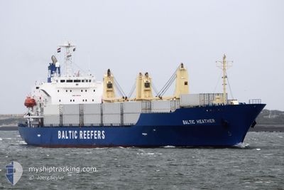
BALTIC HEATHER
Reefer
Current Trip
| Time Travelled | 12 h, 58 mins |
|---|---|
| Remaining Time | --- |
| Distance Travelled | 176.02 nm |
| Remaining Distance | 8.60 nm |
| AVG Speed | 15.6 Knots |
| MAX Speed | 18.6 Knots |
| AVG Wind | 9.6 knots |
| MAX Wind | 15.6 knots |
| MIN Temp | 1.8°C / 35.24°F |
| MAX Temp | 4.5°C / 40.1°F |
| Draught | 7 m |
| Position Received | 3 m ago |
Current Position
| Longitude | 24.59426° |
|---|---|
| Latitude | 59.48773° |
| Status | At anchor |
| Speed | 0.5 Knots |
| Course | 235° |
| Area | Gulf of Finland |
| Station | T-AIS |
| Position Received | 3 m ago |
Info
Information
The current position of BALTIC HEATHER is in Gulf of Finland with coordinates 59.48773° / 24.59426° as reported on 2024-04-26 09:10 by AIS to our vessel tracker app. The vessel's current speed is 0.5 Knots and is heading at the port of TALLINN OLD HARBOR. The estimated time of arrival as calculated by MyShipTracking vessel tracking app is 2024-04-26 09:00 LT
The vessel BALTIC HEATHER (IMO: 9181144, MMSI: 311000973) is a Reefer that was built in 1998 ( 26 years old ). It's sailing under the flag of [BS] Bahamas.
In this page you can find informations about the vessels current position, last detected port calls, and current voyage information. If the vessels is not in coverage by AIS you will find the latest position.
The current position of BALTIC HEATHER is detected by our AIS receivers and we are not responsible for the reliability of the data. The last position was recorded while the vessel was in Coverage by the Ais receivers of our vessel tracking app.
The current draught of BALTIC HEATHER as reported by AIS is 7 meters
Weather
| Temperature | 4.5°C / 40.1°F |
|---|---|
| Wind Speed | 7 knots |
| Direction | 227° SW |
| Pressure | 1010.3 hPa |
| Humidity | 80.4 % |
| Cloud Coverage | 100 % |
Featured Company
Last Port Calls
| Port | Arrival | Departure | Time In Port |
|---|---|---|---|
| 2024-04-19 02:40 | 2024-04-25 20:16 | 6 d | |
| 2024-04-10 17:53 | 2024-04-11 00:03 | 6 h | |
| 2024-03-25 19:10 | 2024-03-31 02:02 | 5 d | |
| 2024-03-18 08:55 | 2024-03-23 23:44 | 5 d | |
| 2024-03-13 06:33 | 2024-03-15 15:57 | 2 d | |
| 2024-02-28 16:54 | 2024-03-02 10:34 | 2 d | |
| 2024-02-14 13:44 | 2024-02-16 11:10 | 1 d | |
| 2024-02-07 20:02 | 2024-02-08 20:54 | 1 d |
Most Visited Ports (Last year)
| Port | Arrivals | |
|---|---|---|
| 5 | ||
| 3 | ||
| 2 | ||
| 2 | ||
| 1 | ||
| 1 |
Last Trips
| Origin | Departure | Destination | Arrival | Distance | |
|---|---|---|---|---|---|
| 2024-04-11 01:03 | 2024-04-19 05:40 | 3178.22 nm | |||
| 2024-03-31 04:02 | 2024-04-10 18:53 | 4435.17 nm | |||
| 2024-03-24 01:44 | 2024-03-25 21:10 | 814.62 nm | |||
| 2024-03-15 17:57 | 2024-03-18 10:55 | 666.24 nm | |||
| 2024-03-02 12:34 | 2024-03-13 08:33 | 2629.15 nm | |||
| 2024-02-16 12:10 | 2024-02-28 18:54 | 940.79 nm | |||
| 2024-02-08 21:54 | 2024-02-14 14:44 | 1088.09 nm | |||
| 2024-01-25 12:48 | 2024-02-07 21:02 | 5682.04 nm |
Events
| Time | Event | Details | Position / Dest | Info |
|---|---|---|---|---|
| 2024-04-26 09:01 | Status Changed | At anchor Under way using engine |
59.48714 / 24.59386
EE TLL
|
Speed: 1.3 kn Course: 185° |
| 2024-04-26 08:56 | STOP Moving | 2.7 nm, North West of VENE BALTI |
59.48712 / 24.59264
EE TLL
|
Speed: 0.3 kn Course: 175° |
| 2024-04-26 07:29 | Status Changed | Under way using engine Default |
59.65795 / 24.64681
EE TLL
|
Speed: 13.9 kn Course: 187° |
| 2024-04-26 07:28 | Status Changed | Default Under way using engine |
59.65955 / 24.64722
EE TLL
|
Speed: 13.7 kn Course: 182.5° |
| 2024-04-26 07:18 | Status Changed | Under way using engine Default |
59.69977 / 24.65262
EE TLL
|
Speed: 13.7 kn Course: 186° |
| 2024-04-26 07:16 | Status Changed | Default Under way using engine |
59.70552 / 24.65408
EE TLL
|
Speed: 13.7 kn Course: 186.9° |
| 2024-04-26 05:37 | Change Sea Area | Estonian part of the Gulf of Finland Finnish part of the Gulf of Finland |
59.87781 / 25.37405
Gulf of Finland
EE TLL
|
Speed: 17.2 kn Course: 263.8° |
| 2024-04-26 04:25 | Change Sea Area | Finnish part of the Gulf of Finland Estonian part of the Gulf of Finland |
59.95331 / 26.08485
Gulf of Finland
EE TLL
|
Speed: 18.6 kn Course: 251.5° |
| 2024-04-26 04:01 | Change Sea Area | Estonian part of the Gulf of Finland Russian part of the Gulf of Finland |
59.98924 / 26.32258
Gulf of Finland
EE TLL
|
Speed: 18 kn Course: 253.4° |
| 2024-04-26 00:20 | ETA Changed | 2024/04/26 09:00 2024/04/18 20:30 |
60.10261 / 28.34439
EE TLL
|
Speed: 17.7 kn Course: 312.9° |