
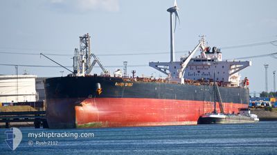
BAKER SPIRIT
Crude Oil Tanker
Current Trip
| Time Travelled | 20 days |
|---|---|
| Remaining Time | --- |
| Distance Travelled | 5001.95 nm |
| Remaining Distance | --- |
| AVG Speed | 10 Knots |
| MAX Speed | 16 Knots |
| AVG Wind | 14.2 knots |
| MAX Wind | 38 knots |
| MIN Temp | 7.2°C / 44.96°F |
| MAX Temp | 27.2°C / 80.96°F |
| Draught | 9.3 m |
| Position Received | 7 d ago |
Current Position
| Longitude | --- |
|---|---|
| Latitude | --- |
| Status | Under way using engine |
| Speed | 10.4 Knots |
| Course | 203.1° |
| Area | North Atlantic Ocean |
| Station | T-AIS |
| Position Received | 7 d ago |
Info
Information
The current position of BAKER SPIRIT is in North Atlantic Ocean with coordinates 10.09896° / -23.86336° as reported on 2025-12-30 07:21 by AIS to our vessel tracker app. The vessel's current speed is 10.4 Knots and is heading at the port of TERNEUZEN. The estimated time of arrival as calculated by MyShipTracking vessel tracking app is 2026-01-10 01:01 LT
The vessel BAKER SPIRIT (IMO: 9408073, MMSI: 311000334) is a Crude Oil Tanker that was built in 2009 ( 17 years old ). It's sailing under the flag of [BS] Bahamas.
In this page you can find informations about the vessels current position, last detected port calls, and current voyage information. If the vessels is not in coverage by AIS you will find the latest position.
The current position of BAKER SPIRIT is detected by our AIS receivers and we are not responsible for the reliability of the data. The last position was recorded while the vessel was in Coverage by the Ais receivers of our vessel tracking app.
The current draught of BAKER SPIRIT as reported by AIS is 9.3 meters
Weather
| Temperature | 26.3°C / 79.34°F |
|---|---|
| Wind Speed | 13 knots |
| Direction | 65° ENE |
| Pressure | 1015.8 hPa |
| Humidity | 67.4 % |
| Cloud Coverage | 100 % |
Featured Company
Last Port Calls
| Port | Arrival | Departure | Time In Port |
|---|---|---|---|
| 2025-12-15 09:34 | 2025-12-16 23:49 | 1 d | |
| 2025-12-06 11:41 | 2025-12-08 01:21 | 1 d | |
| 2025-11-28 09:14 | 2025-11-30 08:21 | 1 d |
Most Visited Ports (Last year)
| Port | Arrivals | |
|---|---|---|
| 2 | ||
| 2 | ||
| 2 | ||
| 2 | ||
| 1 | ||
| 1 |
Events
| Time | Event | Details | Position / Dest | Info |
|---|---|---|---|---|
| 2025-12-30 07:26 | Status Changed | Default Under way using engine |
10.08530 / -23.86972
FOR ORDERS
|
Speed: 10.4 kn Course: 203.1° |
| 2025-12-30 07:21 | OUT of Coverage |
10.09896 / -23.86336
North Atlantic Ocean
FOR ORDERS
|
Speed: 10.4 kn Course: 203.1° |
|
| 2025-12-30 07:08 | Status Changed | Under way using engine Default |
10.13332 / -23.84805
FOR ORDERS
|
Speed: 10.5 kn Course: 204° |
| 2025-12-30 06:26 | Status Changed | Default Under way using engine |
10.24662 / -23.79633
FOR ORDERS
|
Speed: 10.4 kn Course: 206.1° |
| 2025-12-30 05:51 | Status Changed | Under way using engine Default |
10.33863 / -23.75414
FOR ORDERS
|
Speed: 10.5 kn Course: 204° |
| 2025-12-30 05:47 | Status Changed | Default Under way using engine |
10.35081 / -23.74871
FOR ORDERS
|
Speed: 10.4 kn Course: 203.5° |
| 2025-12-30 05:14 | Status Changed | Under way using engine Default |
10.43741 / -23.70713
FOR ORDERS
|
Speed: 10.4 kn Course: 206° |
| 2025-12-30 05:02 | Status Changed | Default Under way using engine |
10.46880 / -23.69155
FOR ORDERS
|
Speed: 10.6 kn Course: 205.1° |
| 2025-12-30 04:44 | Status Changed | Under way using engine Default |
10.51776 / -23.66767
FOR ORDERS
|
Speed: 10.5 kn Course: 205° |
| 2025-12-30 04:23 | Status Changed | Default Under way using engine |
10.57475 / -23.64146
FOR ORDERS
|
Speed: 10.4 kn Course: 203.4° |