
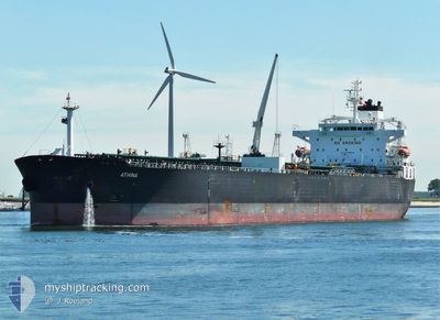
ATHINA
Crude Oil Tanker
Current Trip
| Time Travelled | 8 days |
|---|---|
| Remaining Time | 3 days |
| Distance Travelled | 1952.35 nm |
| Remaining Distance | 1087.74 nm |
| AVG Speed | 11.8 Knots |
| MAX Speed | 14.9 Knots |
| AVG Wind | 10.7 knots |
| MAX Wind | 17 knots |
| MIN Temp | 23.5°C / 74.3°F |
| MAX Temp | 28.5°C / 83.3°F |
| Draught | 8.2 m |
| Position Received | 3 d ago |
Current Position
| Longitude | --- |
|---|---|
| Latitude | --- |
| Status | Under way using engine |
| Speed | 12.5 Knots |
| Course | 312.4° |
| Area | Malacca Strait |
| Station | T-AIS |
| Position Received | 3 d ago |
Info
Information
The current position of ATHINA is in Malacca Strait with coordinates 1.97163° / 102.23371° as reported on 2026-01-01 11:21 by AIS to our vessel tracker app. The vessel's current speed is 12.5 Knots and is heading at the port of SINGAPORE. The estimated time of arrival as calculated by MyShipTracking vessel tracking app is 2026-01-08 02:19 LT
The vessel ATHINA (IMO: 9389564, MMSI: 636013375) is a Crude Oil Tanker that was built in 2008 ( 18 years old ). It's sailing under the flag of [LR] Liberia.
In this page you can find informations about the vessels current position, last detected port calls, and current voyage information. If the vessels is not in coverage by AIS you will find the latest position.
The current position of ATHINA is detected by our AIS receivers and we are not responsible for the reliability of the data. The last position was recorded while the vessel was in Coverage by the Ais receivers of our vessel tracking app.
The current draught of ATHINA as reported by AIS is 8.2 meters
Weather
| Temperature | 24.8°C / 76.64°F |
|---|---|
| Wind Speed | 6 knots |
| Direction | 23° NNE |
| Pressure | 1012.3 hPa |
| Humidity | 92.2 % |
| Cloud Coverage | 100 % |
Featured Company
Last Port Calls
| Port | Arrival | Departure | Time In Port |
|---|---|---|---|
| 2025-12-26 12:24 | 2025-12-27 16:32 | 1 d | |
| 2025-12-22 00:18 | 2025-12-23 18:10 | 1 d | |
| 2025-12-02 05:26 | 2025-12-03 21:58 | 1 d |
Last Trips
| Origin | Departure | Destination | Arrival | Distance | |
|---|---|---|---|---|---|
| 2025-12-23 18:10 | 2025-12-26 12:24 | 780.70 nm | |||
| 2025-12-03 21:58 | 2025-12-22 00:18 | 4639.89 nm | |||
| 2025-10-24 20:20 | 2025-12-02 05:26 | 4975.32 nm |
Events
| Time | Event | Details | Position / Dest | Info |
|---|---|---|---|---|
| 2026-01-01 11:29 | Status Changed | Default Under way using engine |
1.99004 / 102.21257
SG SIN
|
Speed: 12.5 kn Course: 312.4° |
| 2026-01-01 11:21 | Change Sea Area | Malaysian part of the Malacca Strait Singaporean part of the Singapore Strait |
1.97163 / 102.23371
Malacca Strait
|
Speed: 12.5 kn Course: 312.4° |
| 2026-01-01 11:21 | Status Changed | Under way using engine Default |
1.97163 / 102.23371
SG SIN
|
Speed: 12.5 kn Course: 312° |
| 2026-01-01 11:21 | OUT of Coverage |
1.97163 / 102.23371
Malacca Strait
|
Speed: 12.5 kn Course: 312.4° |
|
| 2026-01-01 11:05 | IN Coverage |
1.97163 / 102.23371
Malacca Strait
|
Speed: 12.5 kn Course: 312.4° |
|
| 2026-01-01 03:17 | Status Changed | Default Under way using engine |
1.15851 / 103.76838
SG SIN
|
Speed: 9.7 kn Course: 243.1° |
| 2026-01-01 03:11 | OUT of Coverage |
1.16632 / 103.78156
Singapore Strait
|
Speed: 9.7 kn Course: 243.1° |
|
| 2026-01-01 03:08 | Status Changed | Under way using engine Default |
1.17035 / 103.78916
SG SIN
|
Speed: 9.6 kn Course: 244° |
| 2026-01-01 02:55 | Status Changed | Default Under way using engine |
1.18543 / 103.82123
SG SIN
|
Speed: 10.7 kn Course: 247.8° |
| 2026-01-01 02:51 | Status Changed | Under way using engine Default |
1.19012 / 103.83266
SG SIN
|
Speed: 10.6 kn Course: 246° |