
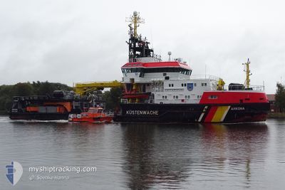
ARKONA
Pollution Control Vessel
Current Trip
COASTGUARD PATROL
| Time Travelled | 4 days |
|---|---|
| Remaining Time | --- |
| Distance Travelled | 271.67 nm |
| Remaining Distance | --- |
| AVG Speed | 6.1 Knots |
| MAX Speed | 10.5 Knots |
| AVG Wind | 14.4 knots |
| MAX Wind | 28 knots |
| MIN Temp | 1.9°C / 35.42°F |
| MAX Temp | 8.9°C / 48.02°F |
| Draught | 4 m |
| Position Received | 1 m ago |
Current Position
| Longitude | --- |
|---|---|
| Latitude | --- |
| Status | Under way using engine |
| Speed | 5.4 Knots |
| Course | 266.3° |
| Area | Baltic Sea |
| Station | T-AIS |
| Position Received | 1 m ago |
Info
Information
The current position of ARKONA is in Baltic Sea with coordinates 54.56443° / 12.58048° as reported on 2025-03-05 13:11 by AIS to our vessel tracker app. The vessel's current speed is 5.4 Knots
The vessel ARKONA (IMO: 9285811, MMSI: 211130000) is a Pollution Control Vessel that was built in 2004 ( 21 years old ). It's sailing under the flag of [DE] Germany.
In this page you can find informations about the vessels current position, last detected port calls, and current voyage information. If the vessels is not in coverage by AIS you will find the latest position.
The current position of ARKONA is detected by our AIS receivers and we are not responsible for the reliability of the data. The last position was recorded while the vessel was in Coverage by the Ais receivers of our vessel tracking app.
The current draught of ARKONA as reported by AIS is 4 meters
Weather
| Temperature | 6.5°C / 43.7°F |
|---|---|
| Wind Speed | 25 knots |
| Direction | 243° WSW |
| Pressure | 1018.1 hPa |
| Humidity | 70.6 % |
| Cloud Coverage | 100 % |
Featured Company
Last Port Calls
| Port | Arrival | Departure | Time In Port |
|---|---|---|---|
| 2025-02-25 07:20 | 2025-02-28 15:33 | 3 d | |
| 2025-02-19 07:55 | 2025-02-19 16:43 | 8 h | |
| 2025-02-13 07:08 | 2025-02-13 11:21 | 4 h | |
| 2025-01-29 07:35 | 2025-01-29 11:20 | 3 h | |
| 2025-01-28 13:34 | 2025-01-28 14:05 | 30 m | |
| 2025-01-20 07:46 | 2025-01-20 13:05 | 5 h | |
| 2025-01-17 08:18 | 2025-01-17 10:06 | 1 h | |
| 2025-01-09 12:34 | 2025-01-09 17:15 | 4 h | |
| 2025-01-04 12:41 | 2025-01-04 13:29 | 47 m | |
| 2025-01-03 07:36 | 2025-01-03 11:03 | 3 h |
Last Trips
| Origin | Departure | Destination | Arrival | Distance | |
|---|---|---|---|---|---|
| 2025-02-19 16:43 | 2025-02-25 07:20 | 315.11 nm | |||
| 2025-02-13 11:21 | 2025-02-19 07:55 | 316.14 nm | |||
| 2025-01-29 11:20 | 2025-02-13 07:08 | 505.18 nm | |||
| 2025-01-28 14:05 | 2025-01-29 07:35 | 27.72 nm | |||
| 2025-01-20 13:05 | 2025-01-28 13:34 | 145.94 nm | |||
| 2025-01-17 10:06 | 2025-01-20 07:46 | 81.71 nm | |||
| 2025-01-09 17:15 | 2025-01-17 08:18 | 288.28 nm | |||
| 2025-01-04 13:29 | 2025-01-09 12:34 | 324.30 nm | |||
| 2025-01-03 11:03 | 2025-01-04 12:41 | 52.10 nm | |||
| 2024-12-28 11:11 | 2025-01-03 07:36 | 467.57 nm |
Events
| Time | Event | Details | Position / Dest | Info |
|---|---|---|---|---|
| 2025-03-05 05:41 | START Moving | 9.69 nm, North West of SASSNITZ |
54.62059 / 13.43852
COASTGUARD PATROL
|
Speed: 3.1 kn Course: 348° |
| 2025-03-04 22:11 | STOP Moving | 7.74 nm, North West of SASSNITZ |
54.61895 / 13.52188
COASTGUARD PATROL
|
Speed: 0.2 kn Course: 245° |
| 2025-03-04 17:34 | Draught Changed | 4 4.1 |
54.51525 / 13.71076
COASTGUARD PATROL
|
Speed: 6.3 kn Course: 64.1° |
| 2025-03-04 17:34 | Destination Changed | COASTGUARD PATROL DE SAS |
54.51525 / 13.71076
COASTGUARD PATROL
|
Speed: 6.3 kn Course: 64.1° |
| 2025-03-04 17:34 | ETA Changed | 2025/03/06 07:00 2025/03/04 10:15 |
54.51525 / 13.71076
COASTGUARD PATROL
|
Speed: 6.3 kn Course: 64.1° |
| 2025-03-04 17:09 | IN Coverage |
54.49726 / 13.64265
Baltic Sea
|
Speed: 6.4 kn Course: 65.8° |
|
| 2025-03-04 10:04 | OUT of Coverage |
54.50444 / 13.63523
Baltic Sea
DE SAS
|
Speed: 6.8 kn Course: 13.5° |
|
| 2025-03-04 08:36 | IN Coverage |
54.43252 / 13.76906
Baltic Sea
DE SAS
|
Speed: 1.1 kn Course: 309.8° |
|
| 2025-03-04 06:16 | OUT of Coverage |
54.42917 / 13.70270
Baltic Sea
DE SAS
|
Speed: 0.8 kn Course: 89° |
|
| 2025-03-04 05:28 | ETA Changed | 2025/03/04 10:15 2025/03/04 11:00 |
54.42946 / 13.68046
DE SAS
|
Speed: 1 kn Course: 157° |