
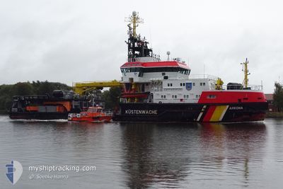
ARKONA
Pollution Control Vessel
Current Trip
COASTGUARD PATROL
| Time Travelled | 7 h, 7 mins |
|---|---|
| Remaining Time | --- |
| Distance Travelled | 56.43 nm |
| Remaining Distance | --- |
| AVG Speed | 8.3 Noeuds |
| MAX Speed | 10 Noeuds |
| AVG Wind | 5.8 knots |
| MAX Wind | 9.7 knots |
| MIN Temp | 3.3°C / 37.94°F |
| MAX Temp | 5°C / 41°F |
| Tirant d eau | 4.2 m |
| Position reçue | 1 m depuis |
Current Position
| Longitude | --- |
|---|---|
| Latitude | --- |
| Etat | Under way using engine |
| Vitesse | 7.3 Noeuds |
| Parcours | 117.5° |
| Zone | Baltic Sea |
| Station | T-AIS |
| Position reçue | 1 m depuis |
Info
Information
The current position of ARKONA is in Baltic Sea with coordinates 54.45212° / 11.63466° as reported on 2025-12-05 19:54 by AIS to our vessel tracker app. The vessel's current speed is 7.3 Noeuds
The vessel ARKONA (IMO: 9285811, MMSI: 211130000) is a Pollution Control Vessel that was built in 2004 ( 21 Age ). It's sailing under the flag of [DE] Germany.
In this page you can find informations about the vessels current position, last detected port calls, and current voyage information. If the vessels is not in coverage by AIS you will find the latest position.
The current position of ARKONA is detected by our AIS receivers and we are not responsible for the reliability of the data. The last position was recorded while the vessel was in Coverage by the Ais receivers of our vessel tracking app.
The current draught of ARKONA as reported by AIS is 4.2 meters
Weather
| Temperature | 5.1°C / 41.18°F |
|---|---|
| Wind Speed | 8 knots |
| Direction | 223° SW |
| Pressure | 1011.5 hPa |
| Humidity | 83.6 % |
| Cloud Coverage | 78 % |
Featured Company
Last Port Calls
| Port | Arrival | Departure | Time In Port |
|---|---|---|---|
| 2025-12-05 12:48 | 2025-12-05 13:48 | 1 h | |
| 2025-12-05 09:48 | 2025-12-05 11:10 | 1 h | |
| 2025-12-04 09:04 | 2025-12-04 12:50 | 3 h | |
| 2025-12-03 16:51 | 2025-12-03 17:27 | 36 m | |
| 2025-12-01 07:34 | 2025-12-01 14:04 | 6 h | |
| 2025-11-29 07:08 | 2025-11-29 09:54 | 2 h | |
| 2025-11-27 08:32 | 2025-11-27 11:28 | 2 h | |
| 2025-11-26 08:07 | 2025-11-26 15:51 | 7 h | |
| 2025-11-24 07:03 | 2025-11-24 13:45 | 6 h | |
| 2025-11-21 07:08 | 2025-11-21 13:22 | 6 h |
Most Visited Ports (Last year)
| Port | Arrivals | |
|---|---|---|
| 103 | ||
| 6 | ||
| 5 | ||
| 2 | ||
| 1 | ||
| 1 |
Last Trips
| Origin | Departure | Destination | Arrival | Distance | |
|---|---|---|---|---|---|
| 2025-12-05 11:10 | 2025-12-05 12:48 | 1.98 nm | |||
| 2025-12-04 12:50 | 2025-12-05 09:48 | 91.22 nm | |||
| 2025-12-03 17:27 | 2025-12-04 09:04 | 27.23 nm | |||
| 2025-12-01 14:04 | 2025-12-03 16:51 | 118.22 nm | |||
| 2025-11-29 09:54 | 2025-12-01 07:34 | 99.85 nm | |||
| 2025-11-27 11:28 | 2025-11-29 07:08 | 96.78 nm | |||
| 2025-11-26 15:51 | 2025-11-27 08:32 | 27.51 nm | |||
| 2025-11-24 13:45 | 2025-11-26 08:07 | 139.51 nm | |||
| 2025-11-21 13:22 | 2025-11-24 07:03 | 68.36 nm | |||
| 2025-11-19 16:20 | 2025-11-21 07:08 | 118.77 nm |
Events
| Heure | Evenement | Détails | Position/ Destination | Info |
|---|---|---|---|---|
| 2025-12-05 18:59 | Detecté en mer | Danish part of the Baltic Sea |
54.49967 / 11.44417
Baltic Sea
COASTGUARD PATROL
|
Vitesse: 7.6 kn Parcours: 114.7° |
| 2025-12-05 15:53 | Changement de zone | German part of the Baltic Sea Danish part of the Baltic Sea |
54.55684 / 10.75695
Baltic Sea
COASTGUARD PATROL
|
Vitesse: 7.9 kn Parcours: 82.7° |
| 2025-12-05 15:17 | Changement de zone | Danish part of the Baltic Sea German part of the Baltic Sea |
54.55120 / 10.61859
Baltic Sea
COASTGUARD PATROL
|
Vitesse: 8.1 kn Parcours: 85° |
| 2025-12-05 15:08 | Etat Changé | Under way using engine Moored |
54.54758 / 10.58774
COASTGUARD PATROL
|
Vitesse: 8.1 kn Parcours: 69.2° |
| 2025-12-05 12:52 | Changement d'ETA | 2025/12/08 07:30 2025/12/05 07:30 |
54.37192 / 10.18060
COASTGUARD PATROL
|
Vitesse: 9.7 kn Parcours: 30.5° |
| 2025-12-05 12:48 | PORT DE DEPART |
|
54.36387 / 10.17358
COASTGUARD PATROL
|
Vitesse: 9.8 kn Parcours: 19° |
| 2025-12-05 12:40 | Changement de destination | COASTGUARD PATROL DE KEL |
54.34179 / 10.16522
[DE] KIEL
|
Vitesse: 9.5 kn Parcours: 5° |
| 2025-12-05 12:37 | Démarrage |
54.33564 / 10.16553
[DE] KIEL
|
Vitesse: 4.3 kn Parcours: 102° |
|
| 2025-12-05 12:11 | Etat Changé | Moored Under way using engine |
54.33453 / 10.16815
[DE] KIEL
|
Vitesse: Parcours: 142° |
| 2025-12-05 12:03 | Arret |
54.33453 / 10.16812
[DE] KIEL
|
Vitesse: 0.1 kn Parcours: 139° |