
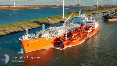
ARCTIC GAS
Not available
Current Trip
| Time Travelled | 12 days |
|---|---|
| Remaining Time | --- |
| Distance Travelled | 3380.99 nm |
| Remaining Distance | --- |
| AVG Speed | 13.2 Knots |
| MAX Speed | 17.6 Knots |
| AVG Wind | 9.6 knots |
| MAX Wind | 22.9 knots |
| MIN Temp | 5.1°C / 41.18°F |
| MAX Temp | 29°C / 84.2°F |
| Draught | 9 m |
| Position Received | 50 m ago |
Current Position
| Longitude | --- |
|---|---|
| Latitude | --- |
| Status | Under way using engine |
| Speed | 14 Knots |
| Course | 298° |
| Area | North Pacific Ocean |
| Station | T-AIS |
| Position Received | 50 m ago |
Info
Information
The current position of ARCTIC GAS is in North Pacific Ocean with coordinates 17.30453° / -104.92394° as reported on 2025-03-05 04:45 by AIS to our vessel tracker app. The vessel's current speed is 14 Knots and is heading at the port of ULSAN.
The vessel ARCTIC GAS (MMSI: 219025000) is a Not available It's sailing under the flag of [DK] Denmark.
In this page you can find informations about the vessels current position, last detected port calls, and current voyage information. If the vessels is not in coverage by AIS you will find the latest position.
The current position of ARCTIC GAS is detected by our AIS receivers and we are not responsible for the reliability of the data. The last position was recorded while the vessel was in Coverage by the Ais receivers of our vessel tracking app.
The current draught of ARCTIC GAS as reported by AIS is 9 meters
Weather
| Temperature | 24.5°C / 76.1°F |
|---|---|
| Wind Speed | 13 knots |
| Direction | 314° NW |
| Pressure | 1011.8 hPa |
| Humidity | 68.6 % |
| Cloud Coverage | 3 % |
Featured Company
Most Visited Ports (Last year)
| Port | Arrivals | |
|---|---|---|
| 4 | ||
| 2 | ||
| 2 | ||
| 1 |
Events
| Time | Event | Details | Position / Dest | Info |
|---|---|---|---|---|
| 2025-03-05 04:50 | Status Changed | Default Under way using engine |
17.31255 / -104.94071
PA CTB > KR USN
|
Speed: 14 kn Course: 298° |
| 2025-03-05 04:44 | Status Changed | Under way using engine Default |
17.30189 / -104.91879
PA CTB > KR USN
|
Speed: 14.1 kn Course: 296° |
| 2025-03-05 04:39 | Status Changed | Default Under way using engine |
17.29307 / -104.90095
PA CTB > KR USN
|
Speed: 14.1 kn Course: 299° |
| 2025-03-05 04:01 | Status Changed | Under way using engine Default |
17.21964 / -104.76383
PA CTB > KR USN
|
Speed: 14.5 kn Course: 300° |
| 2025-03-05 03:55 | Status Changed | Default Under way using engine |
17.20653 / -104.74010
PA CTB > KR USN
|
Speed: 14.1 kn Course: 300° |
| 2025-03-05 03:45 | Status Changed | Under way using engine Default |
17.18705 / -104.70441
PA CTB > KR USN
|
Speed: 14.3 kn Course: 300° |
| 2025-03-05 03:38 | Status Changed | Default Under way using engine |
17.17313 / -104.67911
PA CTB > KR USN
|
Speed: 14.1 kn Course: 300° |
| 2025-03-05 00:57 | Status Changed | Under way using engine Default |
16.87669 / -104.08513
PA CTB > KR USN
|
Speed: 13.9 kn Course: 298° |
| 2025-03-05 00:53 | Status Changed | Default Under way using engine |
16.87003 / -104.07191
PA CTB > KR USN
|
Speed: 13.9 kn Course: 297° |
| 2025-03-05 00:38 | Status Changed | Under way using engine Default |
16.84489 / -104.01789
PA CTB > KR USN
|
Speed: 14.3 kn Course: 295° |