
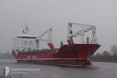
ALANIS
General Cargo
Current Trip
| Time Travelled | 14 days |
|---|---|
| Remaining Time | 4 days |
| Distance Travelled | 310.95 nm |
| Remaining Distance | 1383.54 nm |
| AVG Speed | 8.8 Knots |
| MAX Speed | 13.3 Knots |
| AVG Wind | 10.9 knots |
| MAX Wind | 18 knots |
| MIN Temp | 13.2°C / 55.76°F |
| MAX Temp | 21°C / 69.8°F |
| Draught | 7.1 m |
| Position Received | 13 h, 55 m ago |
Current Position
| Longitude | 23.20699° |
|---|---|
| Latitude | 36.41674° |
| Status | Under way using engine |
| Speed | 10.4 Knots |
| Course | 255.5° |
| Area | Aegean Sea |
| Station | T-AIS |
| Position Received | 13 h, 55 m ago |
Info
Information
The current position of ALANIS is in Aegean Sea with coordinates 36.41674° / 23.20699° as reported on 2024-05-12 18:16 by AIS to our vessel tracker app. The vessel's current speed is 10.4 Knots and is heading at the port of ALGECIRAS. The estimated time of arrival as calculated by MyShipTracking vessel tracking app is 2024-05-18 04:41 LT
The vessel ALANIS (IMO: 9468085, MMSI: 305469000) is a General Cargo that was built in 2010 ( 14 years old ). It's sailing under the flag of [AG] Antigua Barbuda.
In this page you can find informations about the vessels current position, last detected port calls, and current voyage information. If the vessels is not in coverage by AIS you will find the latest position.
The current position of ALANIS is detected by our AIS receivers and we are not responsible for the reliability of the data. The last position was recorded while the vessel was in Coverage by the Ais receivers of our vessel tracking app.
The current draught of ALANIS as reported by AIS is 7.1 meters
Weather
| Temperature | 19°C / 66.2°F |
|---|---|
| Wind Speed | 7 knots |
| Direction | 310° NW |
| Pressure | 1017.9 hPa |
| Humidity | 72.3 % |
| Cloud Coverage | --- |
Featured Company
Most Visited Ports (Last year)
| Port | Arrivals | |
|---|---|---|
| 2 | ||
| 1 | ||
| 1 | ||
| 1 | ||
| 1 | ||
| 1 |
Last Trips
Events
| Time | Event | Details | Position / Dest | Info |
|---|---|---|---|---|
| 2024-05-12 18:36 | Status Changed | Default Under way using engine |
36.41291 / 23.13230
ESALG
|
Speed: 10.4 kn Course: 255.5° |
| 2024-05-12 18:16 | OUT of Coverage |
36.41674 / 23.20699
Aegean Sea
ESALG
|
Speed: 10.4 kn Course: 255.5° |
|
| 2024-05-12 18:12 | Status Changed | Under way using engine Default |
36.42292 / 23.22084
ESALG
|
Speed: 11.2 kn Course: 214° |
| 2024-05-12 18:12 | IN Coverage |
36.41927 / 23.21583
Aegean Sea
ESALG
|
Speed: 10.1 kn Course: 241.1° |
|
| 2024-05-12 13:14 | Status Changed | Default Under way using engine |
37.33722 / 23.63722
ESALG
|
Speed: 12.4 kn Course: 190.4° |
| 2024-05-12 13:05 | OUT of Coverage |
37.36498 / 23.64371
Aegean Sea
ESALG
|
Speed: 12.4 kn Course: 190.4° |
|
| 2024-05-12 08:41 | Draught Changed | 7.1 5.9 |
37.90241 / 23.06758
ESALG
|
Speed: 7.1 kn Course: 114.8° |
| 2024-05-12 08:36 | Destination Changed | ESALG GRSOU |
37.90611 / 23.05936
ESALG
|
Speed: 5.3 kn Course: 126.8° |
| 2024-05-12 08:36 | ETA Changed | 2024/05/18 04:00 2025/04/29 04:00 |
37.90611 / 23.05936
ESALG
|
Speed: 5.3 kn Course: 126.8° |
| 2024-05-12 08:33 | START Moving | 0.52 nm, South of SOUSAKI |
37.90869 / 23.05462
GRSOU
|
Speed: 3.1 kn Course: 124° |